Search Results

Map of California, territories of New Mexico, Arizona, Colorado, Nevada and Utah, circa 1863
Date
1861 to 1865
Description
40 x 62 cm. Relief shown by hachures and spot heights. Prime meridians: Greenwich and Washington. "Historical and statistical view of the United States, 1860"--Verso. Atlas page numbers at top: 58-59. Arizona became a territory in 1863, and Nevada became a state on October 31, 1864, so this map was either published in 1863 or in 1864 before the end of October. Original publisher: Johnson and Ward.
Image
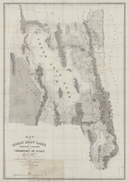
Map of the Great Salt Lake and adjacent country in the territory of Utah, 1850
Date
1849 to 1850
Description
108 x 75 cm. Map part hand colored. Relief shown by hachures and depths shown by soundings. Accompanies U.S. Army. Corps of Topographical Engineers. Exploration and survey of the valley of the Great Salt Lake of Utah. "Map of the Great Salt Lake and adjacent country in the Territory of Utah. Surveyed in 1849 and 1850, under the orders of Col. J. J. Abert, Chief of the Topographical Bureau, by Capt. Howard Stansbury of the Corps of Topographical Engineers, aided by Lieut. J. W. Gunnison Corps Topographical Engineers and Albet Carrington. Drawn by Lieut. Gunnison and Charles Preuss. Ackerman lith 379 Broadway N. Y." Original publisher: Ackerman Lith. Scale: 1:240,000.
Image
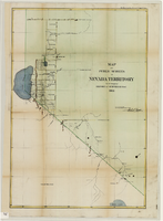
Map of public surveys in Nevada Territory to accompany report of Surveyor General, October 1, 1862
Date
1862-10-01
Description
'Surveyor Generals Office. San Francisco California October 1st 1862. [signed] E.F. Beale, U.S. Surv. Genl. Nevada Terry.' In upper right corner: 'Ho. Reps. Ex. Doc. No. 1. 37th Cong. 3d. Sess.' Relief shown by hachures. Scale [1:253,440] 1 in. to 4 miles (W 120°08--W 118°40/N 39°45--N 38°00)
Image
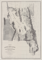
Map of the Great Salt Lake and adjacent country in the territory of Utah, 1852
Date
1852
Description
85 x 58 cm. "Available from the University of Utah Press, Salt Lake City, Utah 84112." Relief shown by hachures and spot heights; depths shown by soundings. "Scale 1:240,000"--inapplicable due to reproduction. Originally published to accompany Stansbury's report, Exploration and survey of the valley of the Great Salt Lake of Utah published in 1852 for the United States Army's Corps of Topographical Engineers. Includes text. Original publisher: University of Utah Press, Scale 1:240,000.
Image
Territorial Government, undated
Level of Description
File
Archival Collection
Las Vegas Library Regional History Files Collection
To request this item in person:
Collection Number: MS-00809
Collection Name: Las Vegas Library Regional History Files Collection
Box/Folder: Box 20
Collection Name: Las Vegas Library Regional History Files Collection
Box/Folder: Box 20
Archival Component
Red Territory, 2005
Level of Description
File
Archival Collection
Guide to the Canadian Film Centre Worldwide Short Film Festival Submissions
To request this item in person:
Collection Number: MS-00615
Collection Name: Guide to the Canadian Film Centre Worldwide Short Film Festival Submissions
Box/Folder: Box 2005-027
Collection Name: Guide to the Canadian Film Centre Worldwide Short Film Festival Submissions
Box/Folder: Box 2005-027
Archival Component
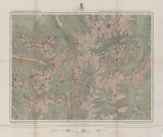
Map of economical features of Southwest Colorado, San Juan mining region, circa 1877
Date
1872 to 1880
Description
37 x 49 cm. Relief shown by hachures and spot heights. "Atlas sheet no. 61(C)." "Expeditions of 1874 & 1875 under the command of 1st. Lieut. Geo. M. Wheeler, Corps of Engineers, U.S. Army." "Louis Nell, del." "By order of the honorable the Secretary of War." "Under the direction of Brig. General A. A. Hunphreys, Chief of Engineers, U. S. Army." Original publisher: U.S. Geographical Surveys West of the 100th Meridian, Scale: 1 inch to 2 miles or 1: 126720.
Image
Henderson: Montana Territory, 1991
Level of Description
File
Archival Collection
UNLV Libraries Collection of Regional History Files
To request this item in person:
Collection Number: MS-00547
Collection Name: UNLV Libraries Collection of Regional History Files
Box/Folder: Box 23
Collection Name: UNLV Libraries Collection of Regional History Files
Box/Folder: Box 23
Archival Component
Western Territorial Conference, 1966
Level of Description
File
Archival Collection
International Food Service Executives Association Records
To request this item in person:
Collection Number: MS-00305
Collection Name: International Food Service Executives Association Records
Box/Folder: Box 033 (Restrictions apply)
Collection Name: International Food Service Executives Association Records
Box/Folder: Box 033 (Restrictions apply)
Archival Component
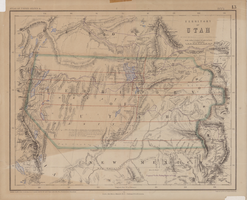
Map of territory of Utah, 1857
Date
1857
Description
31 x 39 cm. Relief shown by hachures and spot heights. "Entered in Sta. Hall London & according to act of Congress in the year 1857 by H.D. Rogers in the Clerks Office of the District Court of Massachusetts." Includes proposed Pacific railway routes. In upper margin: Atlas of United States &c., 13. Original publisher: John Murray, Scale: 3,450,000 of nature, 54 1.
Image