
Search the Special Collections and Archives Portal

Search Results

Display    Results Per Page
Displaying results 13321 - 13330 of 19632

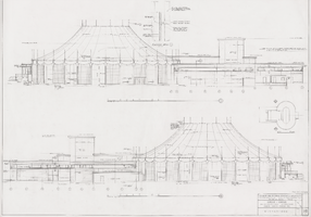
Architectural drawing of Circus Circus (Las Vegas), exterior elevations, April 5, 1968

Date

1968-04-05

Description

External elevations for the construction of the Circus Circus casino from 1968. Printed on parchment.
Site Name: Circus Circus Las Vegas
Address: 2880 Las Vegas Boulevard South

Image

Helen J. Stewart Photographs

Identifier

PH-00104

Abstract

The Helen J. Stewart Photographs depict the Stewart Family from approximately 1860 to 1950. The photographs primarily depict Helen J. Stewart and her children as well as the Stewart Ranch (also know as the Las Vegas Ranch) in Southern Nevada. The photographs include the early Las Vegas, Nevada town site, landscapes of Southern Nevada and the American Southwest, mines and mining camps, railroads and railroad workers, the Las Vegas Fort (also known as the Old Mormon Fort), hotels and early businesses in Las Vegas, Native Americans and Native American artifacts, and postcards.

Archival Collection

Environmental Radiation Protection Standards for Yucca Mountain, Nevada

Identifier

MS-00603

Abstract

The Environmental Radiation Protection Standards for Yucca Mountain, Nevada collection (1957-2010) is an information docket established by the U. S. Environmental Protection Agency (EPA). The collection contains documents supporting the development of regulatory decisions by the EPA on radiation protection standards for Yucca Mountain, Nevada, evaluating it as a potential site for a radioactive waste storage repository. The collection includes regulatory notices, technical documents, environmental reports, letters, minutes of meetings, public comments, and other materials.

Archival Collection

Dr. Lonnie D. Spight oral history interview

Identifier

OH-01747

Abstract

Oral history interview with Lonnie D. Spight conducted by David Emerson on May 08, 2007 for the UNLV @ 50 Oral History Project. In this interview, Lonnie D. Spight discusses being hired to teach physics at the University of Nevada, Las Vegas Physics Department in 1970. He also discusses serving as chair of the department several times, working on solar energy and far- field microwave analysis, and helping set up safety standards for laser technology.

Archival Collection

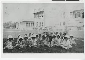
Photograph of a class from the Las Vegas Grammar School, Las Vegas (Nev.), 1935-1945

Date

1935 to 1945

Description

A class of children sitting on the lawn at the Las Vegas Grammar School. The girls are wearing ruffled sun bonnets. Officially called the Las Vegas Grammar School, the complex has informally been referred to as the Fifth Street School almost since its inception, due to its location on Fifth Street (renamed Las Vegas Boulevard in 1959) in downtown Las Vegas. The complex functioned as a school, each year serving between 150 to 200 students in grades first through eighth, until 1966. It sat empty until 1970, when it was converted into Clark County offices. It was acquired by the city of Las Vegas from the county in 1996. Now officially called the Historic Fifth Street School, the building and its site are listed in the National Register of Historic Places and the city of Las Vegas Historic Property Register. Site Name: Las Vegas Grammar School (Las Vegas, Nev.) Street Address: 401 South Las Vegas Boulevard

Image

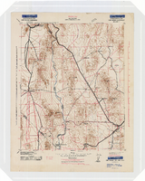
Topographic map of the Camp Mohave quadrangle in California, Nevada and Arizona, 1942

Date

1942

Description

Scale 1;250,000 ; polyconic projection (W 115°--W 114V/N 36V--N 35V) ; 1 map : col. ; 52 x 37 cm ; Relief shown by contours and spot heights. Contour interval 250 feet ; "Training map"--Center of upper margin of map ; "Base compiled from U.S. Geological Survey quadrangles. Control from U.S. Geological Survey. Revised from state highway maps for Arizona, Nevada and California" ; "Culture revisions shown in red based on reconnaissance by 67th Engr. Co. (Top.). May not be of same accuracy as base map." ; Map shows roads, trails, ponton sites, dam sites, possible air fields, possible landing fields, airports, water points, and impassable areas ; Map was originally restricted. "Classification cancelled by authority of Chief of Engineers letter of Jan. 22, 1946." ; Title at top of map: Nevada-Arizona-California : Camp Mohave quadrangle : grid zone F ; Army Map Service, U.S. Army.

Image

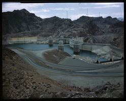
Film transparency of Hoover (Boulder) Dam, taken from the upstream side of the dam on the Arizona side, May, 1947

Date

1947-05

Description

Hoover (Boulder) Dam, taken from the upstream side of the dam on the Arizona side, May, 1947. The intake towers, Nevada spillway house (in the background, behind the intake towers), and the Nevada spillway are visible. During the years of lobbying leading up to the passage of legislation authorizing the dam in 1928, Hoover Dam was originally referred to "Boulder Dam" or as "Boulder Canyon Dam", even though the proposed site had shifted to Black Canyon. The Boulder Canyon Project Act of 1928 (BCPA) never mentions a proposed name or title for the dam. When Secretary Wilbur spoke at the ceremony starting the building of the railway between Las Vegas and the dam site on September 17, 1930, he named the dam "Hoover Dam", citing a tradition of naming dams after Presidents, though none had been so honored during their terms of office. After Hoover's election defeat in 1932 and the accession of the Roosevelt administration, Secretary Ickes ordered on May 13, 1933 that the dam be referred to as "Boulder Dam". In the following years, the

Image

Film transparency of Hoover (Boulder) Dam, taken from the upstream side of the dam on the Nevada side, May, 1947

Date

1947-05

Description

Hoover (Boulder) Dam, taken from the upstream side of the dam on the Nevada side. May, 1947. The intake towers, Nevada spillway house (in the background, behind the intake towers), and the Nevada spillway are visible. During the years of lobbying leading up to the passage of legislation authorizing the dam in 1928, Hoover Dam was originally referred to "Boulder Dam" or as "Boulder Canyon Dam", even though the proposed site had shifted to Black Canyon. The Boulder Canyon Project Act of 1928 (BCPA) never mentions a proposed name or title for the dam. When Secretary Wilbur spoke at the ceremony starting the building of the railway between Las Vegas and the dam site on September 17, 1930, he named the dam "Hoover Dam", citing a tradition of naming dams after Presidents, though none had been so honored during their terms of office. After Hoover's election defeat in 1932 and the accession of the Roosevelt administration, Secretary Ickes ordered on May 13, 1933 that the dam be referred to as "Boulder Dam". In the following years, the n

Image

Fremont Hotel and Casino additions and alterations: architectural drawings, image 015

Date

1967-12-01

Description

Architectural sheet for the Fremont Hotel and Casino from flat file 001a of the Martin Stern Architectural Records. This sheet contains a drawing sheet index, a site location plan for existing conditions, excavation notes, an excavation and demolition plan, and sections of the excavation and demolition area.