Search Results
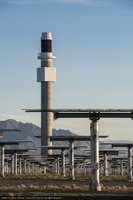
Heliostats (mirrors) at Crescent Dunes Solar, near Tonopah, Nevada: digital photograph
Date
2014-06-24
Archival Collection
Description
Photographer's note: "10,347 heliostats (mirrors) are part of the Crescent Dunes Solar project. Each heliostat is 34 feet tall, uses 35 mirrors, and has a surface area of 1258 square feet, or 115.7 square meters. The tower with its black receiver is in the background. On site photo, Crescent Dunes Solar, near Tonopah, Nevada, USA."
Photographer's assigned keywords: "110 megawatts; CSP; Concentrated Solar Energy; Concentrated Solar Power; Crescent Dunes; NV; Nevada; Solar Reserve; SolarReserve; Tonopah; concentrated solar thermal; green energy; ground-based photo; molten salt; on-site; renewable energy; storage; tower."
Photographer's assigned keywords: "110 megawatts; CSP; Concentrated Solar Energy; Concentrated Solar Power; Crescent Dunes; NV; Nevada; Solar Reserve; SolarReserve; Tonopah; concentrated solar thermal; green energy; ground-based photo; molten salt; on-site; renewable energy; storage; tower."
Image
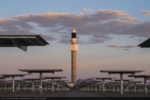
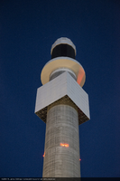
The 540 foot (165 meter) high tower, Crescent Dunes Solar, near Tonopah, Nevada: digital photograph
Date
2014-06-24
Archival Collection
Description
Photographer's note: "The 540 foot (165 meter) high tower at the center of Crescent Dunes Solar's plant is where the sun's thermal energy is directed to a black target area atop the tower. This is where molten salt pumped up from below is heated to 1050°F (566°C). On site photo, Crescent Dunes Solar, near Tonopah, Nevada, USA."
Photographer's assigned keywords: "110 megawatts; CSP; Concentrated Solar Energy; Concentrated Solar Power; Crescent Dunes; NV; Nevada; Solar Reserve; SolarReserve; Tonopah; concentrated solar thermal; green energy; ground-based photo; molten salt; on-site; renewable energy; storage; tower."
Photographer's assigned keywords: "110 megawatts; CSP; Concentrated Solar Energy; Concentrated Solar Power; Crescent Dunes; NV; Nevada; Solar Reserve; SolarReserve; Tonopah; concentrated solar thermal; green energy; ground-based photo; molten salt; on-site; renewable energy; storage; tower."
Image
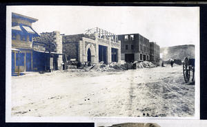
Photograph of a construction of Goldfield News building and Goldfield Hotel, Goldfield (Nev.), 1900-1920
Date
1900 to 1920
Archival Collection
Description
Site Name: Goldfield Hotel (Goldfield, Nev.)
The News Building (Goldfield, Nev.)
The News Building (Goldfield, Nev.)
Image
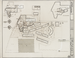
Architectural drawing of Sands Hotel (Las Vegas) additions and alterations, ultimate development plan, phase IV construction, February 5, 1964
Date
1964-02-05
Archival Collection
Description
Architectural plans for proposed additions and alterations to The Sands. Printed on mylar. Berton Charles Severson, architect; Brian Walter Webb, architect; Frank R. Bernard, delineator.
Site Name: Sands Hotel
Address: 3355 Las Vegas Boulevard South
Image
Kauffman, Gay, 1914-2009
Kauffman was born in Denver, Colorado in 1914.
He was employed at the Reynolds Electrical and Engineering Co.
Person
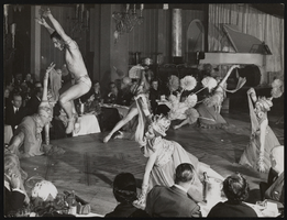
Photographs of performers in the Lido production "Rendez-Vous," Paris (FRA), 1951
Date
1951
Archival Collection
Description
Six photographs of the production "Rendez-Vous" performed at the Lido in Paris, France. The show was staged by Donn Arden. Images were created by Studio Renoux. Site Name: Lido (Cabaret: Paris, France)
Image
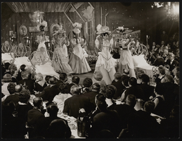
Photographs of Lido production "Suivez-Moi!", Paris (FRA), 1962
Date
1962
Archival Collection
Description
Two photos from the production "Suivez-Moi!", a show staged by Donn Arden at the Lido in Paris, France. Depicted is the scene "Last Frontier Hotel." Site Name: Lido (Cabaret: Paris, France)
Image
Photographs of Lido production "Suivez-Moi!", Paris (FRA), 1962
Date
1962
Archival Collection
Description
Four photographs of the production "Suivez-Moi!", a show staged by Donn Arden at the Lido in Paris, France. The scene depicted is "La Fontaine de Trevi." Site Name: Lido (Cabaret: Paris, France)
Image
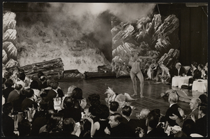
Photographs of Donn Arden's "Hello America," Las Vegas (Nev.), 1964
Date
1964
Archival Collection
Description
Six photos of miscellaneous scenes and dancers in Donn Arden's production "Hello America," a tribute to America's past, held at the Stardust Hotel in Las Vegas, Nevada. Site Name: Stardust Resort and Casino
Image