Search Results
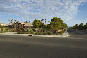
Luxury home in a neighborhood east of Buffalo Drive and north of West Sahara Avenue, looking north, Las Vegas, Nevada: digital photograph
Date
2017-10-11
Archival Collection
Description
A custom home occupies the northwest corner of Via Olivero Avenue and Tioga Way near Buffalo Drive and West Sahara Avenue.
Image
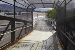
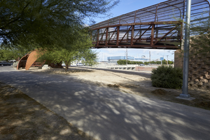
Bridge connecting to a path east of Lamb Boulevard south of East Sahara Avenue, looking east, Las Vegas, Nevada: digital photograph
Date
2017-09-26
Archival Collection
Description
A bridge that is part of the Flamingo Arroyo Trail system leads to a path on the east side of Lamb Boulevard south of East Sahara Avenue.
Image
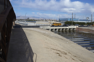
Bridge and Flamingo Wash cross Lamb Boulevard south of East Sahara Avenue, looking west, Las Vegas, Nevada: digital photograph
Date
2017-09-26
Archival Collection
Description
A bridge that is part of the Flamingo Arroyo Trail system parallels the Flamingo Wash as they cross Lamb Boulevard south of East Sahara Avenue.
Image
Bridge and Flamingo Wash cross Lamb Boulevard south of East Sahara Avenue, looking west, Las Vegas, Nevada: digital photograph
Date
2017-09-26
Archival Collection
Description
A bridge that is part of the Flamingo Arroyo Trail system parallels the Flamingo Wash crosses Lamb Boulevard south of East Sahara Avenue.
Image
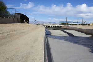
Flamingo Arroyo Trail system at Lamb Boulevard south of East Sahara Avenue, looking northwest, Las Vegas, Nevada: digital photograph
Date
2017-09-26
Archival Collection
Description
A bridge that is part of the Flamingo Arroyo Trail system parallels the Flamingo Wash near Lamb Boulevard south of East Sahara Avenue.
Image
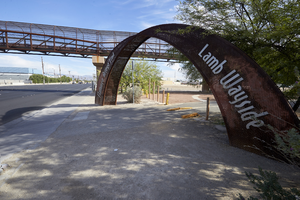
Flamingo Arroyo Trail system at Lamb Boulevard south of East Sahara Avenue, looking north, Las Vegas, Nevada: digital photograph
Date
2017-09-26
Archival Collection
Description
A bridge that is part of the Flamingo Arroyo Trail system and parallels the Flamingo Wash is seen at Lamb Boulevard south of East Sahara Avenue.
Image
Sahara Hotel's music-themed float in the Helldorado Days Parade, Las Vegas, approximately 1950-1959
Level of Description
File
Archival Collection
Union Pacific Railroad Photographs
To request this item in person:
Collection Number: PH-00043
Collection Name: Union Pacific Railroad Photographs
Box/Folder: Folder 08
Collection Name: Union Pacific Railroad Photographs
Box/Folder: Folder 08
Archival Component
Color plate "The Fabulous Strip". Logos for the Sands, Sahara, Riviera, Tropicana, Flamingo, and Dunes are featured, undated
Level of Description
File
Archival Collection
Culinary Workers Union Local 226 Las Vegas, Nevada Photographs
To request this item in person:
Collection Number: PH-00382
Collection Name: Culinary Workers Union Local 226 Las Vegas, Nevada Photographs
Box/Folder: Box 38
Collection Name: Culinary Workers Union Local 226 Las Vegas, Nevada Photographs
Box/Folder: Box 38
Archival Component
Color view of the Thunderbird Hotel. The El Rancho Vegas Hotel and the Sahara Hotel are visible in the background, undated
Level of Description
File
Archival Collection
Culinary Workers Union Local 226 Las Vegas, Nevada Photographs
To request this item in person:
Collection Number: PH-00382
Collection Name: Culinary Workers Union Local 226 Las Vegas, Nevada Photographs
Box/Folder: Box 38
Collection Name: Culinary Workers Union Local 226 Las Vegas, Nevada Photographs
Box/Folder: Box 38
Archival Component
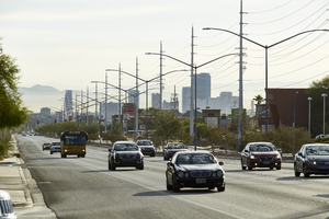
Cars on West Sahara Avenue east of Buffalo Drive with power lines and part of the Strip, looking east, Las Vegas, Nevada: digital photograph
Date
2017-10-11
Archival Collection
Description
Traffic flows along West Sahara Avenue east of Buffalo Drive. Sahara is a major power transmission corridor for much of its 18 mile length. Part of the Las Vegas strip can be seen in the background.
Image