Search Results

A railroad crossing Eastern Avenue north of Warm Springs Road, looking west-northwest in Las Vegas, Nevada: digital photograph
Date
Archival Collection
Description
From the UNLV University Libraries Photographs of the Development of the Las Vegas Valley, Nevada (PH-00394). Part of the collection documents the entire 19 mile length of the north/south Eastern Avenue / Civic Center Drive alignment. This photograph was captured in the section of Eastern Avenue between Sunset and Warm Springs Roads.
Image

Railroad crossing Eastern Avenue north of Warm Springs Road, looking south-southeast in Las Vegas, Nevada: digital photograph
Date
Archival Collection
Description
From the UNLV University Libraries Photographs of the Development of the Las Vegas Valley, Nevada (PH-00394). Part of the collection documents the entire 19 mile length of the north/south Eastern Avenue / Civic Center Drive alignment. This photograph was captured in the section of Eastern Avenue between Sunset and Warm Springs Roads.
Image
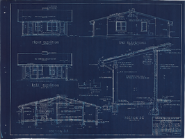
Elevation and sections plans for Los Angeles & Salt Lake Railroad Company four room bunkhouse near Caliente, Nevada: architectural drawing
Date
Archival Collection
Description
From Union Pacific Railroad Collection (MS-00397). The scales are noted in the drawing. The bottom corner of the drawing says, "Union Pacific System L.A. & S.L.R.R. Standard 4 Room Bunk House Located West Of Caliente. Elevations, Sections. Asst. Chief Engineer's Office Los Angeles Calif. Drawn By A.J.R. Traced By A.J.R. Checked By F.W.G. Date Dec. 22-26. Scales As Shown. Revised. Drawing No 15659-B".
Image
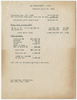
Breakdown of costs of water for the Union Pacific Railroad and the Las Vegas Land and Water Co. in 1934, February 15, 1935
Date
Archival Collection
Description
Breakdown of costs of water for the Union Pacific Railroad and the Las Vegas Land and Water Co. in 1934.
Text

A railroad crossing Eastern Avenue north of Warm Springs Road, looking south in Las Vegas, Nevada: digital photograph
Date
Archival Collection
Description
From the UNLV University Libraries Photographs of the Development of the Las Vegas Valley, Nevada (PH-00394). Part of the collection documents the entire 19 mile length of the north/south Eastern Avenue / Civic Center Drive alignment. This photograph was captured in the section of Eastern Avenue between Sunset and Warm Springs Roads.
Image
Union Pacific Railroad: contains railroad track maps in California including Los Angeles and Ontario. Also includes state maps of Montana, Nevada, New Mexico, Oregon, Washington, Wyoming, Arizona, and California, 1946 June 18
Level of Description
Archival Collection
Collection Name: Union Pacific Railroad Collection
Box/Folder: Flat File 190
Archival Component
Union Pacific Railroad supporting infrastructure and facilities: contains architectural drawings of mechanical and supporting buildings in Las Vegas, Nevada and maps of the Las Vegas Union Pacific Railroad System, 1905 January 12-1928 May 05
Level of Description
Archival Collection
Collection Name: Union Pacific Railroad Collection
Box/Folder: Flat File 165
Archival Component
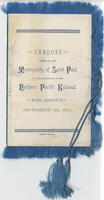
Banquet given by the Municipality of Saint Paul on the completion of the Northern Pacific Railroad, menu, September 3, 1883 at Hotel Lafayette
Date
Archival Collection
Description
Text
Rex Bell on horseback in a parade: Stamped on back "Union Pacific Railroad Photo", 1930 to 1970
Level of Description
Archival Collection
Collection Name: Walking Box Ranch Photograph Collection
Box/Folder: N/A
Archival Component
The Cripple of the Railroad, no. 250. London: printed for the Society for Promoting Christian Knowledge, 1841
Level of Description
Archival Collection
Collection Name: Mavis Eggle "Books as They Were Bought" Collection
Box/Folder: Box 27
Archival Component