Search the Special Collections and Archives Portal
Search Results
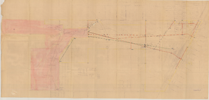
Map of Las Vegas Valley Water District, December 29, 1952
Date
1952-12-29
Archival Collection
Description
'Exhibit A.' 'Dec. 29, 1952.' 'I-128.' Scale [ca. 1:3,600]. 1 in.=300 feet. Shows water pipelines, other parts of the water system, and power lines to be removed or relocated when land is sold to the Las Vegas Valley Water District. Shows land to be sold and lists power requirements for water system. Includes township and range lines. Library's copy includes hand-written notations and calculations. Los Angeles & Salt Lake Railroad Company, Office of Vice President?
Image
Maps, Drawings, and Plans, 1903-1969
Level of Description
Sub-Series
Scope and Contents
The Maps, Drawings, and Plans sub-series (1903-1969) contains schematic drawings of railroad sections and crossings, and wells. It also contains annual reports and records books.
Archival Collection
Union Pacific Railroad Collection
To request this item in person:
Collection Number: MS-00397
Collection Name: Union Pacific Railroad Collection
Box/Folder: N/A
Collection Name: Union Pacific Railroad Collection
Box/Folder: N/A
Archival Component
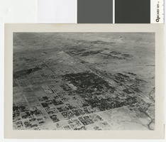
Aerial photograph of Las Vegas, full view of high school, southwest direction, 1930
Date
1930
Archival Collection
Description
Aerial view of Las Vegas in 1930
Transcribed Notes: Notes on back of duplicate photo: Aerial view of Las Vegas w/ new high school on bottom left, c. 1933; Notes on photo sleeve: Aerial view of Las Vegas taken in the winter of 1930 (same day as #0123 002) in clip wing Jenny. Shows railroad and main street - essentially shows the whole city. (Credit: W.A. Davis)
Image
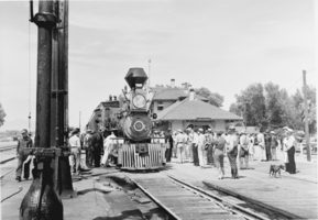
Film transparency of a locomotive train in Las Vegas, circa 1938
Date
1938
Archival Collection
Description
Black and white image of a Virginia & Truckee locomotive promoting C.B. DeMille's motion picture, "Union Pacific."
Image
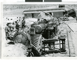
Photograph of a passenger train collision, Nevada, 1907-1930
Date
1907 to 1930
Archival Collection
Description
A picture of Bullfrog-Goldfield after collision with southbound Tonopah & Tidewater passenger train.
Image
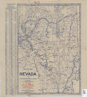
Sketch map of Nevada and the southeastern portion of California, 1906
Date
1906
Description
1907 written in red pencil at top of map. 41 x 29 cm. Relief shown by hachures. Copyright held by George S. Clason. Includes index. "Compliments of A.E. Holt, real estate and mines, Bullfrog Mining Dist., Rhyolite, Nevada." Red star indicates location of A.E. Holt company. Shows railroad routes. Library's copy has "1907" printed with brown crayon in upper margin and has four sets of two holes punched in a vertical line along the right third of the map. Original publisher: Clason Map Co..
Image
Pagination
Refine my results
Content Type
Creator or Contributor
Subject
Archival Collection
Digital Project
Resource Type
Year
Material Type
Place
Language
Records Classification

