Search Results

Photograph of a parade on Fremont Street (Las Vegas), 1956
Date
Archival Collection
Description
Parade on Fremont Street showing views of the façades of the Pioneer Club, California Club and others. Stamped on original: "Please credit Union Pacific Railroad Photo, Public Relations Department, 422 West 6th St., Los Angeles 14, Calif, File Print Stock, Los Angeles Neg."
Site Name: Fremont Street
Address: Fremont street, Las Vegas, NV
Image
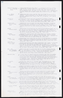
Photograph of a woman drawing in front of the Sands Hotel (Las Vegas), mid-1950s
Date
Archival Collection
Description
View of the front of the Sands, including its sign and front parking area, in the mid-1950s. Stamped on original: "Please credit Union Pacific Railroad Photo, Public Relations Department, 422 West 6th St., Los Angeles 14, Calif, File Print Stock, Los Angeles Neg."
Site Name: Sands Hotel
Address: 3355 Las Vegas Boulevard South
Image
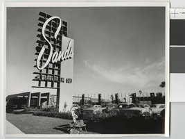
Photograph of entrance of the New Frontier (Las Vegas), after 1955
Date
Archival Collection
Description
View of the façade, entrance, and neon sign of the New Frontier from Las Vegas Boulevard. Stamp on back of photo: "Please credit Union Pacific Railroad Photo, Public Relations Department, 422 West 6th St., Los Angeles 14, Calif, File Print Stock, Los Angeles Neg."
Site Name: Frontier
Address: 3120 Las Vegas Boulevard South
Image
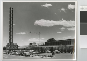
Architectural drawing of Riviera Hotel and Casino (Las Vegas), west elevation, July 28, 1954
Date
Archival Collection
Description
West elevation of the Riviera Hotel and Casino labeled as "A 313 room hotel to be erected at the corner of U.S. Highway 91 and Race Track Road, Las Vegas, Nevada." Drawn by H.G.H., F.M., and W.W. Includes revision dates. Original medium: pencil on paper.
Site Name: Riviera Hotel and Casino
Address: 2901 Las Vegas Boulevard South
Image
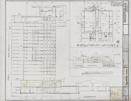
Architectural drawing of Harrah's Tahoe (Stateline, Nev.), tower cross section, December 1, 1971
Date
Archival Collection
Description
Tower cross section, partial third floor plan, and schematic section and elevation for the wall between the "existing and new" casino for the construction of Harrah's Lake Tahoe. Original material: mylar. Berton Charles Severson, architect; Brian Walter Webb, architect; Redmond, delineator.
Site Name: Harrah's Tahoe
Address: 15 Highway 50
Image
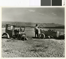
Photograph of two cars abandoned by their owners in St. Thomas, Nevada, April 11, 1948
Date
Archival Collection
Description
Remains of two cars, most likely near the remains of Hugh Lord's shop, in St Thomas, Nevada, when the town emerged from the waters of Lake Mead in 1945
Transcribed Notes: Bureau of Reclamation typed notes appended to back of photo: Boulder Canyon Project--Nevada--Region 3 St. Thomas, Nevada, was founded by the Mormons in 1855. In its heyday there were about 800 residents in the village. The "Main Street" was a part of the old Arrowhead Trail, which led from Salt Lake City, Utah to Los Angeles, California. In June 1938 the town was abandoned by its residents, which at that time were few in number because of the rising waters of Lake Mead that submerged the townsite. Photograph shows a closeup of two cars abandoned by their owners. Note the wide wooden wheel on the car to the right; also, the smaller wheel with wooden spokes. The wide wooden wheel was used as an "engine" to pump water, the belt being placed on this wooden wheel.
Image

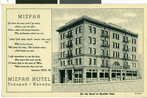
Postcard of Mizpah Hotel, Tonopah (Nev.), 1905
Date
Archival Collection
Description
Image