
Search the Special Collections and Archives Portal

Search Results

Display    Results Per Page
Displaying results 111 - 120 of 576760

Nevada Library Notes

Date

1968 to 1969

Description

Nevada Library Notes, Vol. 5-6 issued by the Nevada State Library. Materials about the news of library activities and articles for publication by Nevada librarians. It also contains the Nevada Library Association directory from 1967 to 1969. 

Text

Nevada Library Notes

Date

1972 to 1973

Description

Nevada Library Notes, Vol. 9-10 issued by the Nevada State Library. Materials about the news of library activities and articles for publication by Nevada librarians. It also contains the Nevada Library Association directory issue from 1971 to 1973.

Text

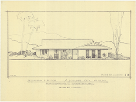
Architectural drawing of residential home in Boulder City, Nevada, preliminary elevation, September 19, 1962

Date

1962-09-19

Description

Preliminary drawing of front exterior elevation of a ranch-style residential home in Boulder City, Nevada.

Architecture Period: Mid-Century Modernist

Image

Topographic map of Nevada-California, Las Vegas quadrangle, 1951

Date

1951

Description

'Edition of Mar. 1908, reprinted 1951.' 'E.M. Douglas, geographer in charge; Topography and triangulation by R.H. Chapman, B.D. Stewart, J.E. Blackburn, and D.F.C. Moor. Surveyed in 1906-1907.' Scale 1:250,000 ; polyconic proj. (W 116°00--W 115°00/N 37°00--N 36°00). Relief shown by contours and spot heights. Title in lower-right corner: Nev.-Calif., Las Vegas. Contour interval 100 feet. Datum is mean sea level. U.S. Geological Survey

Image

Map showing location of the Las Vegas & Tonopah Railroad from Las Vegas to Bullfrog, Nevada, 1906

Date

1906

Description

'Office of Chief Engineer' printed on map above date.

Image

Map of the territories of New Mexico, Arizona, Colorado, Nevada, and Utah, 1855

Date

1855

Description

29 x 36 cm. Relief shown by hachures. Prime meridians: Greenwich and Washington. "Entered according to act of Congress in the year 1855 by J.H. Colton & Co. in the Clerk's Office of the Dist. Office of the U.S. for the Southern. Dist. of New York." Hand colored. Decorative border. Atlas p. number in lower-right margin: 67. Shows routes of explorers, proposed railroad routes, wagon route, mail route, Indian reserves and mines. On verso: History and statistical view of Mexico. Original publisher: J.H. Colton.

Image

Map of California, with territories of Utah, Nevada, Colorado, New Mexico, and Arizona, 1864

Date

1864

Description

40 x 62 cm. Relief shown by hachures. Prime meridians: Greenwich and Washington. Page numbers at top: 58-59. "Entered according to act of Congress in the year 1864 by A. J. Johnson in the Clerk's Office of the District Court of the United States for the Southern District of New York." Original publisher: Johnson and Ward.

Image

Topographic map of the northeast quadrangle of the metropolitan Las Vegas, Nevada area, 1967

Date

1967

Description

Scale 1:24,000 ; polyconic proj. (W 115°730--W 115°0000/N 36°1500--N 36°730) ; 1 map : col. ; 58 x 47 cm ; 7.5 minute series (topographic) ; Relief shown by contours and spot heights ; Filing title: Las Vegas NE, Nev ; "AMS 2956 II NE--Series V896." ; Contour interval 20 feet ; "Topography by photogrammetric methods from aerial photographs taken 1965. Field checked 1967." ;Includes quadrangle location map ; Interior--Geological Survey

Image

Topographic map of the northeast quadrangle of the metropolitan Las Vegas, Nevada area, 1973

Date

1973

Description

Scale 1:24,000 ; polyconic proj. (W 115°730--W 115°0000/N 36°1500--N 36°730) ; 1 map : col. ; 58 x 47 cm ; 7.5 minute series (topographic) ; Relief shown by contours and spot heights ; "AMS 2956 II NE--Series V896." ; Contour interval 20 feet ; "Topography by photogrammetric methods from aerial photographs taken 1965. Field checked 1967." ; "Revisions shown in purple compiled from aerial photographs taken 1973. This information not field checked." ; Includes quadrangle location map ; Filing title: Las Vegas, NE, Nev ; Interior--Geological Survey

Image

Topographic map of the northwest quadrangle of the metropolitan Las Vegas, Nevada area, 1967

Date

1967

Description

Scale 1:24,000 ; polyconic proj. (W 115°1500--W 115°730/N 36°1500--N 36°730) ; 1 map : col. ; 58 x 47 cm ; 7.5 minute series (topographic) ; Relief shown by contours and spot heights ; Filing title: Las Vegas NW, Nev ; "AMS 2956 II NW--Series V896." ; Contour interval 10 feet ; "Topography by photogrammetric methods from aerial photographs taken 1965. Field checked 1967." ; Includes quadrangle location map ; Interior--Geological Survey

Image