Search Results
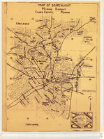
Map of Searchlight mining district, Clark County, Nevada, circa 1905
Date
Description
Image
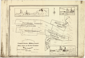
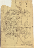
Map of properties in the Tonopah Mining District, Nye County, Nevada, circa 1901
Date
Description
Image
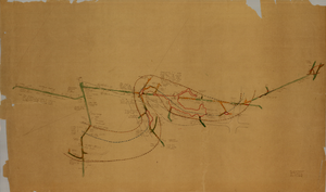
Map of the fourth level of the Clermont Mine, elevation 5228.8 feet, Goldfield, Nevada, circa 1902-1908
Date
Description
Image
Goldfield Consolidated Mines Company Records
Identifier
Abstract
The Goldfield Consolidated Mines Company Records (1904-1930) consist of correspondence, invoices, receipts with voucher checks, mining leases, insurance policies, payroll accounts, published notices and articles. Also included is a monthly Goldfield Consolidated Mines reports ledger from February 1914 to October 1916 for mines located in the south central Nevada area. The collection primarily dates from 1904, before the consolidation when the boom in Goldfield was beginning in earnest, until 1919, when the company ceased its operations in Goldfield, although there are a few records post-1919 as the company continued to exist after the mines and mill closed down.
Archival Collection
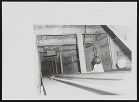
Photograph of mine shaft at Johnnie Mine, Pahrump (Nev.), 1940s
Date
Archival Collection
Description
Image
Map of approved mineral surveys in the Goldfield Mining District, Esmeralda and Nye Counties, Nevada, 1911
Date
Description
Image
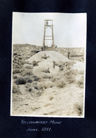
Photograph of a mining headframe at the Yellowjacket Mine, Pioneer (Nev.), 1911
Date
Archival Collection
Description
Image
Mines and Mining, 1966-1971
Level of Description
Archival Collection
Collection Name: Las Vegas Library Regional History Files Collection
Box/Folder: Box 15
Archival Component
Mines and Mining, 1906-1970
Level of Description
Archival Collection
Collection Name: Las Vegas Library Regional History Files Collection
Box/Folder: Box 15
Archival Component