
Search the Special Collections and Archives Portal

Search Results

Display    Results Per Page
Displaying results 21 - 30 of 16009

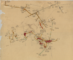
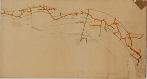
Map of the 600 foot, or third, level of the Clermont Mine, Goldfield, Nevada, circa 1902-1908

Date

1902 to 1908

Description

Hand-drawn, hand-colored and annotated map showing the 600 foot, or third, level of the Clermont Mine. Handwritten at top of map: 'Clermont, 3rd level.'

Image

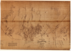
Map of the Bullfrog Mining District, Nye County, Nevada, circa 1905

Date

1901 to 1909

Description

'Compiled by Geo. E. Sherer and W.B. Milliken, miners and surveyors, Bull Frog, Nye Co., Nevada.' 'Photo. Lith. Britton & Rey, S.F.' Scale [ca. 1:16,800. 1 inch to approximately 1,400 feet]. Blueline print.

Image

Longitudinal section map, Montana Tonopah Mine, circa 1900s-1910s

Date

1900 to 1919

Description

'Longitudinal Section, Montana Tonopah Mine showing workings projected on east-west vertical plane.' In lower right corner: 'E.D. North E.M.' 'Photo-litho. Britton & Rey, S.F.'

Image

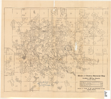
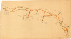
Map of the Goldfield Mining District, Goldfield, Nevada, 1907

Date

1907

Description

'Elmer J. Chute, E.M. and Olmstead and Rich, Goldfield, Nevada. Copyright 1907, by Elmer J. Chute, Goldfield, Nev.' Includes information on and prices for wall and pocket map with this title. Includes inset map. Includes township and range grid. Library's copy has Rochester GF. claim circled in blue ink , has a piece missing to the right of that claim, and has "Mohawk ledge, a lease by Davis & Shoemaker" written in blue ink at the center bottom of the map with a line in blue ink drawn to the Frances Mohawk claim.

Image

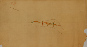
Map of the 280 foot level of the Combination Mine, Goldfield, Nevada, circa 1902-1908

Date

1902 to 1908

Description

Hand-drawn, hand-colored and annotated map showing the 280 foot level of the Combination Mine. Printed on map: 'Mohawk, col. el. 5958.48; Hayes & Monnette No. 2, col. el. 5935.7; Hayes & Monnette No. 1, col. el. 5925.8; Truett, col. el. 5938.8; Combination, col. el. 5986.31.'

Image

Tonopah Mining Company Records

Identifier

MS-00752

Abstract

The Tonopah Mining Company Records derive from the office of the company’s general manager in Tonopah, Nevada and consist of documents directly generated by its mining and milling operations from 1901 through 1941. The collection includes daily work reports, assay reports and certificates, employee time cards, invoices and receipts for mining equipment and supplies, monthly stores reports, and the company’s numerous insurance policies. Several of the company’s annual reports, including an original typescript copy of the 1907 annual report, are included in the collection. Additionally, select records from the company's subsidiary, Desert Power and Mill Company, as well as the Tonopah and Goldfield Railroad, which include overcharge claims, freight and repair bills, and delivery receipts are included in the collection.

Archival Collection

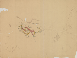
Map of the third level of the Red Top Mine, Goldfield, Nevada, circa 1902-1908

Date

1902 to 1908

Description

'Red Top 3rd level, 5659.90.' Hand-drawn, hand-colored and annotated map showing the third level of the Red Top Mine.

Image

Map of the fourth level of the Red Top Mine, Goldfield, Nevada, circa 1902-1908

Date

1902 to 1908

Description

'Red Top, 4th level. 5586.90.' Hand-drawn, hand-colored and annotated map showing the fourth level of the Rep Top Mine.

Image

Map of the first level of the Red Top Mine, Goldfield, Nevada, circa 1902-1908

Date

1902 to 1908

Description

'Red Top, 1st level. 5820.30.' Hand-drawn, hand-colored and annotated map showing the first level of the Red Top Mine.

Image

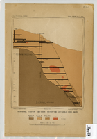
Vertical cross-section of Eureka Consolidated Mine, 1883

Date

1883

Description

'G. F. Becker, geologist-in-charge. Julius Bien & Co. lith. Mapping and geology by J. S. Curtis.' 'U.S. Geological Survey. Annual report 1883, pl. XXXIII.' Published by U.S. Geological Survey. Scale [ca. 1:2,400] 1 in.=200 feet. Library's copy has "Nev." printed in pencil in upper right corner.

Image