Search Results

Map of well locations, Las Vegas Valley, Nevada, 1975
Date
Description
Image

Plat showing original townsite and subdivisions, Las Vegas, Lincoln County, Nevada, May 1905
Date
Description
Land owned by the San Pedro, Los Angeles & Salt Lake Railroad is outlined. Scale: [ca. 1:12,000]. 1 inch = 1,000 feet. Cadastral map. Blueline print. Additional copy available in the J.T. McWilliams manuscript collection
Image

Map of the Las Vegas Strip, 1953
Date
Description
Image

Redevelopment plan map for downtown Las Vegas, Nevada, November 18, 1987
Date
Description
Image
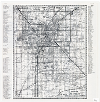
Map of greater Las Vegas area, 1964-1965
Date
Description
Text

Map of Las Vegas Valley showing artesian wells, circa 1920
Date
Description
Image

Map of the Las Vegas Strip, May 1950
Date
Description
Image
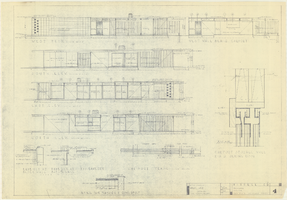
Architectural drawings of a residential home in Las Vegas, Nevada, November 2, 1962
Date
Description
Exterior elevations and details for a residential home on Fifth Place in Las Vegas, Nevada. Sheet no. 4. "Drw. D.H."
Architecture Period: Mid-Century ModernistImage
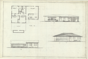
Architectural drawings of residential home in Las Vegas, Nevada, floor plan and three elevations, 1955
Date
Archival Collection
Description
Floor plan with three different front exterior elevations for a ranch-style residential home in the Greater Las Vegas development in Las Vegas, Nevada. Floor plan is labeled "Plan 10," and elevations are labeled A, B and C.
Site Name: Greater Las Vegas
Image
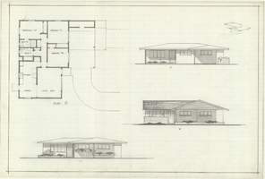
Architectural drawings of residential home in Las Vegas, Nevada, floor plan and three elevations, 1955
Date
Archival Collection
Description
Floor plan with three different front exterior elevations for a ranch-style residential home in the Greater Las Vegas development in Las Vegas, Nevada. Floor plan is labeled "Plan 11," and elevations are labeled A,B and C.
Site Name: Greater Las Vegas
Image