Search Results
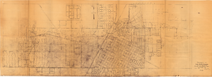
Topographic map of Las Vegas Rancho, showing location of wells and water lines, Las Vegas, Nev., October 18, 1946
Date
1946-10-18
Archival Collection
Description
'May 1, 1940. Revised Oct. 18, 1946.' 'F-225.' Relief shown by contours. Scale [ca. 1:7,200] 1 in.=600 feet.
Image
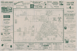
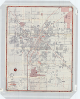
Street map of the city of Las Vegas, 1954
Date
1954
Description
22 x 34 cm. on sheet 36 x 54 cm. Copyright held by Redwood Publishing Co. Includes advertisements. 1954 [ed.] Street index, map of the Strip and advertisements on verso. Map is irregularly shaped. Original publisher: Redwood Pub. Co..
Image
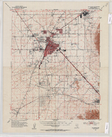
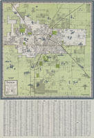
Topographic map of the Las Vegas Valley Area, 1952
Date
1952
Description
Scale 1:62,500 ; polyconic proj ; 1 map : col. ; 45 x 36 cm.; Relief shown by contours and spot heights. Contour interval 20 ft. ; Includes quadrangle location map ; Nevada 15 minute series (topographic) ; Fifteen minute series (topographic) Nevada ; Geological Survey
Image
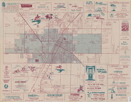
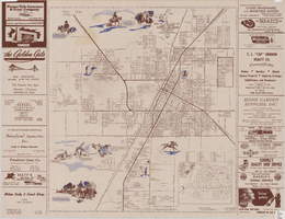
Map of the city of Las Vegas, North Las Vegas, the "Strip", 1957
Date
1957
Description
35 x 50 cm., folded to 22 x 10 cm. 1958 edition. Copyright held by Robert E. Barringer. Panel title: Welcome map, greater Las Vegas area and scenic routes to and from there. "The Raele McCoy Co." Map is irregularly shaped. Index on verso. Includes advertisements for Las Vegas businesses and notes. Birdseye-view map The Las Vegas area : wonderland of the West : on the Old Spanish Trail; advertisements and helpful information on Las Vegas on verso. "1958 edition." Original publisher: Redwood Publishing Co..
Image

Map of the city of Las Vegas, North Las Vegas, the "Strip", 1963
Date
1963
Description
39 x 36 cm., folded to 28 x 15 cm. Panel title: Welcome map, greater Las Vegas area and scenic routes to and from there. Copyright held by Robert E. Barringer. Includes advertisements for Las Vegas businesses, inset of map of Henderson, Nev., and index. Map of California from San Francisco to Los Angeles to Las Vegas by Beth Bergh, advertisements and index on verso Christmas ed. Greater Las Vegas, 1963-1964 ed. Original publisher: Redwood Publishing Co..
Image
Street map of Las Vegas, 1966
Date
1966
Description
1966 ed. Color; 56 x 43 cm., folded to 23 x 10 cm. Panel title: Street map of Las Vegas and vicinity. On bottom of panel: Humble Oil & Refining Company. Index, photographs of Las Vegas scenes and nearby tourist attractions and map titled Lake Mead National Recreation Area, lower basin section on verso. Original publisher: H. M. Gousha Company.
Image
Map of the city of Las Vegas, North Las Vegas, and the "Strip", 1956
Date
1956
Description
40 x 37 cm., folded to 28 x 15 cm. Copyright held by Robert E. Barringer. Panel title: Welcome map, greater Las Vegas area and scenic routes to and from there. Includes inset map of Boulder City. Map of California from San Francisco to Los Angeles to Las Vegas by Beth Bergh on verso. Includes notes. Index on verso. Includes advertisements for Las Vegas and California businesses. Original publisher: Redwood Publishing Co..
Image

Street map of greater Las Vegas, Nevada, 1965-1966
Date
1965 to 1966
Description
Rev. 1965-1966 ed. 55 x 42 cm., folded to 29 x 12 cm. Panel title: Front Boy's official street map. Relief shown by spot heights. Copyright held by Russell A. Meador. Includes notes, quotations and indexes. Street index on verso. "Detailed guide of North Las Vegas, Las Vegas, Paradise Valley, and vicinity." Original publisher: Meador, Russell A.
Image

Map of Las Vegas, Nevada, annotated to show different soil types, September 2, 1948
Date
1948-09-02
Archival Collection
Description
'Types of soil as determined by James M. Montgomery for use in appraisal. (Copy). LRM 7/10/52'--handwritten in blue pencil in lower right corner of map. 'September 2, 1947. Revised September 2, 1948.' Soil was designated as badly corrosive, mildly corrosive, or non-corrosive by hand-drawn colored lines and hand-printed labels. Soil was surveyed to measure its effect on water pipes. Scale [ca. 1:7,200] 1 in.=600 feet.
Image
Map of Las Vegas and vicinity, 1963
Date
1963
Description
42 x 39 cm., folded to 21 x 9 cm. Panel title: Las Vegas and southern Nevada map and street guide. Includes index. Includes illustrations . Advertisement for Nevada State Bank, text with facts about Las Vegas and maps of Henderson, Boulder City and downtown Las Vegas on verso. "Courtesy of Nevada State Bank."--Panel. Original publisher: Thomas Bros. Maps.
Image