Search Results
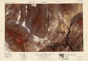
Satellite image map of the Las Vegas Valley, 1981
Date
1981
Description
'1981. Experimental edition 36114-A1-SI-250.' Scale 1:250,000 ; Transverse Mercator proj. (W 116°--W 114°/N 37°--N 36°). Series: Western United States 1:250,000. Western United States 1:250,000 ; NJ 11-12. Filing title: Las Vegas, Nev.; Ariz.; Calif. 'Imagery recorded with Multispectral Scanner (MSS) on NASA Landsat-3.' Includes image coverage diagram. Separate map on verso: Las Vegas / prepared by the U.S. Army Topographic Command ; revised by the U.S. Geological Survey 1969. Ed. 5. Washington, D.C. : Geological Survey, 1976, NJ 11-12 in the series Western United States 1:250,000. United States Geological Survey
Image

City of Las Vegas map, 1952
Date
1952
Description
General information on Las Vegas and index on verso ; Copyright held by Redwood Publishing Co. ; Includes inset map of the Strip (U.S. 91 or Los Angeles Highway) ; Redwood Publishing Company
Text
Map of downtown Las Vegas, Nevada, circa 1952-1955
Date
1952 to 1955
Description
Title in upper left and right margins: Las Vegas, Nevada. Identifies business tenants in the downtown area and includes property valuations, measurements, addresses, etc. Cadastral map. Oriented with north to the lower right.Text, illustrations, aerial photos, and ancillary map of the Las Vegas Strip on verso. Cataloger has determined date of map to be between 1952 and 1955 because the Sahara and the Sands Casinos are shown on the verso of the map, and they both opened in 1952, but the Riviera and the Dunes opened in 1955, and they are not shown on the map. Also, the Hotel Last Frontier is shown on the verso of the map, and its name was changed to New Frontier in 1955. Note: Many of the property names and addresses are erroneous when compared to Las Vegas business directories from the same period.
Image
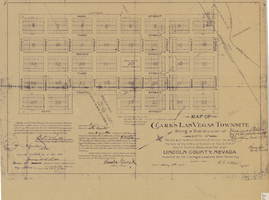
Map of Clark's Las Vegas Townsite, May 8, 1905
Date
1905-05-08
Archival Collection
Description
'Book 1, Page 37.' 'Dated: May 8th, 1905.' Subtitle: 'Being a sub-division of parts of the W.1/2 and the W.1/2 of the N.E.1/4 of Section 34 and the S.1/2 of the S.W.1/4 of Section 27 T.20 S.R. 61 E, Mount Diablo Base and Meridian, Lincoln County, Nevada. A Plat map. Blueline print. Scale [ca. 1:2,400]. 1 in. to 200 feet.
Text
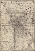
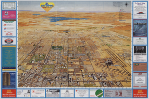
Map of Las Vegas Valley area, 1969
Date
1969
Description
'Featuring Las Vegas ... North Las Vegas ... Paradise Valley.' '1969 edition - revised' -- top of map. Original publisher: Front-Boy Service Co. 1969 ed. Scale [ca. 1:79,200]. 'Copyright - Russell A. Meador, 1968.' Front panel title: 'Front Boy's official 1969 edition street map.' Indexes on map verso. 'Walt Choik, editor, Front Boy Maps' -- back panel.
Text
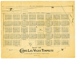
Map of Clark's Las Vegas Townsite, Lincoln County, Nevada, May 10, 1905
Date
1905-05-10
Archival Collection
Description
Scale: 1" = 100'. 1 map ; 28 x 22 cm. Verso of map is an announcement of the auction to be held May 15, 1905, for lots in the Las Vegas townsite. Pricing and lot information is included, as well as specials for railway tickets to Las Vegas from Los Angeles and Salt Like City. Las Vegas Land and Water Company
Text
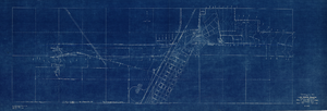
Topographic map of Las Vegas Rancho, showing location of wells and water lines, Las Vegas, Nev., May 1, 1940
Date
1940-05-01
Description
'May 1, 1940.' 'F-225.' Relief shown by contours. Scale [ca. 1:7,200] 1 in.=600 feet. Blueprint.
Image
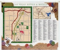
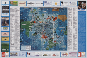
Map of Las Vegas hotels & motels, June 1990
Date
1990-06
Description
Color; 33 x 27 cm. on sheet 46 x 55 cm., folded to 23 x 10 cm. Panel title: Las Vegas area map. Shows locations of hotel and motels in the area of the Strip and Downtown. Also shows locations of country clubs. Includes a separate map of locations of hotels and motels in the surrounding area including North Las Vegas. Includes index. "LVM-75M-6/90."--Verso. Map of locations of golf courses on the verso along with information on points of interest, attractions, general information, tennis, bowling, recreational vehicle parks, and golf.
Image