Search Results
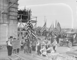
Film transparency of Las Vegas High School, Las Vegas, February 22, 1930
Date
1930-02-22
Archival Collection
Description
Unidentified children carrying flags and signs at the cornerstone-laying ceremony for the new Las Vegas High School in Las Vegas, Nevada.
Image
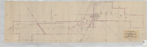
Map showing contemplated improvements to develop the Las Vegas Ranch at Las Vegas, Nevada
Date
1926-03-09
Description
Shows springs, Clark's Las Vegas Townsite, Buck's Addition, cemetery, and State Experimental Farm. Shows township and range lines. From the Union Pacific Collection. Written on the map: "Union Pacific System, Los Angeles & Salt Lake Railroad Co., Map showing contemplated improvements to develop the Las Vegas Ranch at Las Vegas, Nev. Scale 1" - 800" Dwg. No. 31171. Office of Asst. Chief Engr., L.A.&S.L.R.R. Los Angeles, Calif., March 9, 1926. Approved: "
Image
The Wheel Las Vegas Rotary Club newsletter, 1960s-1970s
Date
1960 to 1979
Archival Collection
Description
Newsletter issued by the Las Vegas Rotary Club
Text
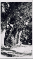
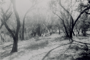
Transparency of Las Vegas Ranch, Las Vegas, circa early 1900s
Date
1900 to 1939
Archival Collection
Description
A view of the Las Vegas Ranch in Las Vegas, Nevada. Site Name: Las Vegas Ranch (Las Vegas, Nev.)
Image
Transparency of Las Vegas Ranch, Las Vegas, circa early 1900s
Date
1900 to 1939
Archival Collection
Description
A view of the Las Vegas Ranch in Las Vegas, Nevada. Site Name: Las Vegas Ranch (Las Vegas, Nev.)
Image
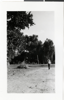
Photograph of Las Vegas Ranch, Las Vegas, circa 1930s
Date
1930 to 1939
Archival Collection
Description
Black and white image of a man with a pipe and umbrella walking down a road at the "Old Las Vegas Ranch." This picture was identified by Shirley Ferron Swanson on October 25, 1983. Site Name: Las Vegas Ranch (Las Vegas, Nev.)
Image
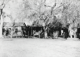
Photograph of Las Vegas Ranch, Las Vegas, circa 1900-1926
Date
1900 to 1926
Archival Collection
Description
The view of homes at the Las Vegas Ranch in Las Vegas, Nevada. Site Name: Las Vegas Ranch (Las Vegas, Nev.)
Image
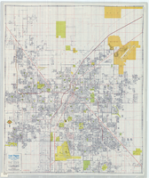
Street map of Las Vegas, North Las Vegas and vicinity, circa 1979
Date
1979
Description
Color; 88 x 73 cm., folded to 24 x 10 cm. "C6-87." Panel title: Las Vegas. Also shows Nellis Air Force Base. Indexes on verso. "Cartographic Department copyright 1979 by California State Automobile Association." Original publisher: California State Automobile Association. Cartographic Department. Scale: One kilometer = 5/8 mile
Image
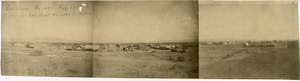
Panoramic view of Clark's Las Vegas Townsite, Las Vegas (Nev.), 1905
Date
1905
Archival Collection
Description
Three photographs placed together to create a panoramic view of Clark's Las Vegas Townsite.
Caption: Los [sic] Vegas Nevada, Aug 1905 from Salt Lake Depot then under construction
Caption: Los [sic] Vegas Nevada, Aug 1905 from Salt Lake Depot then under construction
Image
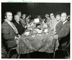
Photograph of the Las Vegas Press Club Installation at the Sands Hotel in Las Vegas, circa April 1969
Date
1969-04
Archival Collection
Description
Kevin Thomas (Los Angeles Times), Philip Scheuer (Los Angeles Times), Mr. and Mrs. Max [Halkoff?] (D.I. Publicity), Mr. and Mrs. Perry Phillips (Oakland Tribune), CRX guests-Miller (the man and woman across the table were also with them), Frank Raffetto (Dallas Morning News), and Mr. and Mrs. Eddie Louie (Los Angeles Herald Examiner) at the Las Vegas Press Club event at the Sands Hotel in Las Vegas, Nevada.
Image