Search Results

Photograph of Las Vegas High School Rhythmettes, Las Vegas, 1959
Date
1959
Archival Collection
Description
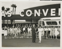
The Las Vegas High School Rhythmettes departing for their Idaho tour from the Las Vegas Convention Center in Las Vegas, Nevada. In the foreground, Las Vegas Mayor Oran Gragson shakes hands with Evelyn Stuckey, the founder and director of the group. This image was taken in the summer of 1959.
Image
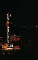
Slide of the Las Vegas Club, Las Vegas, December 1955
Date
1955-12
Archival Collection
Description
Las Vegas Club signs lit up at night on Fremont Street.
Image

Map of the city of Las Vegas, North Las Vegas, "the Strip," 1960
Date
1960
Description
1960 edition. 41 x 43 cm. Copyright held by Robert E. Barringer. Title in upper-right corner of map: Las Vegas area map. Irregularly-shaped map. Includes index, notes, list of Las Vegas schools and inset maps of East Las Vegas (Whitney) and Wherry housing area on Nellis Air Force Base. Original publisher: Redwood Publishing Co..
Image
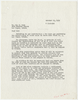
Letter from Las Vegas Land and Water Company (Las Vegas) to Mr. Rex N. Moss (Las Vegas), October 23, 1952
Date
1952-10-23
Archival Collection
Description
Letter regarding the installation of new water lines for a new subdivision in Las Vegas.
Text
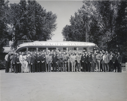
Photograph of the Las Vegas Rotary Club, Las Vegas, 1940
Date
1940
Archival Collection
Description
A black and white image of Las Vegas Rotary Club members in front of a Union Pacific Stages bus in Las Vegas. This photo was taken from a time capsule in the cornerstone of the Union Pacific Railroad station located in Las Vegas. The time capsule was placed there in 1940 and was later retrieved when the building was demolished around 1970.
Image

Map showing general geology and areas of artesian flow of the Las Vegas, Pahrump, and Indian Spring Valleys, Clark and Nye Counties, Nevada, 1946
Date
1947
Description
'United States Department of Interior, Geological Survey, Water Resources Bulletin No. 6.' 'State Engineer of Nevada.' Relief shown by contours. Includes township and range lines. Scale [ca. 1:126,720. 1 in.=approx. 2 miles]. Series: Water resources bulletin (Carson City, Nev.)no. 6. Originally published as plate 1 in Ground water in Las Vegas, Pahrump, and Indian Spring Valleys, Nevada : a summary / G. B. Maxey and T. W. Robinson, prepared in cooperation with the United States Department of the Interior, Geological Survey, and published as no. 6 of the Water resources bulletin.
Image
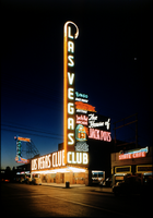
Slide of the Las Vegas Club at night, Las Vegas, circa 1940s
Date
1940 to 1949
Archival Collection
Description
A color slide of the Las Vegas Club sign in Las Vegas, Nevada illuminated at night with views of the club.
Image
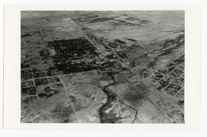
Aerial photograph of McWilliams' Original Las Vegas Townsite and Clark's Las Vegas Townsite, Las Vegas (Nev.), 1931
Date
1931
Archival Collection
Description
Aerial view looking southwest with the original Las Vegas town site, McWilliams' Townsite on the right and the next development in the valley, Clark's Las Vegas Townsite in the left center.
Image
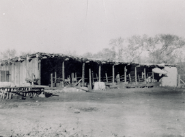
Transparency of Las Vegas Ranch, Las Vegas, 1909
Date
1909
Archival Collection
Description
The stable at the Las Vegas Ranch in Las Vegas, Nevada.
Image
Photograph of Las Vegas High School Rhythmettes, Las Vegas, 1959
Date
1959
Archival Collection
Description
The Las Vegas High School Rhythmettes wave good-bye prior to their departure on a tour to Idaho during the summer of 1959. In the foreground and shaking hands are Mayor Oran Gragson (center foreground, left) and Evelyn Stuckey (center foreground, right), director of the group. They are all standing in front of the Las Vegas Convention Center in Las Vegas, Nevada.
Image