Search the Special Collections and Archives Portal
Search Results

Las Vegas City Ordinances, July 18, 1911 to March 31, 1933
Date
1911-07-18 to 1933-03-31
Archival Collection
Description
Bound volume of Las Vegas City Ordinances, July 18, 1911 to March 31, 1933
Text

The Wheel of Rotary Las Vegas Rotary Club newsletter, July 14, 1949
Date
1949-07-14
Archival Collection
Description
Newsletter issued by the Las Vegas Rotary Club
Text
#69794: Images of sundown/sunset on the Las Vegas Strip made July 8, 2014 in Las Vegas, 2014 July 08
Level of Description
File
Archival Collection
University of Nevada, Las Vegas Creative Services Records (2010s)
To request this item in person:
Collection Number: PH-00388-05
Collection Name: University of Nevada, Las Vegas Creative Services Records (2010s)
Box/Folder: Digital File 00
Collection Name: University of Nevada, Las Vegas Creative Services Records (2010s)
Box/Folder: Digital File 00
Archival Component
Julie Weintraub, Las Vegas, Nevada, 1977
Level of Description
File
Archival Collection
North Las Vegas Library Photograph Collection on North Las Vegas, Nevada
To request this item in person:
Collection Number: PH-00277
Collection Name: North Las Vegas Library Photograph Collection on North Las Vegas, Nevada
Box/Folder: Folder 39
Collection Name: North Las Vegas Library Photograph Collection on North Las Vegas, Nevada
Box/Folder: Folder 39
Archival Component
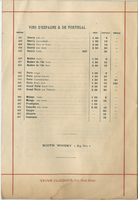
Restaurant Paillard, alcoholic beverage list, July 1896
Date
1896-07
Archival Collection
Description
Menu insert: Spirits lists; Wine lists Restaurant: Restaurant Paillard Location: 38 Boulevard des Italiens et 2 Chaussée d'Antin, Paris, France
Text
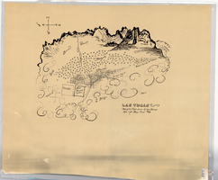
Hand-drawn map of Las Vegas, Nevada, circa 1855
Date
1850 to 1859
Description
Not drawn to scale. Relief shown pictorially. Facsimile of manuscript map. Oriented with north to left. Shows Las Vegas Mormon Fort, desert, mountains.
Image

Map of Las Vegas, Nevada, annotated to show different soil types, September 2, 1948
Date
1948-09-02
Archival Collection
Description
'Types of soil as determined by James M. Montgomery for use in appraisal. (Copy). LRM 7/10/52'--handwritten in blue pencil in lower right corner of map. 'September 2, 1947. Revised September 2, 1948.' Soil was designated as badly corrosive, mildly corrosive, or non-corrosive by hand-drawn colored lines and hand-printed labels. Soil was surveyed to measure its effect on water pipes. Scale [ca. 1:7,200] 1 in.=600 feet.
Image

Newspaper clipping, Las Vegas Valley water withdrawal keeps even, Las Vegas Review-Journal, July, 21 1948
Date
1948-07-21
Archival Collection
Description
Residents of the Las Vegas Valley were withdrawing water at the same rate as was being recharged.
Text
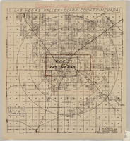
Map showing proposed annexation of Las Vegas Valley, Clark County, Nevada, January 1, 1929
Date
1929-01-01
Description
'Compiled by C. D. Baker, C.E., United States Mineral Surveyor, State Right Water Surveyor, Nevada. Las Vegas, Nev. January 1, 1929. Copyright applied for.' ; "Filed Dec. 10, 1936" and signed by Viola Burns, clerk, city of Las Vegas ; Hand-printed title at top of map: Proposed annexation to Las Vegas ; Map is stamped as Filed Dec 10, 1936 and signed by Las Vegas City Clerk Viola Burns. Library's copy has brown line hand-drawn around area to be annexed.
Image
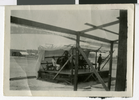
Photograph of Judge Henry M. Lillis in Las Vegas, Nevada, July 4, 1907
Date
1907-07-04
Archival Collection
Description
People at a table with chairs on a partially covered platform. Description given with photograph: "Judge Lillis-1907, 4th of July, Early Las Vegas"
Image
Pagination
Refine my results
Content Type
Creator or Contributor
Subject
Archival Collection
Digital Project
Resource Type
Year
Material Type
Place
Language
Records Classification
