Search Results
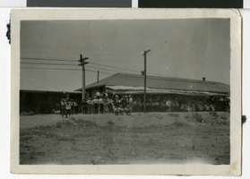
Photograph of people outside of a railroad depot, Las Vegas, Nevada, July 4, 1910
Date
1910-07-04
Archival Collection
Description
A distant view of people outside a depot in Las Vegas. Handwritten description included with the photo: "1910 July 4."
Image
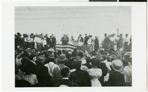
Photograph of 4th of July festivities in Las Vegas, Neava, circa 1910s
Date
1910 to 1919
Archival Collection
Description
Group of people standing with an American flag. "4th of July at railroad depot Early Las Vegas"
Image


Map of Las Vegas and vicinity, Clark County, Nevada, November 1952
Date
1952-11
Description
'Copyright 1950. 3rd issue, November 1952.'
Image

Topographic map of groundwater in the southwest quadrangle of Las Vegas, Nevada, 1985
Date
1985
Description
'Las Vegas Area Map 3Bf.' 'Prepared in cooperation with the U.S. Geological Survey.' ' Water Resources Division, U.S. Geological Survey, Carson City, Nevada.' Scale 1:24,000 (W 115°15´00?--W 115°07´30? / N 36°07´30?--N 36°00´00?). Series: Las Vegas area map ; 3Bf. Urban area maps. Las Vegas area map ; 3Bf. Relief shown by contour lines and spot heights. Title in right and left margins: Las Vegas SW quad : ground water. Title on publications list on Nevada Bureau of Mines and Geology website: Groundwater map of the Las Vegas SW quadrangle. Series: Urban area maps [Las Vegas area map] from list of publications on Nevada Bureau of Mines and Geology website. Nevada Bureau of Mines and Geology
Text

Photograph of the Binion's Casino marquee and entrance, Las Vegas, Nevada, 1979 July
Date
1979-07
Archival Collection
Description
Color photo of Binion's Casino sign - Las Vegas (c. 1970s). Kodak developing stamp on back of photo is dated July 1979.
Image

Street map of the city of Las Vegas & vicinity, showing streets, main roads and recreation areas, 1954
Date
1954
Description
7 maps on 3 sheets, 2 leaves ; 21 x 31 cm. or smaller on sheets 22 x 35 cm. folded to 22 x 13 cm. in paper cover. Title from cover. Copyright held by James E. Stringer. 1st ed. Includes maps of North Las Vegas, the Strip and Vegas Heights and Meadow Acres. Includes key to map coordinates. Includes index. "Map of Las Vegas & Vicinity showing streets, main roads, and recreation areas." Original publisher: R.W. Baldwin.
Image
Proposed structure near Las Vegas, 1954 July 2
Level of Description
File
Scope and Contents
This set includes artist's pencil renderings of interior perspective scenes.
Archival Collection
Homer Rissman Architectural Records
To request this item in person:
Collection Number: MS-00452
Collection Name: Homer Rissman Architectural Records
Box/Folder: Flat File 100
Collection Name: Homer Rissman Architectural Records
Box/Folder: Flat File 100
Archival Component
Maury and Fanny Soss, Las Vegas, 1947 July
Level of Description
File
Archival Collection
Fanny's Dress Shop Photographs
To request this item in person:
Collection Number: PH-00165
Collection Name: Fanny's Dress Shop Photographs
Box/Folder: Folder 01
Collection Name: Fanny's Dress Shop Photographs
Box/Folder: Folder 01
Archival Component
