Search Results
Transcript of interview with John J. Delibos by Claytee D. White, October 2, 2012
Date
Archival Collection
Description
Text
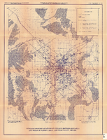
Index map showing locations of geologic sections on plate 2 and wells on plates 2 and 3, Las Vegas Valley, Nevada, 1981 (Open-file report 84-130)
Date
Description
84-130. Originally published as plate 4 of Ground-water conditions in Las Vegas Valley, Clark County, Nevada. Part I. Hydrogeologic framework / by Russell W. Plume, published by the U.S. Geological Survey in 1984 as Open-file report 84-130.
Image
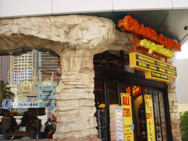
Photographs of Grand Canyon Experience signs, Las Vegas (Nev.), 2002
Date
Archival Collection
Description
Site address: 3791 S Las Vegas Blvd
Sign owner: M H & K Enterprises
Sign details: The Grand Canyon Experience is directly North of the MGM next to the GameWorks complex. Above the clear glass entrances to the outdoor scenic tour's facility is a large building front designed marquee design, as well as a smaller version over the entrance facing northwest.
Sign condition: Structure 5 Surface 3 Lighting 5
Sign form: Fascia
Sign-specific description: The marquee reads Grand Canyon in yellow channel letters outlined in yellow neon, the insides are orange with orange neon in the middle. Experience is spelled in a cursive style orange channel letters with orange neon and incandescent bulbs on the interior. The two texts are supported on a steel framework of interconnecting steel pipes. The shape looks as if it is a bow pointed toward the ground. Two steel poles run vertically approximately 16 feet from the edge of the support system. They run toward the ground against the wall and stop to square i18" tall 10 inch deep, yellow, message box with a black surface. The neon whit von inside of the red channel letters reads "Shop Grand Avenue" in an all caps Arial style text. Two halogen lamps project off of the top of the sign and illuminate a three-dimensional sculpted caricature of a hiker. The entire structure is supported on the West wall of the building. The logo itself spans seventy-eight and a half feet at it's widest and is approximately twenty-three feet tall. Below the NW entrance to the establishment, a smaller version of the giant marquee sign sits above the door. Aluminum channel letters spell " Grand Canyon," with orange argon on the interiors. Below that sits a three-tiered back lit message panel. It forms a shape reminiscent of an upside down step pyramid. The top section actually contains yellow argon in nine-inch cursive text spelling experience. The three stepped cabinet is of a polished aluminum. The text sits on sheet metal raceways.
Sign - type of display: Neon; Incandescent; Backlit
Sign - media: Steel; Fiberglass; Plastic
Sign - non-neon treatments: Paint
Sign animation: Chasing, flashing, oscillating
Notes: The text, which resides on the southern wall and reads "Casino," is filled with incandescent bulbs that all illuminate at the same time, and oscillate. They then shut off at the same time, and then repeat. The raceways of incandescent bulbs chase each other while the neon, which surrounds the back lit, plastic, screens on this wall flash on then off. The bottom two raceways sandwiching the reflective panel chase from left to right, while the remainder of the raceways surrounding the signs, run right to left. The incandescent bulbs on the pylon chase each other gracefully up the length of the pylon. The animation is patterned so as to appear as if a section of several bulbs are pulsing its way up the towers, hugging the edge of the bulbous tops. The raceways continue around the east face of the building. The umbrellas in the plaza behind the pylon, also are animated with incandescent bulbs chasing each other downward along the raceways.
Sign environment: The Grand Canyon Experience is a rather large sign but is dwarfed by the immense MGM pylon just to the south of it. It is accented by faux rock serving as door jambs for the actual entrances.
Sign manufacturer: Mikohn Lighting and Sign
Sign - date of installation: 2000- 08
Sign - thematic influences: The actual theme of the sign is correspondent to that of the business, which the sign advertises. The text does not appear to be associated with any particular theme, but hold a style complimentary to each other. An element of theming is still evident with the faux rock facade, and the sculpted figure on top of the sign.
Sign - artistic significance: If not significant for simply combining different elements to create a completely self-contained sign, it fits into the movement in Las Vegas's history, which is geared more toward the family. The cartoon-like representation of a hiker, the fake rocks, the bright colors, and location in a strip mall, which centered on such establishments as Gameworks and M&M World, all point to the conclusion that families are welcome.
Surveyor: Joshua Cannaday
Survey - date completed: 2002
Sign keywords: Fascia; Neon; Incandescent; Backlit; Steel; Fiberglass; Plastic; Paint
Mixed Content

neo000058-004
Date
Description
Notes: The text fascia sign just to the north of the giant glass display illuminates with a background of neon tubing which chases from right to left. The pattern of colors running across are a sequence banks of red, pink purple and blue vertical neon tubing, chase each other creating a pulsating movement of the individual banks of these colors. While they are animating, the channel letters, which spell "Riviera," are dark and proceed to light up one letter at a time. Once all lit they remain lit, until the background stops with all the bars illuminated. Once all the bars are lit, the interiors of the letters turn off one at a time starting on the far right. The giant mirrored section of the building, advertising for the Splash stage show. The sequence can be best described from its dramatic powering up. The entire sign comes alive with a rapid upward chasing pattern covering the surface of the tower. Once alive, small white bulbs grow out of the end of the space on the top and bottom of the end of the "Splash" text. Once all the previous elements are illuminated, the letters in the Splash logo shut off, illuminate one letter at a time in red neon, then the white neon figure of the seal balancing a ball on the end of it's nose, lights up. The neon bordered circular raceway, then animates with the bulbs in the center chasing each other in a clock-wise sequence. Once lit the vast array of white bulbs grown out of the end of the text begin to gently oscillate, as well as the sparse assortment of floating and attached incandescent bulbs on the wall of the tower. Once the bulbs animate for a few seconds, the entire wall chases downward, becoming black as night, except for the Slash logo text. Underneath the entire front side of the western face of the Riviera, the incandescent bulbs which cover the entire surface oscillate in a wildly, while the ringed entablature on the wall animates quietly in comparison. The multi-colored rings of neon tubing chase each other from left to right, chasing the distance then repeating. The sequence then changes direction and chase from left to right. Creating the tops and bottoms of the entablature are raceways lined with incandescent bulbs that chase each other from left to right. On the surface of the west wall incandescent bulbs chase each other along the raceways which run horizontally around the internally lit cabinets. The small vertical raceways which run inside the clear plastic boxes chase each other from top to bottom, but all the raceways are offset to each other by a few seconds. At the North end of the property the signage for the Riviera's, "Nickeltown" gambling attraction, dominates the corner. He animation on the large exploding sculptural fountain lights up the entire corner. The three rocketing pieces of steel are wrapped in repeating bands of their corresponding colors of blue, purple and yellow. All three simultaneously chase from bottom to top, until completely lit. Then they begin to animate in a chasing pattern from bottom to top. After a few moments of chasing, they chase from beginnig to top once more, leaving al the tubes dark in its path. Along the circular entablature, which runs the circumference of the top mass of the fountain, incandescent bulbs chase each other from right to left, but only on the side which faces the casino. The wall, which faces north, contains the multicolored banks of vertical neon bars that animate in a specific pattern. They chase each other from right to left, then only the purple neon tubing illuminates, they chase again, then only the blue neon tubing illuminates. They chase once again, and then only the gold bars illuminate. The bars chase yet one more time, then all of the tubing illuminates, thus ending the sequence. The main entrance to nickel town is adorned with neon text and images, but only the stars higher up on the wall itself animate. The incandescent bulbs elevated above the surface of the mirrored wall, animate in a soft oscillating pattern, adding the twinkling effect. The larger five pointed stars are animated on the interior by a center of oscillating incandescent bulbs, while concentric neon shapes echo outward in the yellow, purple and blue colors seen on the adjacent wall facing north. The smaller snow-flake esque star shapes are alive with oscillating incandescent bulbs. Looking upward along the north face of the closest tower, the giant vertical, Riviera channel letters animate one character at a time, oscillate then shuts off.
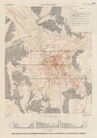
Map and basin profiles showing thickness of valley-fill deposits, Las Vegas Valley, Nevada, 1981 (color variation)
Date
Description
Image
"Minority Involvement and the Hoover Dam Project": manuscript draft by Roosevelt Fitzgerald
Date
Archival Collection
Description
From the Roosevelt Fitzgerald Professional Papers (MS-01082) -- Unpublished manuscripts file.
Text
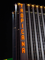
Photographs of Tropicana signs, Las Vegas (Nev.), 2002
Date
Archival Collection
Description
Photos show Tropicana signs at night. Two surveys were conducted to gather information about this sign. One was conducted in 2002 and one was conducted in 2017. PDFs are available for both surveys. See the 2017 survey PDF for additional information that is not included in the object description.
Site name: Tropicana Hotel and Casino (Las Vegas, Nev.)
Site address: 3801 S Las Vegas Blvd
Sign owner: Aztar
Sign details: The southeast corner of Las Vegas Blvd and Tropicana Boulevard belongs to the Tropicana Hotel Casino. The Tropicana is composed of two high-rise towers, the low-rise wings of rooms, and the casino itself. One tower faces southwest/northeast, while the other tower, further east on the property faces southeast/northwest. The expanse of the corner, near the street is an open concrete pedestrian plaza, with rising planters, a large functioning waterfall, also surrounded by foliage, and various vendors. The porte-cochere connects the plaza to the hotel, with the connecting bridge to the Excalibur, residing on top.
Sign condition: Structure 5 Surface 5 Lighting 5
Sign form: Pylon; Fascia
Sign-specific description: On the north and south faces of the porte-cochere roof line, on a pediment between the sloping blue roof and a row of brass fixtures, large channel letters in the faceted Tropicana font, horizontally spell "Tropicana." The exteriors are painted black wit a blue reflective finishing the interiors. They are filled with blue neon. The ceiling of the porte-cochere holds two distinct features to its credit. The north half is adorned with a glass domed hole through the roof. The interior thickness and recessed lip are covered in a polished metallic surface. Seashells adorn the edge where the lip meets the ceiling as well as on the face of the ledge as well. Teal, red and gold organic lines are floating across the surface in paint. The south half of the porte-cochere is covered with six recessed rectangular areas. Within the giant coffering a field of polished metal squares form a tiled field bordered with incandescent bulbs. In each of the corner intersections a sculpted glass cover, hold a single incandescent bulbs. Each field holds forty or so of these bulbs and their coverings. Two identical pylons flank the courtyard. One of them is on the south side of Tropicana avenue facing east /west, while the other faces north/south on the east side of the street. The pylon is essentially a giant double-sided rectangle with a top section that angles back into space on either side to meet at a peak. The result is a small roof like peak at the top of the sign supporting text on its face. The text however is standing up horizontally at a 90-degree angle. Besides the text logo at the top, the sign possesses an internally lit message cabinet on the bottom of the face, a small LED message center, and another backlit cabinet with a color advertisement for Follies Berger. The message center at the bottom is white plastic with vinyl lettering. The small message center is flanked by three steel poles, the height of the sign and finished to look like bamboo. The horizontal line created by the top edge of the sign is also lined with this false bamboo. The channel lettering at the top are polished metallic, shallow channel letters, which extend in depth all the way back to the face of the roof like form. The faces are filled with incandescent bulbs and bordered in neon. The sides of the sign are treated with a vertical bull nose like shape which runs vertically up the width of the sign. It is pointed wit ha triangular shape on both ends. The shape begins flush with the triangular peak of the signs profile and ends with its point approximately halfway down the height of the bottom message center. The bull nose is faceted with three faces. At the triangular tips, the three faces appear to make the space retain a jewel like shape. The middle face is laden with incandescent bulbs. The rest of the width of the sign is also finished in polished gold metal. The remaining open space on the faces of the cabinet, as well as exposed pieces of the cabinet, are painted a teal color. A border on incandescent bulbs runs around the entire face of the signage. The only signage present on the towers , is the on the first tower, closest to the corner. Running vertically down the west side of the southwest face of the tower, giant metallic channel letters spell "Tropicana" and are lined on the interiors with a double row of neon. Along the western end of the tower, three, double rows of incandescent bulbs run the entire height of the building. These animate, chasing each other down, simulating a waterfall.
Sign - type of display: Neon; Incandescent; Backlit; LED
Sign - media: Steel; Plastic
Sign - non-neon treatments: Graphics; Paint
Sign animation: Chasing, oscillating
Notes: Pylons: The incandescent bulbs inside the channel letters for the logo oscillate, as well as on the vertical width of the pylon. The raceways around the backlit screen chase each other, but it is a double row of incandescent bulbs that chase in opposite directions to each other. Building: The giant raceways of incandescent bulbs on the northwest corner of the Tropicana's front tower, chase each other from top to bottom, representing a waterfall.
Sign environment: The Tropicana belongs to one of the four major properties which comprise the intersection of Tropicana Ave. and Las Vegas Blvd The corner is occupied by a plaza and pedestrian element that is also seen in the other neighbors in the intersection as well. The towers loom over the plaza, as is accented by kiosks for patron promotions, and other services such as refreshments. The property is a good example of a property which has adapted over the years to fit and compete with the rapid evolution of Las Vegas.
Sign manufacturer: Original fascia design ( letters on building are what remain after remodel) by Heath and Company. Pylons: by YESCO
Sign designer: Original prismatic design was submitted by AD-Art's Jack DuBois ,but produced by Raul Rodriguez for heath and Company.
Sign - date of installation: 1978
Sign - date of redesign/move: The original facade was remodeled, which altered the exterior of the porte- cochere, but the letters remain.
Sign - thematic influences: The theme surrounding the Tropicana is that of the island paradise. References to the theming, that are evident on the exterior, are the shape and style of the text utilized in the various signage as well as those shapes being carried over into the designs other architectural elements. The blue incandescent bulbs that chase each other down the face of the building obviously reference a waterfall. Juxtaposed to the aesthetic, actual water elements have been incorporated into the front facade also. The angular design of the text is reminiscent of prism like faceted fonts is reminiscent many aspects dealing with Las Vegas, but fit more into the theme of the property than Vegas. The prismatic design is also incorporated into the design of the actual pylon also. The edges of the vertical length of the pylon are faceted and the triangular end seen on the fonts can be found elsewhere on the pylon. Not only is this shape evident with the pylon but on the fascia of the neighboring facade. The peaked rooflines of the village like facade also mirror this shape, being accented by the incandescent bulbs that line the edges. The text are reminiscent of something tropical, the shape somehow represents something rustic and wooden, even a tiki-like flavor.
Surveyor: Joshua Cannaday
Survey - date completed: 2002
Sign keywords: Chasing; Oscillating; Pylon; Fascia; Neon; Incandescent; Backlit; Steel; Plastic; Graphics; Paint; LED
Mixed Content
Descriptions of Native American reservations in Nevada, and Bureau of Indian Affairs requests for transfer of excess property: correspondence
Date
Archival Collection
Description
Correspondence between Joseph Zuni, Nevada Indian Agency, and attorney Thomas L. Leen describing the Las Vegas Paiute Colony and "allotted" vs. "communal" land. Western Nevada Indian Agency description of land acquisition for the Las Vegas Tribe of Paiute Indians. Memorandum to the Commissioner of Indian Affairs from the Chief, Division of Property and Supply Management, on the subject of real property acquisition "by the Bureau for use by Indian Tribes or groups." Letter from Commissioner Thomas M. Thawley to Assistant Secretary of the Interior Richard S. Bodman about requests from the Bureau of Indian Affairs for transfer of excess real property. Letter from Assistant Director Paul H. O'Neill to Commissioner Thomas H. Thawley "concerning the use of excess real property for various Indian programs." Letter from Thomas M. Thawley to Commissioner Louis R. Bruce about pending requests to the General Services Administration (GSA) for the transfer of excess real property. Transfer requests from Bureau of Indian Affairs with descriptions of property requested and proposed use. Letter from Assistant Director Paul H. O'Neill to Thomas M. Thawley about pending excess real property transfer requests. Correspondence between Teaching Assistant Elizabeth Warren and the Nevada Indian Agency asking about the history of reservations in Nevada.
Text