Search the Special Collections and Archives Portal
Search Results
New York Deli, 1985
Level of Description
File
Archival Collection
JMA Architecture Studio Records
To request this item in person:
Collection Number: MS-00783
Collection Name: JMA Architecture Studio Records
Box/Folder: Box 89
Collection Name: JMA Architecture Studio Records
Box/Folder: Box 89
Archival Component
New York Branch, undated
Level of Description
File
Archival Collection
International Food Service Executives Association Records
To request this item in person:
Collection Number: MS-00305
Collection Name: International Food Service Executives Association Records
Box/Folder: Box 042 (Restrictions apply)
Collection Name: International Food Service Executives Association Records
Box/Folder: Box 042 (Restrictions apply)
Archival Component
New York Medley, undated
Level of Description
File
Archival Collection
Connie Atkinson Collection of Sheet Music and Music Scores
To request this item in person:
Collection Number: MS-00560
Collection Name: Connie Atkinson Collection of Sheet Music and Music Scores
Box/Folder: Oversized Box 23
Collection Name: Connie Atkinson Collection of Sheet Music and Music Scores
Box/Folder: Oversized Box 23
Archival Component
New York: Buffalo, 1998
Level of Description
File
Archival Collection
Imperial Royal Sovereign Court of the Desert Empire Records
To request this item in person:
Collection Number: MS-00556
Collection Name: Imperial Royal Sovereign Court of the Desert Empire Records
Box/Folder: Box 01
Collection Name: Imperial Royal Sovereign Court of the Desert Empire Records
Box/Folder: Box 01
Archival Component

Chart showing water consumption by month in Las Vegas in 1938, circa 1939
Date
1939 (year approximate)
Archival Collection
Description
1938 Las Vegas water consumption by month showing a daily average per month.
Transcribed Notes: Handwritten numbers on the sheet
Text
127 New York, 1990s
Level of Description
File
Archival Collection
Culinary Workers Union Local 226 Las Vegas, Nevada Photographs
To request this item in person:
Collection Number: PH-00382
Collection Name: Culinary Workers Union Local 226 Las Vegas, Nevada Photographs
Box/Folder: Box 25
Collection Name: Culinary Workers Union Local 226 Las Vegas, Nevada Photographs
Box/Folder: Box 25
Archival Component

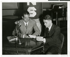
Photograph of Howard Hughes and Clifford Adams in WINS radio station, New York, New York, January 16, 1936
Date
1936-01
Archival Collection
Description
Howard Hughes (left) and Clifford Adams at microphone of Station WINS in New York City.
Image
York Street 1929, 2005
Level of Description
File
Archival Collection
Guide to the Canadian Film Centre Worldwide Short Film Festival Submissions
To request this item in person:
Collection Number: MS-00615
Collection Name: Guide to the Canadian Film Centre Worldwide Short Film Festival Submissions
Box/Folder: Box 2005-010
Collection Name: Guide to the Canadian Film Centre Worldwide Short Film Festival Submissions
Box/Folder: Box 2005-010
Archival Component

Photograph of mechanics with the Lockheed 14 aircraft, July 10, 1938
Date
1938-07-10
Archival Collection
Description
The black and white, wide view of the Lockheed 14 plane being fueled by mechanics via the Colonial Beacon Oil Co, Inc.
Image
Broadway during the ticker-tape reception accorded Howard Hughes and his four crew members in recognition of their around-the-world flight, 1938 July 15
Level of Description
File
Archival Collection
Howard Hughes Public Relations Photograph Collection
To request this item in person:
Collection Number: PH-00373
Collection Name: Howard Hughes Public Relations Photograph Collection
Box/Folder: Folder 12
Collection Name: Howard Hughes Public Relations Photograph Collection
Box/Folder: Folder 12
Archival Component
Pagination
Refine my results
Content Type
Creator or Contributor
Subject
Archival Collection
Digital Project
Resource Type
Year
Material Type
Place
Language
Records Classification
