Search Results

Photograph of Howard Hughes at Grover Whalen's house, New York, 1938
Date
1938
Archival Collection
Description
A candid photograph of Howard Hughes at Grover Whalen's house.
Image
Photograph of Howard Hughes at Grover Whalen's house, New York, 1938
Date
1938
Archival Collection
Description
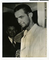
A bust view of Howard Hughes at Grover Whalen's house.
Image

Photograph of Howard Hughes at Grover Whalen's house, New York, 1938
Date
1938
Archival Collection
Description
A close up of Howard Hughes, at Grover Whalen's house.
Image
Photograph of Howard Hughes news conference, New York, April, 1947
Date
1947-04
Archival Collection
Description
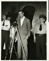
Howard Hughes at a press conference, standing in front of what is thought to be a DC-3.
Image

Photograph of the landing of Howard Hughes' Lockheed 14 aircraft, New York, July 14, 1938
Date
1938-07-14
Archival Collection
Description
The black and white, aerial view of Howard Hughes' Lockheed 14 aircraft preparing for its final landing on its Round the World flight in Floyd Bennett Field, New York.
Image

Photograph of the landing of Howard Hughes' Lockheed 14 aircraft, New York, July 14, 1938
Date
1938-07-14
Archival Collection
Description
The black and white, aerial view of Howard Hughes' Lockheed 14 aircraft after performing its final landing on the Round the World flight at Floyd Bennett Airport, New York.
Image
Slides of 20th century cities and buildings including Frank Lloyd Wright's studio, home, and architectural projects; examples of International and modernist style architecture including Le Corbusier's La Ville Contemporaine; Egyptian pyramids and tombs; General Motors exhibit at the 1964 New York World's Fair; New York-New York Hotel and Casino; Sydney Opera House; and the National Congress of Chile building, 1984
Level of Description
File
Archival Collection
Frank Reynolds Professional Papers
To request this item in person:
Collection Number: MS-00926
Collection Name: Frank Reynolds Professional Papers
Box/Folder: Box 02 (Restrictions apply)
Collection Name: Frank Reynolds Professional Papers
Box/Folder: Box 02 (Restrictions apply)
Archival Component
T-Shirt Color: Navy Blue; Front: FDNY; Back: Dedicated To Those Who Have Made The Ultimate Sacrifice Fire Department City Of New York FDNY, City Of New York FDNY Shield; Handwritten Text: You'll Never Be Forgotten God Bless You Scott 7 Karl Miller 9-11-99 La County PD, approximately 2001-2012
Level of Description
File
Archival Collection
New York-New York Hotel and Casino 9-11 Heroes Tribute Collection
To request this item in person:
Collection Number: MS-00459
Collection Name: New York-New York Hotel and Casino 9-11 Heroes Tribute Collection
Box/Folder: Box 440
Collection Name: New York-New York Hotel and Casino 9-11 Heroes Tribute Collection
Box/Folder: Box 440
Archival Component
T-Shirt Color: Navy Blue; Front: 13th Precinct City Of New York Police 9-11-01 Truck One, Police Badge; Back: N.Y.P.D., P.O. Robert Fazio, P.O. Moira Smith, P.O. Brian McDonnell In Memory Of Our Fallen Heroes 9-11-01, New York City Outline And American Flags, approximately 2001-2012
Level of Description
File
Archival Collection
New York-New York Hotel and Casino 9-11 Heroes Tribute Collection
To request this item in person:
Collection Number: MS-00459
Collection Name: New York-New York Hotel and Casino 9-11 Heroes Tribute Collection
Box/Folder: Box 34
Collection Name: New York-New York Hotel and Casino 9-11 Heroes Tribute Collection
Box/Folder: Box 34
Archival Component
Photograph of Howard Hughes giving a news conference next to his DC-3, New York, 1947
Date
1947-04
Archival Collection
Description
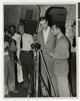
Howard Hughes giving a news conference beside his airplane after landing in New York. This was his first flight after the nearly fatal XF-11 prototype crash in 1946.
Image