Search Results
Howard Hughes and Mayor Fiorello La Guardia seated in an automobile that was used in a parade dedicated to Hughes's completion of his around-the-world flight in New York City, 1938 July 15
Level of Description
File
Archival Collection
Howard Hughes Public Relations Photograph Collection
To request this item in person:
Collection Number: PH-00373
Collection Name: Howard Hughes Public Relations Photograph Collection
Box/Folder: Folder 13
Collection Name: Howard Hughes Public Relations Photograph Collection
Box/Folder: Folder 13
Archival Component
New York: Bonifacio, Philip, "Social Impact of Legalized Casino Gambling"; Volberg, Rachel A., "Gambling and Problem Gambling Among Adolescents in New York"; and Jonathan Taylor's talking points regarding socioeconomic impact of casino in Sullivan County, New York, approximately 1979-2001
Level of Description
File
Archival Collection
Katherine A. Spilde Papers on Native American Gaming
To request this item in person:
Collection Number: MS-00092
Collection Name: Katherine A. Spilde Papers on Native American Gaming
Box/Folder: Box 15
Collection Name: Katherine A. Spilde Papers on Native American Gaming
Box/Folder: Box 15
Archival Component
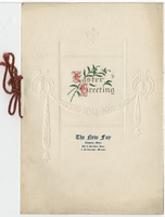
The New Fay Easter dinner menu, Sunday, April 7, 1912
Date
1912-04-07
Archival Collection
Description
Restaurant: The New Fay (Virginia, Minn.) Location: Virginia, Minnesota, United States
Text
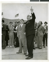
Photograph a crowd awaiting watching Howard Hughes land, New York, July 14, 2013
Date
1938-07-14
Archival Collection
Description
The black and white view Mayor Laguardia and Grover Whelen watched Howard Hughes land in his Lockheed 14 aircraft at Floyd Bennett Field, New York. Typed onto a piece of paper attached to the image: "Mayor Laguardia (left) and Grover Whelen looking skyward as they see the approaching Howard Hughes and his globe girdlers complete A Round The World flight, 7-24-38. (Press Association)."
Image
New York University Graduate School of Business Administration, "A Study of the Economic Impact of the Change in the Pari-mutuel Tax on the Pari-mutuel Industry of New York State", 1980
Level of Description
File
Archival Collection
Eugene Martin Christiansen Papers
To request this item in person:
Collection Number: MS-00561
Collection Name: Eugene Martin Christiansen Papers
Box/Folder: Box 085
Collection Name: Eugene Martin Christiansen Papers
Box/Folder: Box 085
Archival Component

Map of California, with territories of Utah, Nevada, Colorado, New Mexico, and Arizona, 1864
Date
1864
Description
40 x 62 cm. Relief shown by hachures. Prime meridians: Greenwich and Washington. Page numbers at top: 58-59. "Entered according to act of Congress in the year 1864 by A. J. Johnson in the Clerk's Office of the District Court of the United States for the Southern District of New York." Original publisher: Johnson and Ward.
Image
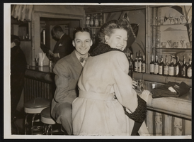
Photograph of Donn Arden at the Ubangi Club, New York (N.Y.), 1940s
Date
1940 to 1949
Archival Collection
Description
Donn Arden (left) at the Ubangi Club with unidentified woman.
Image
Howard Hughes in New York beside the Northrop Gamma Racer at the Floyd Bennett Airport after breaking the record from Miami to New York speed record, 1936
Level of Description
File
Archival Collection
Howard Hughes Public Relations Photograph Collection
To request this item in person:
Collection Number: PH-00373
Collection Name: Howard Hughes Public Relations Photograph Collection
Box/Folder: Folder 01
Collection Name: Howard Hughes Public Relations Photograph Collection
Box/Folder: Folder 01
Archival Component
Ford W. Harris and Metro-Goldwyn-Mayer Pictures New York, New York regarding similarities in parrot logo trademark, 1931 November 05 to 1931 December 03
Level of Description
File
Archival Collection
Howard Hughes Film Production Records
To request this item in person:
Collection Number: MS-01036
Collection Name: Howard Hughes Film Production Records
Box/Folder: Box 488 (Restrictions apply)
Collection Name: Howard Hughes Film Production Records
Box/Folder: Box 488 (Restrictions apply)
Archival Component

Map of California, Utah, Nevada, Colorado, New Mexico and Arizona, 1864
Date
1864
Description
'Johnson's California, also Utah, Nevada, Colorado, New Mexico, and Arizona, published by A.J. Johnson, New York.' 'Entered according to Act of Congress in the Year 1864, by A.J. Johnson in the Clerks Office of the District Court of the United States for the Southern District of New York.' Atlas page numbers in upper margin: 66-67. Relief shown by hachures. Prime meridians: Greenwich and Washington, D.C. Shows proposed railroads, locations of Indian tribes, natural features, counties, mines, mail routes, trails and routes of exploring expeditions. On verso: History and statistics of Mexico and Central America and statistics of national finances and the Post Office of the United States, 1860. Scale [ca. 1:3,484,800. 1 in. to ca. 55 miles] (W 123°--W 103°/N 42°--N 32°)
Text