Search Results
Howard Hughes in New York beside the Northrop Gamma Racer at the Floyd Bennett Airport after breaking the record from Miami to New York speed record, 1936
Level of Description
File
Archival Collection
Howard Hughes Public Relations Photograph Collection
To request this item in person:
Collection Number: PH-00373
Collection Name: Howard Hughes Public Relations Photograph Collection
Box/Folder: Folder 01
Collection Name: Howard Hughes Public Relations Photograph Collection
Box/Folder: Folder 01
Archival Component
Ford W. Harris and Metro-Goldwyn-Mayer Pictures New York, New York regarding similarities in parrot logo trademark, 1931 November 05 to 1931 December 03
Level of Description
File
Archival Collection
Howard Hughes Film Production Records
To request this item in person:
Collection Number: MS-01036
Collection Name: Howard Hughes Film Production Records
Box/Folder: Box 488 (Restrictions apply)
Collection Name: Howard Hughes Film Production Records
Box/Folder: Box 488 (Restrictions apply)
Archival Component
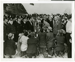
Photograph of Howard Hughes at Floyd Bennett Airfield, New York, July 14, 1938
Date
1938-07-14
Archival Collection
Description
The black and white view of Howard Hughes, surrounded by crowds, as he stands before a microphone after landing his Lockheed 14 aircraft for the Around the World flight at Floyd Bennett Airfield in New York.
Image
New York: Padavan, Frank, "The Dice are Rolling: Gambling with New York State's Future" report; Lynch, Gerald W., "Final Report of the Casino Gambling Study Panel New York State" report; Economic Research Service of the New York State Legislative Institute, "Casino Gambling Study" report; and Task Force on Legalized Gambling, "Easy Money" report, approximately 1974-1997
Level of Description
File
Archival Collection
Katherine A. Spilde Papers on Native American Gaming
To request this item in person:
Collection Number: MS-00092
Collection Name: Katherine A. Spilde Papers on Native American Gaming
Box/Folder: Box 15
Collection Name: Katherine A. Spilde Papers on Native American Gaming
Box/Folder: Box 15
Archival Component
Easterling, D. 1997. "The Vulnerability of the Nevada Visitor Economy to a Respository at Yucca Mountain." Risk Analysis, 17, (5), 635-647. New York, New York: Plenum Press, 1997
Level of Description
File
Archival Collection
Environmental Radiation Protection Standards for Yucca Mountain, Nevada
To request this item in person:
Collection Number: MS-00603
Collection Name: Environmental Radiation Protection Standards for Yucca Mountain, Nevada
Box/Folder: Box 37
Collection Name: Environmental Radiation Protection Standards for Yucca Mountain, Nevada
Box/Folder: Box 37
Archival Component
Brenot, J.; Bonnefous, S.; and Marris, C. 1998. "Testing the Cultural Theory of Risk in France." Risk Analysis. 18 (6). 729-739 New York, New York: Plenum Press, 1998
Level of Description
File
Archival Collection
Environmental Radiation Protection Standards for Yucca Mountain, Nevada
To request this item in person:
Collection Number: MS-00603
Collection Name: Environmental Radiation Protection Standards for Yucca Mountain, Nevada
Box/Folder: Box 29
Collection Name: Environmental Radiation Protection Standards for Yucca Mountain, Nevada
Box/Folder: Box 29
Archival Component

Map of California, Utah, Nevada, Colorado, New Mexico and Arizona, 1864
Date
1864
Description
'Johnson's California, with Utah, Nevada, Colorado, New Mexico, and Arizona, published by Johnson and Ward.' 'Entered according to Act of Congress in the Year 1864 by A.J. Johnson in the Clerks Office of the District Court of the United States for the southern district of New York.' Atlas page numbers in upper margin: 66-67. This is probably plate 67 from Johnson's New Illustrated Family Atlas, published in New York by Johnson & Ward in 1864. Shows natural features, locations of Indian tribes, proposed railroad routes, routes of explorers, trails, county boundaries and populated places ; "." ; Relief shown by hachures ; Prime meridians: Greenwich and Washington ; In top margin: 66-67 ; Hand colored ; On verso: Historical and statistical view of Mexico and central America (p. 79) and Historical and statistical view of the United States, 1860 (p. 78) Scale [ca. 1:3,484,800]. 1 in. to ca. 55 miles (W 124°--W 102°/N 42°--N 32°)
Text
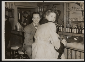
Photograph of Donn Arden at the Ubangi Club, New York (N.Y.), 1940s
Date
1940 to 1949
Archival Collection
Description
Donn Arden (left) at the Ubangi Club with unidentified woman.
Image
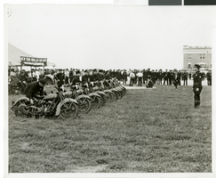
Photograph of the arrival of Howard Hughes' Lockheed 14, New York, July 14, 1938
Date
1938-07-14
Archival Collection
Description
The black and white view of motorcycle police awaiting the arrival of Howard Hughes at Floyd Bennett Field in New York. Typed onto a piece of paper attached to the image: "Motorcycle police on hand for Hughes' landing, New York city -- Motorcycle policemen lined up on Floyd Bennett Field, July 14th, to help keep in check the crowd of 30,000 persons that gathered to greet Howard Hughes and his heroic crew as they landed their giant Lockheed plain after their record-smashing flight around the world. Credit Line (ACME). 7/14/38."
Image
T-Shirt Color: Gray; Front: Detectives Association Inc. Nassau County, New York, Dept. Emblem; Handwritten Text: New York/Nassau Remembers, approximately 2001-2012
Level of Description
File
Archival Collection
New York-New York Hotel and Casino 9-11 Heroes Tribute Collection
To request this item in person:
Collection Number: MS-00459
Collection Name: New York-New York Hotel and Casino 9-11 Heroes Tribute Collection
Box/Folder: Box 29
Collection Name: New York-New York Hotel and Casino 9-11 Heroes Tribute Collection
Box/Folder: Box 29
Archival Component