Search Results
Hiram "Tommy" Thurlow on the Lockheed 14, New York, 1938 July 09
Level of Description
File
Archival Collection
Howard Hughes Public Relations Photograph Collection
To request this item in person:
Collection Number: PH-00373
Collection Name: Howard Hughes Public Relations Photograph Collection
Box/Folder: Folder 05
Collection Name: Howard Hughes Public Relations Photograph Collection
Box/Folder: Folder 05
Archival Component
New York's Day Banquet, menu, Pacific Hotel, 1890 February 22
Level of Description
Item
Archival Collection
Bohn-Bettoni Menu Collection
To request this item in person:
Collection Number: MS-00793
Collection Name: Bohn-Bettoni Menu Collection
Box/Folder: Box 09
Collection Name: Bohn-Bettoni Menu Collection
Box/Folder: Box 09
Archival Component

Map of California and Territories of New Mexico and Utah, 1862
Date
1862
Description
Scale [ca. 1:3,231,360. 1 in. to approx. 51 miles] (W 125°00--W 103°30/N 42°00--N 31°45) ; 1 map : hand col. ; 40 x 60 cm., on sheet 46 x 68 cm ; Relief indicated by hachures and spot heights ; Prime meridians: Greenwich and Washington, D.C ; Decorative border ; Hand colored ; Atlas p. numbers in upper margin: 58-59 ; Date est. from territorial borders and county configuration ; Shows natural features, locations of Indian tribes, proposed railroad routes, routes of explorers, trails, county boundaries and populated places ; Johnson and Ward
Image
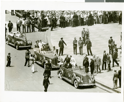
Photograph of a parade for Howard Hughes, New York City, July 15, 1938
Date
1938-07-15
Archival Collection
Description
Typed onto a piece of paper attached to the image: "Howard Hughes and his crew arriving at the City Hall after their Round-The-World flight. July 1938."
Image
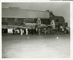
Photograph of people surrounding the Lockheed 14 aircraft, New York, July 9, 1938
Date
1938-07-09
Archival Collection
Description
The black and white view of unidentified people surrounding the Lockheed 14 aircraft. Typed on a piece of paper attached to the image: "Rolling Howard Hughes' plane out of hangar at Floyd Bennett Field, with Lt. Thomas Thurlow, one of the navigators, calibrating the compass. 7/9/38."
Image
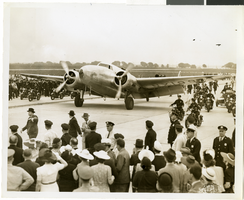
Photograph of the landing of Howard Hughes' Lockheed 14 aircraft, New York, July 14, 1938
Date
1938-07-14
Archival Collection
Description
The black and white view of Howard Hughes' Lockheed 14 aircraft performing its final landing on the Round the World flight at Floyd Bennett Airport, New York. Typed onto a piece of paper attached to the image: "Scene at Floyd Bennett Field as Howard Hughes and his crew landed after completing a round the world flight..... 7-14-38. (Press Association)"
Image

Photograph of the landing of Howard Hughes' Lockheed 14 aircraft, New York, July 14, 1938
Date
1938-07-14
Archival Collection
Description
The black and white, view of Howard Hughes' Lockheed 14 aircraft performing its final landing on the Round the World flight at Floyd Bennett Airport, New York. Typed onto a piece of paper attached to the image: "Scene at Floyd Bennett Field as Howard Hughes and his crew landed after completing a round the world flight..... 7-14-38. (Press Association)"
Image
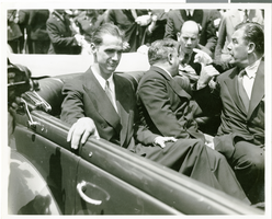
Photograph of Howard Hughes at his parade for Round the World flight, New York City, July 15, 1938
Date
1938-07-15
Archival Collection
Description
The black and white view of Howard Hughes, Mayor La Guerdia, and Grover Whalen leaving City Hall through a parade dedicated to the completion of Hughes' Round the World flight in New York City, New York.
Image
Howard Hughes receives congratulations from New York Mayor Fiorello La Guardia at Floyd Bennett Airport in Brooklyn, New York; also featured is Grover Whalen, 1938 July 12
Level of Description
File
Archival Collection
Howard Hughes Professional and Aeronautical Photographs
To request this item in person:
Collection Number: PH-00321
Collection Name: Howard Hughes Professional and Aeronautical Photographs
Box/Folder: Folder 06
Collection Name: Howard Hughes Professional and Aeronautical Photographs
Box/Folder: Folder 06
Archival Component