Search Results
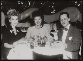
Photograph of Donn Arden at La Martinique, New York (N.Y.), 1940s-1950s
Date
1940 to 1959
Archival Collection
Description
Donn Arden (right) at La Martinique Nightclub with two unidentified women.
Image

Map of California, and territories of Utah, Nevada, Colorado, New Mexico and Arizona, 1864
Date
1864
Description
'Johnson's California, also Utah, Nevada, Colorado, New Mexico, and Arizona, published by A.J. Johnson, New York.' 'Entered according to act of Congress in the year 1864, by A.J. Johnson in the Clerks Office of the District Court of the United States for the southern district of New York.' Atlas page numbers in upper margin: 67-68. Relief shown by hachures. Prime meridian: Greenwich and Washington. Shows natural features, locations of Indian tribes, proposed railroad routes, routes of explorers, trails, county boundaries and populated places. Hand colored. On verso: 'Historical and statistical view of the West India Islands or Columbian Archipelago' (p. 80) and 'Historical and statistical view of Mexico and Central America' (p. 79). Scale [ca. 1:3,484,800]. 1 in. to ca. 55 miles (W 124°--W 102°/N 42°--N 32°).
Text
New York: American Casino Guide listing; agenda for New York Gaming Summit; and newspaper articles on video lottery terminals, sales tax, and internet gaming, approximately 1998-2002
Level of Description
File
Archival Collection
Katherine A. Spilde Papers on Native American Gaming
To request this item in person:
Collection Number: MS-00092
Collection Name: Katherine A. Spilde Papers on Native American Gaming
Box/Folder: Box 15
Collection Name: Katherine A. Spilde Papers on Native American Gaming
Box/Folder: Box 15
Archival Component
Salk, M. S.; Tolbert, V.R.; and Dickerman, J.A. 1999. "Guidelines and Techniques for Improving the NEPA Process." Environmental Management. 23, (4). 467-476. New York, New York: Springer-Verlag, 1999
Level of Description
File
Archival Collection
Environmental Radiation Protection Standards for Yucca Mountain, Nevada
To request this item in person:
Collection Number: MS-00603
Collection Name: Environmental Radiation Protection Standards for Yucca Mountain, Nevada
Box/Folder: Box 44
Collection Name: Environmental Radiation Protection Standards for Yucca Mountain, Nevada
Box/Folder: Box 44
Archival Component
Davies. J. B., and C. B. Archambeau, 1997, "Geohydrological models and earthquake effects at Yucca Mountain, Nevada," Environmental Geology, Volume 32. Number 1. pp. 23-35. New York, New York, 1997
Level of Description
File
Archival Collection
Environmental Radiation Protection Standards for Yucca Mountain, Nevada
To request this item in person:
Collection Number: MS-00603
Collection Name: Environmental Radiation Protection Standards for Yucca Mountain, Nevada
Box/Folder: Box 05
Collection Name: Environmental Radiation Protection Standards for Yucca Mountain, Nevada
Box/Folder: Box 05
Archival Component
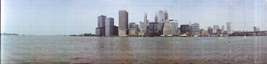
Lower Manhattan from Brooklyn Pier, New York: panoramic photographs
Date
1981-05-25
Archival Collection
Description
From the Bob Paluzzi Panoramic Photographs
Image

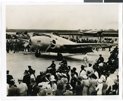
Photograph of the landing of Howard Hughes' Lockheed 14 aircraft, New York, July 14, 1938
Date
1938-07-14
Archival Collection
Description
The black and white view of Howard Hughes' Lockheed 14 aircraft performing its final landing on the Round the World flight at Floyd Bennett Airport, New York. Typed onto a piece of paper attached to the image: "Howard Hughes lands at Floyd Bennett Field. 7/38."
Image
Photograph of the landing of Howard Hughes' Lockheed 14 aircraft, New York, July 14, 1938
Date
1938-07-14
Archival Collection
Description
The black and white view of Howard Hughes' Lockheed 14 aircraft performing its final landing on the Round the World flight at Floyd Bennett Airport, New York. Typed onto a piece of paper attached to the image: "Howard Hughes taxiing up runway at Floyd Bennett Airport."
Image
127 New York (N.Y.), Culinary Union, 1990s (folder 1 of 1), image 10
Date
1990 to 1999
Description
Arrangement note: Series III. Internal: Work
Image
127 New York (N.Y.), Culinary Union, 1990s (folder 1 of 1), image 11
Date
1990 to 1999
Description
Arrangement note: Series III. Internal: Work
Image