Search Results
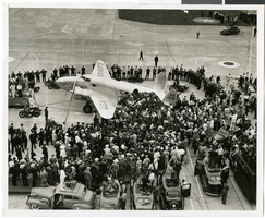
Photograph of crowds at Floyd Bennett Airfield, New York, July 14, 1938
Date
1938-07-14
Archival Collection
Description
The black and white view of Howard Hughes' Lockheed 14 aircraft after performing its final landing on the Round the World flight at Floyd Bennett Airport, New York. Description printed on photograph's accompanying sheet of paper: "Journey's end for world fliers! Floyd Bennett Airport, N.Y.--- The plane which carried Howard Hughes and four companions on their dramatic dash around the world, is shown shortly after it landed here at the conclusion of the flight. Crowds swarmed about the craft as the fliers hesitantly prepared to leave the ship. 7/14/1938."
Image

Photograph of a crowd awaiting the arrival of Howard Hughes, New York, July 14, 1938
Date
1938-07-14
Archival Collection
Description
The black and white view of a crowd of people awaiting the arrival of Howard Hughes in his Lockheed 14 aircraft at Floyd Bennett Airport, New York. This final landing for Hughes marked the end of his Round The World flight.
Image

Map of California, with territories of Utah, Nevada, Colorado, New Mexico, and Arizona, 1864
Date
1864
Description
40 x 62 cm. Relief shown by hachures. Prime meridians: Greenwich and Washington. Page numbers at top: 58-59. "Entered according to act of Congress in the year 1864 by A. J. Johnson in the Clerk's Office of the District Court of the United States for the Southern District of New York." Original publisher: Johnson and Ward.
Image
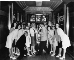
Photograph of Las Vegas High School Rhythmettes and Jack Dempsey, New York City, June 1964
Date
1964-06
Archival Collection
Description
The Las Vegas High School Rhythmettes pose with Jack Dempsey in his restaurant in New York City, New York.
Image
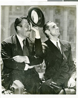
Photograph of Howard Hughes and Grover Whalen, New York City, July 15, 1938
Date
1938-07-15
Archival Collection
Description
The black and white view of Grover Whalen (left) and Howard Hughes (right) enjoying the attention from a crowd of thousands of people who attended a parade that celebrated Hughes' completion of his Round the World flight in New York City.
Image

Map of California, Utah, Nevada, Colorado, New Mexico and Arizona, 1864
Date
1864
Description
'Johnson's California, also Utah, Nevada, Colorado, New Mexico, and Arizona, published by A.J. Johnson, New York.' 'Entered according to Act of Congress in the Year 1864, by A.J. Johnson in the Clerks Office of the District Court of the United States for the Southern District of New York.' Atlas page numbers in upper margin: 66-67. Relief shown by hachures. Prime meridians: Greenwich and Washington, D.C. Shows proposed railroads, locations of Indian tribes, natural features, counties, mines, mail routes, trails and routes of exploring expeditions. On verso: History and statistics of Mexico and Central America and statistics of national finances and the Post Office of the United States, 1860. Scale [ca. 1:3,484,800. 1 in. to ca. 55 miles] (W 123°--W 103°/N 42°--N 32°)
Text
T-Shirt Color: Gray; Front: Detectives Association Inc. Nassau County, New York, Dept. Emblem; Handwritten Text: New York/Nassau Remembers, approximately 2001-2012
Level of Description
File
Archival Collection
New York-New York Hotel and Casino 9-11 Heroes Tribute Collection
To request this item in person:
Collection Number: MS-00459
Collection Name: New York-New York Hotel and Casino 9-11 Heroes Tribute Collection
Box/Folder: Box 29
Collection Name: New York-New York Hotel and Casino 9-11 Heroes Tribute Collection
Box/Folder: Box 29
Archival Component
127 New York (N.Y.), Culinary Union, 1990s (folder 1 of 1), image 1
Date
1990 to 1999
Description
Arrangement note: Series III. Internal: Work
Image
127 New York (N.Y.), Culinary Union, 1990s (folder 1 of 1), image 2
Date
1990 to 1999
Description
Arrangement note: Series III. Internal: Work
Image
127 New York (N.Y.), Culinary Union, 1990s (folder 1 of 1), image 3
Date
1990 to 1999
Description
Arrangement note: Series III. Internal: Work
Image