Search Results
#68163: New Landscaping along William D. Carlson Education and southwest corner, 2011 July 05
Level of Description
File
Archival Collection
University of Nevada, Las Vegas Creative Services Records (2010s)
To request this item in person:
Collection Number: PH-00388-05
Collection Name: University of Nevada, Las Vegas Creative Services Records (2010s)
Box/Folder: Digital File 00
Collection Name: University of Nevada, Las Vegas Creative Services Records (2010s)
Box/Folder: Digital File 00
Archival Component
The New St. Charles, H.M.M.B.A. 19th Annual Banquet, menu, 1898 April 15
Level of Description
File
Archival Collection
UNLV University Libraries Menu Collection
To request this item in person:
Collection Number: MS-00436
Collection Name: UNLV University Libraries Menu Collection
Box/Folder: Box 110
Collection Name: UNLV University Libraries Menu Collection
Box/Folder: Box 110
Archival Component
#70956: Adam Schroeder, music professor and baritone saxophonist., 2016 July 15
Level of Description
File
Archival Collection
University of Nevada, Las Vegas Creative Services Records (2010s)
To request this item in person:
Collection Number: PH-00388-05
Collection Name: University of Nevada, Las Vegas Creative Services Records (2010s)
Box/Folder: Digital File 00
Collection Name: University of Nevada, Las Vegas Creative Services Records (2010s)
Box/Folder: Digital File 00
Archival Component
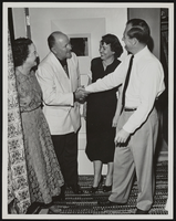
Photograph of individuals shaking hands, Las Vegas (Nev.), July 15, 1951
Date
1951-07-15
Archival Collection
Description
Four individuals stand together in a doorway while the men shake hands at a "party at the Moore home."
Image

Geologic map of the northeast quarter of the Bullfrog 15-minute quadrangle, Nye County, Nevada, 1990
Date
1990
Description
58 x 46 cm., on sheet 87 x 102 cm., folded in envelope 30 x 24 cm. Relief shown by contours and spot heights. "Contour interval 40 feet." "Base from U.S. Geological Survey 1:62,500. 1954." "Geology mapped in 1985 and 1988." Includes text, bibliography, 4 col. cross sections, and location and index maps. "Prepared in cooperation with the U. S. Atomic Commission." Original publisher: U. S. Geological Survey, Series: Miscellaneous investigations series, map I, Scale: 1:24 000.
Image
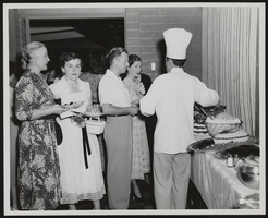
Photograph of a buffet at Moore party, Las Vegas (Nev.), July 15, 1951
Date
1951-07-15
Archival Collection
Description
Party guests stand in a buffet line at a "party at the Moore home" and are served by a uniformed chef. Street Address: 1201 South 6th Street
Image

Photograph of party guests in a corner, Las Vegas (Nev.), July 15, 1951
Date
1951-07-15
Archival Collection
Description
Two unidentified men and a woman stand together in a corner during a "party at the Moore home."
Image
Latin Quarter (New York): contract (typescript) between Donn Arden and E.M. Loew, 1957 July
Level of Description
File
Archival Collection
Donn Arden Papers
To request this item in person:
Collection Number: MS-00425
Collection Name: Donn Arden Papers
Box/Folder: Box 3
Collection Name: Donn Arden Papers
Box/Folder: Box 3
Archival Component
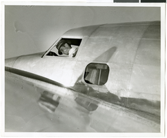
Photograph of Howard Hughes in his Lockheed 14 aircraft, Floyd Bennett Field, New York, July 10, 1938
Date
1938-07-10
Archival Collection
Description
The black and white view of Howard Hughes in his Lockheed 14 aircraft at Floyd Bennett Field in New York. Text printed on accompanying paper strip: "Hughes takes off on flight to Paris. Floyd Bennett Field, New York City-- Howard Hughes, multi-millionaire speed flyer, pictured in the nose of his Hughes Lockheed "Flying Laboratory" as Hughes and his picked crew of four prepared for the take-off to Paris and probably around the world on July 10th. A few minutes after this picture was taken, the giant ship lifted from the field to follow the trail blazed by Chrales A. Lindbergh. Credit Line (ACME) 7/10/38."
Image

Map showing U.S. Bureau of Reclamation Region 3 projects in Arizona, California, Nevada, New Mexico and Utah, September 1967
Date
1967-09
Description
'United States, Department of the Interior, Stewart L. Udall, Secretary. Bureau of Reclamation, Floyd E. Dominy, Commissioner.' 'Map. No. X-300-738. September 1967.' Scale [ca. 1:1,774,080] (W 119°--W 108°/N 39°--N 32°). Relief shown pictorially. Shows completed, under construction and proposed dams and reservoirs, canals, and aqueducts, power plants, pumping plants, substations, transmission lines, tunnels and siphons. Also shows non-Bureau of Reclamation dams, reservoirs, tunnels, pipelines and irrigated lands. Includes inset map of location of Region 3 and key map of drainage basins. Bureau of Reclamation, [Region 3?].
Image