Search Results
Miracles and Turner and coaster, 2001 July 11-15
Level of Description
File
Archival Collection
Stardust Resort and Casino Records
To request this item in person:
Collection Number: MS-00515
Collection Name: Stardust Resort and Casino Records
Box/Folder: Box 283
Collection Name: Stardust Resort and Casino Records
Box/Folder: Box 283
Archival Component
"Heifitz, Music. Violin music", 1975 July 15
Level of Description
File
Archival Collection
Maurine and Fred Wilson Papers
To request this item in person:
Collection Number: MS-00012
Collection Name: Maurine and Fred Wilson Papers
Box/Folder: Box 07
Collection Name: Maurine and Fred Wilson Papers
Box/Folder: Box 07
Archival Component
Photograph of Howard Hughes at Floyd Bennett Airfield, New York, July 14, 1938
Date
1938-07-14
Archival Collection
Description
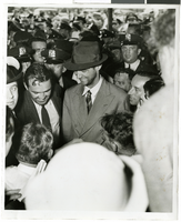
The up close view of Howard Hughes being escorted through a crowd of people at Floyd Bennett Airfield in New York. Description printed on photograph's accompanying sheet of paper: "Escorted through crowd- 7/14/38 (Daily News)"
Image
Photograph of Howard Hughes at Floyd Bennett Airfield, New York, July 14, 1938
Date
1938-07-14
Archival Collection
Description
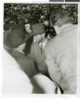
The up close view of Howard Hughes being escorted through a crowd of people at Floyd Bennett Airfield in New York. Description printed on photograph's accompanying sheet of paper: "Escorted through crowd- 7/14/38 (Daily News)"
Image
Photograph of Howard Hughes at Floyd Bennett Airfield, New York, July 14, 1938
Date
1938-07-14
Archival Collection
Description
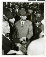
The up close view of Howard Hughes being escorted through a crowd of people at Floyd Bennett Airfield in New York. Description printed on photograph's accompanying sheet of paper: "Escorted through crowd- 7/14/38 (Daily News)"
Image
George Treem and Charlie Dorenwend, 1954 July 15
Level of Description
File
Archival Collection
Henderson Public Library Photograph Collection on Henderson, Nevada
To request this item in person:
Collection Number: PH-00254
Collection Name: Henderson Public Library Photograph Collection on Henderson, Nevada
Box/Folder: Folder 01
Collection Name: Henderson Public Library Photograph Collection on Henderson, Nevada
Box/Folder: Folder 01
Archival Component
New York-New York Hotel & Casino: first floor interior load requirements, 1995 July
Level of Description
File
Archival Collection
Donna Silva Lighting Design Plans
To request this item in person:
Collection Number: MS-01151
Collection Name: Donna Silva Lighting Design Plans
Box/Folder: Roll 13
Collection Name: Donna Silva Lighting Design Plans
Box/Folder: Roll 13
Archival Component
Carson, Steve, Stewart Title, 1975 July 15
Level of Description
File
Archival Collection
Frank Mitrani Photographs
To request this item in person:
Collection Number: PH-00332
Collection Name: Frank Mitrani Photographs
Box/Folder: Box 42
Collection Name: Frank Mitrani Photographs
Box/Folder: Box 42
Archival Component
#69250: Melissa Rorie, new faculty member on August 15, 2013, 2013 August 15
Level of Description
File
Archival Collection
University of Nevada, Las Vegas Creative Services Records (2010s)
To request this item in person:
Collection Number: PH-00388-05
Collection Name: University of Nevada, Las Vegas Creative Services Records (2010s)
Box/Folder: Digital File 00
Collection Name: University of Nevada, Las Vegas Creative Services Records (2010s)
Box/Folder: Digital File 00
Archival Component
Emriquez, Mary, Ronzones Apparel, 1968 July 15
Level of Description
File
Archival Collection
Frank Mitrani Photographs
To request this item in person:
Collection Number: PH-00332
Collection Name: Frank Mitrani Photographs
Box/Folder: Box 17
Collection Name: Frank Mitrani Photographs
Box/Folder: Box 17
Archival Component