Search Results
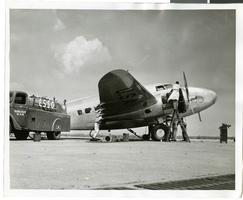
Photograph of mechanics with the Lockheed 14 aircraft, New York, July 10, 1938
Date
1938-07-10
Archival Collection
Description
The black and white view of a plane used by Howard Hughes being fueled up at Floyd Bennett Field in New York.
Image
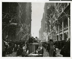
Photograph of a parade procession for Howard Hughes, New York, July 15, 1938
Date
1938-07-15
Archival Collection
Description
Typed onto a piece of paper attached to the image: "New York hails heroes of World Flight, New York City --- In the greatest reception since Lindbergh's, Howard Hughes and his gallant companions paraded up Broadway today, almost smothered beneath New York's ticker-tape accolade recognizing their record-smashing world dash. Here's Hughes, (center back, seat), gazing up the tons of torn paper fluttering down on him and his comrades, following in the car behind. Beside Hughes on the left is Grover Whalen, head of the New York World's Fair, 1939. Credit Line (ACME) 7/15/38."
Image
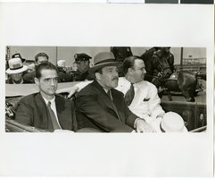
Photograph of Howard Hughes and crew at a parade, New York, July 15, 1938
Date
1938-07-15
Archival Collection
Description
The iew of Howard Hughes and his crew at a parade for Howard Hughes after he completed his Around The World flight in New York. Typed onto a piece of paper attached to the image: "Howard Hughes receiving the applause of the crowd during his reception in New York City. - 7-15-38. (Press Association.)"
Image
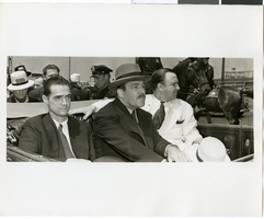
Photograph of Howard Hughes and crew at a parade, New York, July 15, 1938
Date
1938-07-15
Archival Collection
Description
The view of Howard Hughes and his crew at a parade for Howard Hughes after he completed his Around The World flight in New York. Typed onto a piece of paper attached to the image: "Howard Hughes receiving the applause of the crowd during his reception in New York City. - 7-15-38. (Press Association.)"
Image
The New Superstar Commune: Las Vegas, Cavalier, 1975 July 24
Level of Description
Item
Archival Collection
Arnold Shaw Papers
Archival Component
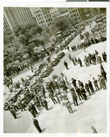
Photograph of a parade for Howard Hughes, New York City, July 15, 1938
Date
1938-07-15
Archival Collection
Description
Typed onto a piece of paper attached to the image: "New York welcoming Howard Hughes - General scene outside City Hall. 7/15/38."
Image

Photograph of a parade procession for Howard Hughes, New York, July 15, 1938
Date
1938-07-15
Archival Collection
Description
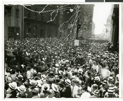
A picture of the crowd at a parade celebrating the completion of Howard Hughes' round the world flight.
Image
Photograph of a parade procession for Howard Hughes, New York, July 15, 1938
Date
1938-07-15
Archival Collection
Description
A general view of the parade consisting of thousands of people celebrating Howard Hughes' completion of his round-the-world flight.
Image
Howard Hughes at Floyd Bennett Airfield, New York, 1938 July
Level of Description
File
Archival Collection
Howard Hughes Public Relations Photograph Collection
Archival Component
#65212: New Student Union Building, Exteriors, 2006 July 05
Level of Description
File
Archival Collection
University of Nevada, Las Vegas Creative Services Records (2000s)
Archival Component