Search Results

Map of California, Nevada, Utah, Colorado, Arizona & New Mexico, circa 1867
Date
1865 to 1869
Description
39 x 62 cm. Relief shown by hachures and spot heights. Prime meridian: Greenwich and Washington. Hand colored. Shows natural features, populated places, routes of mail steamships, routes of explorers, locations of Indian tribes, railroad routes, and proposed railroad routes. In top margin: No. 80-81. On verso: New Mexico, Arizona, Colorado, Idaho, Dakota (statistics and other information) and The state of California (statistics and other information). Original publisher: G.W. and C.B. Colton.
Image

Map of California, and territories of Utah, Nevada, Colorado, New Mexico and Arizona, 1864
Date
1864
Description
'Johnson's California, also Utah, Nevada, Colorado, New Mexico, and Arizona, published by A.J. Johnson, New York.' 'Entered according to act of Congress in the year 1864, by A.J. Johnson in the Clerks Office of the District Court of the United States for the southern district of New York.' Atlas page numbers in upper margin: 67-68. Relief shown by hachures. Prime meridian: Greenwich and Washington. Shows natural features, locations of Indian tribes, proposed railroad routes, routes of explorers, trails, county boundaries and populated places. Hand colored. On verso: 'Historical and statistical view of the West India Islands or Columbian Archipelago' (p. 80) and 'Historical and statistical view of Mexico and Central America' (p. 79). Scale [ca. 1:3,484,800]. 1 in. to ca. 55 miles (W 124°--W 102°/N 42°--N 32°).
Text
George Francis Robert Bell, age one month on the baby scales, probably 1938 July
Level of Description
File
Archival Collection
Walking Box Ranch Photograph Collection
To request this item in person:
Collection Number: PH-00346
Collection Name: Walking Box Ranch Photograph Collection
Box/Folder: N/A
Collection Name: Walking Box Ranch Photograph Collection
Box/Folder: N/A
Archival Component
Letter from A. S. Halsted to W. H. Comstock, July 15, 1922
Date
1922-07-15
Archival Collection
Description
Halsted advises on legal interpretations of use of force in guarding railroad property.
Text
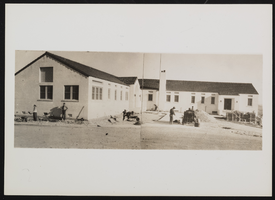
Photograph of recreation area administration building, Boulder city (Nev.), March 31, 1938
Date
1938-03-31
Archival Collection
Description
General view of workers standing outside of the administration building at Boulder Dam Recreation Area.
Image
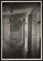
Photograph of museum basement underneath the stairs, Boulder City (Nev.), January 10, 1938
Date
1938-01-10
Archival Collection
Description
Center of the basement museum room, looking southwest, showing space underneath the stairs. This area was possibly used for diorama installation.
Image
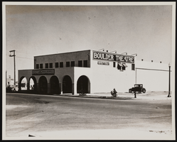
Photograph of a theater, Boulder City (Nev.), September 15, 1932
Date
1932-09-15
Archival Collection
Description
The photograph taken by B.D. Glaha September 15, 1932 of the Boulder Theater in Boulder City, Nevada. The marquee reads: American Madness with Walter Huston, Kay Johnson, also Igloo, a thrilling adventure of the Frozen Arctic.
Image
Restaurant in the Showboat Casino, Atlantic City, New Jersey, 1986
Level of Description
Item
Archival Collection
Showboat Atlantic City Photograph Collection
To request this item in person:
Collection Number: PH-00329
Collection Name: Showboat Atlantic City Photograph Collection
Box/Folder: Folder 01
Collection Name: Showboat Atlantic City Photograph Collection
Box/Folder: Folder 01
Archival Component
Gamblers in the Showboat Casino, Atlantic City, New Jersey, 1986
Level of Description
Item
Archival Collection
Showboat Atlantic City Photograph Collection
To request this item in person:
Collection Number: PH-00329
Collection Name: Showboat Atlantic City Photograph Collection
Box/Folder: Folder 01
Collection Name: Showboat Atlantic City Photograph Collection
Box/Folder: Folder 01
Archival Component

Map of California, Utah, Nevada, Colorado, New Mexico and Arizona, circa 1867
Date
1865 to 1869
Description
39 x 56 cm. Relief shown by hachures. "Entered according to act of Congress in the year 1864, by A.J. Johnson in the Clerks Office of the United States for the Southern District of New York." Atlas page numbers in upper margin: 67-68. Primer meridians: Greenwich and Washington, D.C. On verso: History and statistical view of the West India islands or Columbian Archipelago and Historical and statistical view of Mexico and Central America. Shows proposed railroads, locations of Indian tribes, natural features, counties, mines, mail routes, trails and routes of exploring expeditions. Has decorative border. Southern part of Nevada was added to the state in 1867 and is part of Nevada on this map, but Lincoln County was established in 1867 and is not on this map. This map was still probably published in 1867 in spite of someone's having written "1864" in pencil in the lower right corner of the Library's copy. Original publisher: A.J. Johnson.
Image