Search Results

Map of California, and territories of Utah, Nevada, Colorado, New Mexico and Arizona, 1864
Date
1864
Description
'Johnson's California, also Utah, Nevada, Colorado, New Mexico, and Arizona, published by A.J. Johnson, New York.' 'Entered according to act of Congress in the year 1864, by A.J. Johnson in the Clerks Office of the District Court of the United States for the southern district of New York.' Atlas page numbers in upper margin: 67-68. Relief shown by hachures. Prime meridian: Greenwich and Washington. Shows natural features, locations of Indian tribes, proposed railroad routes, routes of explorers, trails, county boundaries and populated places. Hand colored. On verso: 'Historical and statistical view of the West India Islands or Columbian Archipelago' (p. 80) and 'Historical and statistical view of Mexico and Central America' (p. 79). Scale [ca. 1:3,484,800]. 1 in. to ca. 55 miles (W 124°--W 102°/N 42°--N 32°).
Text
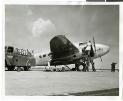
Photograph of mechanics with the Lockheed 14 aircraft, New York, July 10, 1938
Date
1938-07-10
Archival Collection
Description
The black and white view of a plane used by Howard Hughes being fueled up at Floyd Bennett Field in New York.
Image
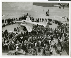
Photograph of crowds at Floyd Bennett Airfield, New York, July 14, 1938
Date
1938-07-14
Archival Collection
Description
The black and white view of Howard Hughes' Lockheed 14 aircraft after performing its final landing on the Round the World flight at Floyd Bennett Airport, New York. Description printed on photograph's accompanying sheet of paper: "Police circle Lockheed-14 at Floyd Bennett Airport."
Image
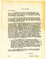
Letter from A. S. Halsted to W. H. Comstock, July 15, 1922
Date
1922-07-15
Archival Collection
Description
Halsted advises on legal interpretations of use of force in guarding railroad property.
Text
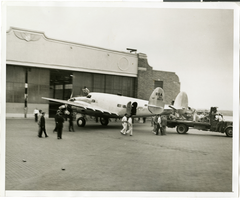
Photograph of the Lockheed 14 aircraft at Floyd Bennnett Airport, New York, July 9, 1938
Date
1938-07-09
Archival Collection
Description
The black and white view of the Lockheed 14 aircraft at the Floyd Bennett Airport in New York. Typed on a piece of paper attached to the image: "Readying Hughes' plane for Paris flight. New York City-- Mechanics hastened to put Howard Hughes' Lockheed 14 monoplane in shape for a flight from Floyd Bennett Airport here, to Paris. Motor trouble forced postponement and helpers were working under injunction to have the ship ready for a takeoff, July 9, "at the earliest possible moment." Photo shows: the plane being pulled out of the hangar by a truck. Credit Line (ACME) 7/9/38."
Image

Map of California, Utah, Nevada, Colorado, New Mexico and Arizona, circa 1867
Date
1865 to 1869
Description
39 x 56 cm. Relief shown by hachures. "Entered according to act of Congress in the year 1864, by A.J. Johnson in the Clerks Office of the United States for the Southern District of New York." Atlas page numbers in upper margin: 67-68. Primer meridians: Greenwich and Washington, D.C. On verso: History and statistical view of the West India islands or Columbian Archipelago and Historical and statistical view of Mexico and Central America. Shows proposed railroads, locations of Indian tribes, natural features, counties, mines, mail routes, trails and routes of exploring expeditions. Has decorative border. Southern part of Nevada was added to the state in 1867 and is part of Nevada on this map, but Lincoln County was established in 1867 and is not on this map. This map was still probably published in 1867 in spite of someone's having written "1864" in pencil in the lower right corner of the Library's copy. Original publisher: A.J. Johnson.
Image
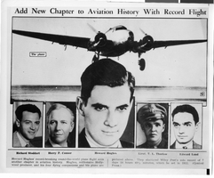
Photograph of Howard Hughes and crew, New York, July 1938
Date
1938-07
Archival Collection
Description
Photograph of a newspaper clipping featuring Howard Hughes and his crew. Typed onto a piece of paper attached to the image: "Crowd waits for glimpse of Howard Hughes as he leaves the home of Al. Lodwick and enters automobile. 7/38."
Image
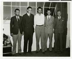
Photograph of Howard Hughes and other men, New York, July 14, 1938
Date
1938-07-14
Archival Collection
Description
Description printed on photograph's accompanying sheet of paper: "Group at [Gover] Whalen's home 7/14/38. (Daily News)." Howard Hughes is standing third from the left.
Image

Photograph of Howard Hughes and other men, New York, July 14, 1938
Date
1938-07-14
Archival Collection
Description
Description printed on photograph's accompanying sheet of paper: "Group at [Gover] Whalen's home 7/14/38. (Daily News)." Howard Hughes is standing third from the left.
Image
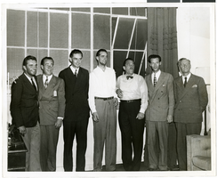
Photograph of Howard Hughes and other men, New York, July 14, 1938
Date
1938-07-14
Archival Collection
Description
Description printed on photograph's accompanying sheet of paper: "Group at [Gover] Whalen's home 7/14/38. (Daily News)." Howard Hughes is standing fourth from the left.
Image