Search Results
Del Webb's Sahara Boardwalk-Atlantic City, New Jersey
Level of Description
File
Archival Collection
Martin Stern Architectural Records
To request this item in person:
Collection Number: MS-00382
Collection Name: Martin Stern Architectural Records
Box/Folder: N/A
Collection Name: Martin Stern Architectural Records
Box/Folder: N/A
Archival Component
Harrah's Marina Hotel Casino: Atlantic City, New Jersey
Level of Description
Series
Archival Collection
Martin Stern Architectural Records
To request this item in person:
Collection Number: MS-00382
Collection Name: Martin Stern Architectural Records
Box/Folder: N/A
Collection Name: Martin Stern Architectural Records
Box/Folder: N/A
Archival Component
"The Meadowlands and New York City's Harness Racing Industry", 1987
Level of Description
File
Archival Collection
Eugene Martin Christiansen Papers
To request this item in person:
Collection Number: MS-00561
Collection Name: Eugene Martin Christiansen Papers
Box/Folder: Box 049
Collection Name: Eugene Martin Christiansen Papers
Box/Folder: Box 049
Archival Component
Coalition for Casino Gambling: plan for New York City, undated
Level of Description
File
Archival Collection
Eugene Martin Christiansen Papers
To request this item in person:
Collection Number: MS-00561
Collection Name: Eugene Martin Christiansen Papers
Box/Folder: Box 163
Collection Name: Eugene Martin Christiansen Papers
Box/Folder: Box 163
Archival Component
New York City Council news reports and correspondence, 1990
Level of Description
File
Archival Collection
Eugene Martin Christiansen Papers
To request this item in person:
Collection Number: MS-00561
Collection Name: Eugene Martin Christiansen Papers
Box/Folder: Box 163
Collection Name: Eugene Martin Christiansen Papers
Box/Folder: Box 163
Archival Component
"Yankee Baseball Greats 1938" photograph, 1938
Level of Description
File
Archival Collection
Nat Hart Professional Papers
To request this item in person:
Collection Number: MS-00419
Collection Name: Nat Hart Professional Papers
Box/Folder: Box 16 (Restrictions apply)
Collection Name: Nat Hart Professional Papers
Box/Folder: Box 16 (Restrictions apply)
Archival Component
New York City Pizza, menu, approximately 1961 to 1990
Level of Description
File
Archival Collection
UNLV University Libraries Menu Collection
To request this item in person:
Collection Number: MS-00436
Collection Name: UNLV University Libraries Menu Collection
Box/Folder: Box 35
Collection Name: UNLV University Libraries Menu Collection
Box/Folder: Box 35
Archival Component
T-Shirt Color: Gray; Front: City Of New York Fire Dept. FDNY, Dept. Badge W/ New York City Sky Line, approximately 2001-2012
Level of Description
File
Archival Collection
New York-New York Hotel and Casino 9-11 Heroes Tribute Collection
To request this item in person:
Collection Number: MS-00459
Collection Name: New York-New York Hotel and Casino 9-11 Heroes Tribute Collection
Box/Folder: Box 357
Collection Name: New York-New York Hotel and Casino 9-11 Heroes Tribute Collection
Box/Folder: Box 357
Archival Component
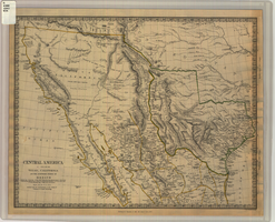
Map of Texas, California, New Mexico and the northern states of Mexico, October 15, 1842
Date
1842-10-15
Description
'Published under the superintendence of the Society for Diffusion of Useful Knowledge.' 'Published by Chapman & Hall, 186 Strand, 15 Oct. 1842.' 'J. & C. Walker, Sculpt.' Scale [ca. 1:7,600,000]. 1 in. to ca. 120 miles (W 125°--W 91°/N 43°--N 23° 30?). 1 map ; 31 x 39 cm. Relief indicated by hachures and spot heights. Shows elevations in yards. Includes notes on exploring expeditions, etc. Borders hand colored. Chapman & Hall.
Image
Colorado River Aqueduct News, 1934 January 15-1938 April 25
Level of Description
File
Archival Collection
Frank D. Rathbun Archaeology Papers
To request this item in person:
Collection Number: MS-00209
Collection Name: Frank D. Rathbun Archaeology Papers
Box/Folder: Box 01 (Restrictions apply)
Collection Name: Frank D. Rathbun Archaeology Papers
Box/Folder: Box 01 (Restrictions apply)
Archival Component