Search Results
Howard Hughes and his crew in Floyd Bennett Field, New York, 1938 July 10
Level of Description
File
Archival Collection
Howard Hughes Public Relations Photograph Collection
Archival Component
Howard Hughes and his crew in Floyd Bennett Field, New York, 1938 July 10
Level of Description
File
Archival Collection
Howard Hughes Public Relations Photograph Collection
Archival Component
Howard Hughes and his crew in Floyd Bennett Field, New York, 1938 July 10
Level of Description
File
Archival Collection
Howard Hughes Public Relations Photograph Collection
Archival Component
Howard Hughes and his crew in Floyd Bennett Field, New York, 1938 July 10
Level of Description
File
Archival Collection
Howard Hughes Public Relations Photograph Collection
Archival Component
Howard Hughes and his crew in Floyd Bennett Field, New York, 1938 July 10
Level of Description
File
Archival Collection
Howard Hughes Public Relations Photograph Collection
Archival Component
Howard Hughes and Grover Whalen at Floyd Bennett Field, New York, 1938 July 10
Level of Description
File
Archival Collection
Howard Hughes Public Relations Photograph Collection
Archival Component
Howard Hughes and Grover Whalen at Floyd Bennett Field, New York, 1938 July 10
Level of Description
File
Archival Collection
Howard Hughes Public Relations Photograph Collection
Archival Component
#69247: New faculty members on August 15, 2013, 2013 August 15
Level of Description
File
Archival Collection
University of Nevada, Las Vegas Creative Services Records (2010s)
Archival Component

Map of California, Utah, Nevada, Colorado, New Mexico and Arizona, 1864
Date
1864
Description
'Johnson's California, also Utah, Nevada, Colorado, New Mexico, and Arizona, published by A.J. Johnson, New York.' 'Entered according to Act of Congress in the Year 1864, by A.J. Johnson in the Clerks Office of the District Court of the United States for the Southern District of New York.' Atlas page numbers in upper margin: 66-67. Relief shown by hachures. Prime meridians: Greenwich and Washington, D.C. Shows proposed railroads, locations of Indian tribes, natural features, counties, mines, mail routes, trails and routes of exploring expeditions. On verso: History and statistics of Mexico and Central America and statistics of national finances and the Post Office of the United States, 1860. Scale [ca. 1:3,484,800. 1 in. to ca. 55 miles] (W 123°--W 103°/N 42°--N 32°)
Text
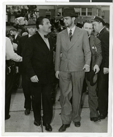
Photograph of Howard Hughes and Grover Whalen at Floyd Bennett Airfield, New York, July 14, 1938
Date
1938-07-14
Archival Collection
Description
A view of Howard Hughes and Grover Whalen at Floyd Bennett Airfield in New York. Description printed on photograph's accompanying sheet of paper: "Grover Whalen greets Hughes. New York City-- His face covered by stubble and still wearing his battered hat, Howard Hughes is taken in tow by Grover Whalen, World's Fair head, shortly after Hughes and his companions set their plane down at Floyd Bennett Airport here, completing their dramatic dash around the world. Credit Line (ACME) 7/14/38"
Image