Search the Special Collections and Archives Portal
Search Results
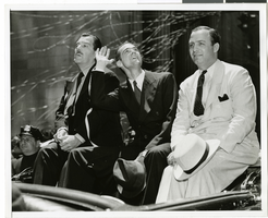
Photograph of a parade procession for Howard Hughes, New York, July 15, 1938
Date
1938-07-15
Archival Collection
Description
Description printed on photograph's accompanying sheet of paper: "Hughes waves to cheering million. New York City--- Clean-shaven once more, Howard Hughes smiles his gratitude to the millions of New Yorkers who showered him with ticker-tape and torn paper--New York's own accolade, as paraded up Broadway, followed by his companions in the carbehind in the greatest reception since Lindbergh's. On the left is Grover Whalen, head of the New York World's Fair, 1939, and on the right, Al Lodwick, manager of the round-the-world record smashing flight. Credit Line (ACME) 7/15/38."
Image

Photograph of Howard Hughes in cockpit, New York, February 15, 1946
Date
1946-02-15
Archival Collection
Description
A view of Howard Hughes, left, and other men who helped to pilot a Trans World Airline aircraft in New York.
Image
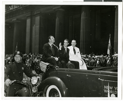
Photograph of a parade procession for Howard Hughes, New York, July 15, 1938
Date
1938-07-15
Archival Collection
Description
A view of Grover Whalen, Howard Hughes, and Al Lodwick riding in the back of an automobile during a parade procession. Description printed on back of photograph: "Howard Hughes welcomed at City Hall, New York. General scene. 7/15/38."
Image
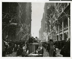
Photograph of a parade procession for Howard Hughes, New York, July 15, 1938
Date
1938-07-15
Archival Collection
Description
Typed onto a piece of paper attached to the image: "New York hails heroes of World Flight, New York City --- In the greatest reception since Lindbergh's, Howard Hughes and his gallant companions paraded up Broadway today, almost smothered beneath New York's ticker-tape accolade recognizing their record-smashing world dash. Here's Hughes, (center back, seat), gazing up the tons of torn paper fluttering down on him and his comrades, following in the car behind. Beside Hughes on the left is Grover Whalen, head of the New York World's Fair, 1939. Credit Line (ACME) 7/15/38."
Image
Adamar of New Jersey License Application, December 15, 1981
Level of Description
File
Archival Collection
International Association of Gaming Attorneys Collection
Pagination
- Previous page ‹‹
- Page 4
Archival Component
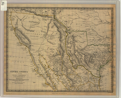
Map of Texas, California, New Mexico and the northern states of Mexico, October 15, 1842
Date
1842-10-15
Description
'Published under the superintendence of the Society for Diffusion of Useful Knowledge.' 'Published by Chapman & Hall, 186 Strand, 15 Oct. 1842.' 'J. & C. Walker, Sculpt.' Scale [ca. 1:7,600,000]. 1 in. to ca. 120 miles (W 125°--W 91°/N 43°--N 23° 30?). 1 map ; 31 x 39 cm. Relief indicated by hachures and spot heights. Shows elevations in yards. Includes notes on exploring expeditions, etc. Borders hand colored. Chapman & Hall.
Image
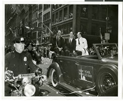
Photograph of Howard Hughes and his crew at a parade, New York, July 15, 1938
Date
1938-07-15
Archival Collection
Description
Description printed on back of photograph: "New York welcomes Howard Hughes. Grover Whalen also in car. 7/15/38."
Image
#69250: Melissa Rorie, new faculty member on August 15, 2013, 2013 August 15
Level of Description
File
Archival Collection
University of Nevada, Las Vegas Creative Services Records (2010s)
Pagination
- Previous page ‹‹
- Page 4
Archival Component

Photograph of Howard Hughes and crew at a parade, New York, July 15, 1938
Date
1938-07-15
Archival Collection
Description
Description printed on photograph's accompanying sheet of paper: "Members of the Howard Hughes flight around the world are (L-to-R) Thomas Thurlow, navigator; Richard Stoddart, radio engineer; Ed Lund, mechanic and H. P. Connor, co-navigator, as they rode in the welcoming parade in New York City 7-15-38."
Image
New faculty members on August 15, 2013: digital photographs
Date
2013-08-15
Archival Collection
Description
Photographs from the University of Nevada, Las Vegas Creative Services Records (2010s) (PH-00388-05). Client: Kristene Fisher, Vice Provost for Academic Affairs
Image
Pagination
Refine my results
Content Type
Creator or Contributor
Subject
Archival Collection
Digital Project
Resource Type
Year
Material Type
Place
Language
Records Classification
