Search Results
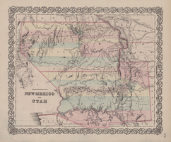
Map of territories of New Mexico and Utah, 1855
Date
1855
Description
29 x 36 cm. Shows natural features, and populated places, wagon route, proposed railroad routes and explorers' routes. Relief shown by hachures. Prime meridians: Greenwich and Washington. "Entered according to act of Congress in the year 1855 by J.H. Colton & Co in the Clerk's Office of the District Court of the U.S. for the Southern District of New York." Hand colored. Atlas p. number in lower-right margin: 51. Decorative border. The geographic region of Southwest is referred to as the New Southwest. Original publisher: J.H. Colton .
Image
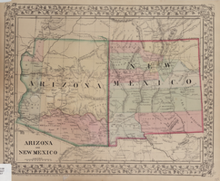
Map of Arizona and New Mexico, 1867
Date
1867
Description
26 x 32 cm. Relief shown by hachures. "Entered according to act of Congress in the year 1867 by S. Augustus Mitchell in the Clerks Office of the District Court for the Eastern District of Pennsylvania." Includes decorative border of grape vines. Shows Tucson as capital of Arizona; shows various trails including Cook's Wagon Route, Marcy's Route, and Kearney's Route. Written in pencil in lower right corner: 135. Original publisher: S.A. Mitchell.
Image
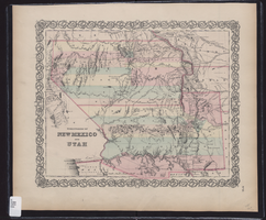
Map showing the territories of New Mexico and Utah, 1855
Date
1855
Description
'Entered according to Act of Congress in the year 1855 by J.H. Colton & Co. in the Clerk's Office of the Dist. Court of the U.S. for the South'n. Dist. of New York.' Scale [ca. 1:4,752,000. 1 in. to approx. 75 miles] (W 120°--W 102°/N 43°--N 32°). Shows natural features, and populated places, wagon route, proposed railroad routes and explorers' routes. Relief shown by hachures. Prime meridians: Greenwich and Washington.Hand colored. Atlas p. number in lower-right margin: 51. Decorative border. J.H. Colton & Co.
Image

Map of California and territories of New Mexico and Utah, circa 1861
Date
1856 to 1866
Description
40 x 60 cm. Relief shown by hachures and spot heights. Prime meridians: Greenwich and Washington. Atlas plate numbers 54 and 55 in the upper corners. Shows forts, trails, exploration routes, drainage, mail steamship routes, physical features, Indian tribes, and historic sites. The geographic region of Southwest is referred to as the New Southwest. Original publisher: Johnson .
Image

Map of California and territories of New Mexico and Utah, circa 1861
Date
1859 to 1862
Description
'Compiled, drawn, and engraved under the supervision of J.H. Colton and A.J. Johnson.' Relief shown by hachures and spot heights. Scale [ca. 1:3,041,280]. 1 in. to approx. 48 miles (W 124°--W 103°/N 42°--N 31°). Hand colored
Prime meridians: Greenwich and Washington
Plates 54 & 55 removed from Johnson's New illustrated family atlas of the world, with descriptions geographical, statistical and historical ... New York, 1862
Title page of atlas.
Prime meridians: Greenwich and Washington
Plates 54 & 55 removed from Johnson's New illustrated family atlas of the world, with descriptions geographical, statistical and historical ... New York, 1862
Title page of atlas.
Image

Map of California and Territories of New Mexico and Utah, 1862
Date
1862
Description
Scale [ca. 1:3,231,360. 1 in. to approx. 51 miles] (W 125°00--W 103°30/N 42°00--N 31°45) ; 1 map : hand col. ; 40 x 60 cm., on sheet 46 x 68 cm ; Relief indicated by hachures and spot heights ; Prime meridians: Greenwich and Washington, D.C ; Decorative border ; Hand colored ; Atlas p. numbers in upper margin: 58-59 ; Date est. from territorial borders and county configuration ; Shows natural features, locations of Indian tribes, proposed railroad routes, routes of explorers, trails, county boundaries and populated places ; Johnson and Ward
Image

Map of California, with territories of Utah, Nevada, Colorado, New Mexico, and Arizona, 1864
Date
1864
Description
40 x 62 cm. Relief shown by hachures. Prime meridians: Greenwich and Washington. Page numbers at top: 58-59. "Entered according to act of Congress in the year 1864 by A. J. Johnson in the Clerk's Office of the District Court of the United States for the Southern District of New York." Original publisher: Johnson and Ward.
Image

Map of California, Utah, Nevada, Colorado, New Mexico and Arizona, 1864
Date
1864
Description
'Johnson's California, with Utah, Nevada, Colorado, New Mexico, and Arizona, published by Johnson and Ward.' 'Entered according to Act of Congress in the Year 1864 by A.J. Johnson in the Clerks Office of the District Court of the United States for the southern district of New York.' Atlas page numbers in upper margin: 66-67. This is probably plate 67 from Johnson's New Illustrated Family Atlas, published in New York by Johnson & Ward in 1864. Shows natural features, locations of Indian tribes, proposed railroad routes, routes of explorers, trails, county boundaries and populated places ; "." ; Relief shown by hachures ; Prime meridians: Greenwich and Washington ; In top margin: 66-67 ; Hand colored ; On verso: Historical and statistical view of Mexico and central America (p. 79) and Historical and statistical view of the United States, 1860 (p. 78) Scale [ca. 1:3,484,800]. 1 in. to ca. 55 miles (W 124°--W 102°/N 42°--N 32°)
Text

Map of the territories of New Mexico, Arizona, Colorado, Nevada, and Utah, 1855
Date
1855
Description
29 x 36 cm. Relief shown by hachures. Prime meridians: Greenwich and Washington. "Entered according to act of Congress in the year 1855 by J.H. Colton & Co. in the Clerk's Office of the Dist. Office of the U.S. for the Southern. Dist. of New York." Hand colored. Decorative border. Atlas p. number in lower-right margin: 67. Shows routes of explorers, proposed railroad routes, wagon route, mail route, Indian reserves and mines. On verso: History and statistical view of Mexico. Original publisher: J.H. Colton.
Image
The New Fay Easter dinner menu, Sunday, April 7, 1912
Date
1912-04-07
Archival Collection
Description
Restaurant: The New Fay (Virginia, Minn.) Location: Virginia, Minnesota, United States
Text