Search Results
Sales material for the Granada model home in the El Encanto development, Las Vegas, Nevada, 1967-1969
Date
Archival Collection
Description
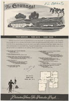
Sales material from the late 1960s for model no. 15 A residential home, called "The Granada," in the El Encanto development, Las Vegas, Nevada. One side has an illustration of the front exterior elevation, a floor plan, and a list of features. The other side shows two alternate exterior elevation illustrations (15A-3-L and 15A-1-R). The price is handwritten. The development is located between Harmon and Tropicana Avenues (north and south) and Sandhill Rd. (west) and S. Lamb Blvd. (east).
Site Name: El Encanto (Las Vegas, Nevada)
Text
Sales material for the Valencia model home in the El Encanto development, Las Vegas, Nevada, 1967-1969
Date
Archival Collection
Description
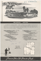
Sales material from the late 1960s for model no. 15 B residential home, called "The Valencia," in the El Encanto development, Las Vegas, Nevada. One side has an illustration of the front exterior elevation, a floor plan, and a list of features. The other side shows two alternate exterior elevation illustrations (15B-3-R and 15B-2-R). The price is handwritten. The development is located between Harmon and Tropicana Avenues (north and south) and Sandhill Rd. (west) and S. Lamb Blvd. (east).
Site Name: El Encanto (Las Vegas, Nevada)
Text
Sales material for the Conquistador model home in the El Encanto development, Las Vegas, Nevada, 1967-1969
Date
Archival Collection
Description
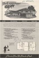
Sales material from the late 1960s for model no. 15 C residential home called "The Conquistador," in the El Encanto development, Las Vegas, Nevada. One side has an illustration of the front exterior elevation, a floor plan, and a list of features. The other side shows two alternate exterior elevation illustrations (15C-1-L and 15C-2-R). The price is handwritten. The development is located between Harmon and Tropicana Avenues (north and south) and Sandhill Rd. (west) and S. Lamb Blvd. (east).
Site Name: El Encanto (Las Vegas, Nevada)
Text
Pasadena, California - City of Pasadena (Municipal Light and Power Dept.), 1938-1944
Level of Description
Archival Collection
Collection Name: Union Pacific Railroad Collection
Box/Folder: Box 28
Archival Component
#72081: Marcus Civin is the new chair of art department and whose first day is July 15, 2018 April 26
Level of Description
Archival Collection
Collection Name: University of Nevada, Las Vegas Creative Services Records (2010s)
Box/Folder: Digital File 01
Archival Component

Postcard of the Museum of Memories, Virginia City (Nev.), January 3, 1938
Date
Description
Image
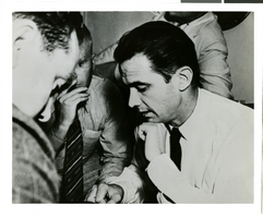
Photograph of Howard Hughes talking to newspapermen, Los Angeles, August 1, 1938
Date
Archival Collection
Description
Image
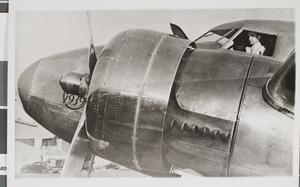
Photograph of Howard Hughes in a plane, Glendale, California, August 20, 1938
Date
Archival Collection
Description
Image
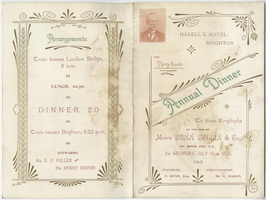
Dunn, Collin & Co. thirty-fourth annual dinner to their employees, menu, Saturday, July 15, 1899, at Haxell's Hotel
Date
Archival Collection
Description
Text
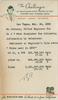
Memo about water usage in 1935 in Las Vegas, March 24, 1938
Date
Archival Collection
Description
Paper from notepad listing the number of gallons of water used in 1935 by the water company and the railroad. Information is provided by Johnson, Office Engineer. Typed telephone message from Mr. Johnson, Office Engineer.
Text