Search Results
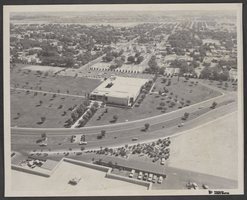
Aerial photograph of Civic Center Drive and North Las Vegas City Hall, May 23, 1970
Date
1905-05-23
Archival Collection
Description
An aerial view of the North Las Vegas City Hall and Civic Center Drive.
Image
Harrah's Grand, Atlantic City, New Jersey, 2001
Level of Description
File
Archival Collection
Robert Beckmann Photographs
To request this item in person:
Collection Number: PH-00381
Collection Name: Robert Beckmann Photographs
Box/Folder: Box 02
Collection Name: Robert Beckmann Photographs
Box/Folder: Box 02
Archival Component

City map of Las Vegas, 1973
Date
1905-05-26
Description
Color; 55 x 45 cm., on sheet 95 x 47 cm., folded to 24 x 10 cm. Panel title: Las Vegas city map. Copyright held by Cardinal Publishing Company. Relief shown by hachures. Includes illustrations and advertisements. Index, text, illustrations, advertisements, and map of "Lake Mead National Recreation Area, lower basin section" on verso. Original publisher: Cardinal Publishing Company.
Image
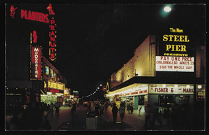
Nighttime view of Atlantic City, New Jersey: postcard
Date
1940 (year approximate) to 1990 (year approximate)
Archival Collection
Description
From Harvey's Hotel and Casino Postcard Collection (PH-00367)
Image
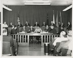
Photograph of a contract signing at City Hall, Las Vegas (Nev.), August 25, 1967
Date
1967-08-25
Archival Collection
Description
Signing of contracts for Lake Mead water pipeline at the Las Vegas City Hall. Sitting in the top row from left to right: unidentified individual, Arleigh West, Bureu of Reclamation, Oran Gragson, Mayor of Las Vegas, Paul Laxalt, Governor of Nevada, Robert Griffith, Chairman Colorado River Commission, William Taylor, Mayor of North Las Vegas, Leonard Fayle, President of Las Vegas Valley Water District, Mr. Hampton, Mayor of Henderson, Robert Broadbent, Mayor of Boulder City. Site Name: Clark County Court House, Las Vegas (Nev.)
Image

Map of California and Territories of New Mexico and Utah, 1862
Date
1862
Description
Scale [ca. 1:3,231,360. 1 in. to approx. 51 miles] (W 125°00--W 103°30/N 42°00--N 31°45) ; 1 map : hand col. ; 40 x 60 cm., on sheet 46 x 68 cm ; Relief indicated by hachures and spot heights ; Prime meridians: Greenwich and Washington, D.C ; Decorative border ; Hand colored ; Atlas p. numbers in upper margin: 58-59 ; Date est. from territorial borders and county configuration ; Shows natural features, locations of Indian tribes, proposed railroad routes, routes of explorers, trails, county boundaries and populated places ; Johnson and Ward
Image
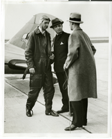
Photograph of Howard Hughes, Albert Lodwick, and unidentified man at Floyd Bennett Field, New York, April 21, 1936
Date
1936-04-21
Archival Collection
Description
Howard Hughes, Albert Lodwick, and an unidentified man at Floyd Bennett Field after record flight from Miami to New York.
Image
Latin Quarter (New York): contract (typescript) between Donn Arden and E.M. Loew
Date
1957-07
Archival Collection
Description
Series 2: Nightclubs
Text
The German Society of New York, 150th Anniversary Banquet, menu, 1934 November 22
Level of Description
File
Archival Collection
UNLV University Libraries Menu Collection
To request this item in person:
Collection Number: MS-00436
Collection Name: UNLV University Libraries Menu Collection
Box/Folder: Box 118
Collection Name: UNLV University Libraries Menu Collection
Box/Folder: Box 118
Archival Component
Willig, John. Off-track betting, from the horse's mouth: voting by New Yorkers, New York Times, 1963 November 03
Level of Description
File
Archival Collection
UNLV Libraries Collection of Articles on Gaming and Las Vegas, Nevada Topics
To request this item in person:
Collection Number: MS-00626
Collection Name: UNLV Libraries Collection of Articles on Gaming and Las Vegas, Nevada Topics
Box/Folder: Box 10
Collection Name: UNLV Libraries Collection of Articles on Gaming and Las Vegas, Nevada Topics
Box/Folder: Box 10
Archival Component