Search Results
George Francis Robert Bell, age one month on the baby scales, probably 1938 July
Level of Description
File
Archival Collection
Walking Box Ranch Photograph Collection
To request this item in person:
Collection Number: PH-00346
Collection Name: Walking Box Ranch Photograph Collection
Box/Folder: N/A
Collection Name: Walking Box Ranch Photograph Collection
Box/Folder: N/A
Archival Component

Map of California, Nevada, Utah, Colorado, Arizona & New Mexico, circa 1867
Date
1865 to 1869
Description
39 x 62 cm. Relief shown by hachures and spot heights. Prime meridian: Greenwich and Washington. Hand colored. Shows natural features, populated places, routes of mail steamships, routes of explorers, locations of Indian tribes, railroad routes, and proposed railroad routes. In top margin: No. 80-81. On verso: New Mexico, Arizona, Colorado, Idaho, Dakota (statistics and other information) and The state of California (statistics and other information). Original publisher: G.W. and C.B. Colton.
Image

Map of California, and territories of Utah, Nevada, Colorado, New Mexico and Arizona, 1864
Date
1864
Description
'Johnson's California, also Utah, Nevada, Colorado, New Mexico, and Arizona, published by A.J. Johnson, New York.' 'Entered according to act of Congress in the year 1864, by A.J. Johnson in the Clerks Office of the District Court of the United States for the southern district of New York.' Atlas page numbers in upper margin: 67-68. Relief shown by hachures. Prime meridian: Greenwich and Washington. Shows natural features, locations of Indian tribes, proposed railroad routes, routes of explorers, trails, county boundaries and populated places. Hand colored. On verso: 'Historical and statistical view of the West India Islands or Columbian Archipelago' (p. 80) and 'Historical and statistical view of Mexico and Central America' (p. 79). Scale [ca. 1:3,484,800]. 1 in. to ca. 55 miles (W 124°--W 102°/N 42°--N 32°).
Text
#67675: UNLV-TV Studios Inside Greenspun Hall, 2010 July 28
Level of Description
File
Archival Collection
University of Nevada, Las Vegas Creative Services Records (2010s)
To request this item in person:
Collection Number: PH-00388-05
Collection Name: University of Nevada, Las Vegas Creative Services Records (2010s)
Box/Folder: Digital File 00
Collection Name: University of Nevada, Las Vegas Creative Services Records (2010s)
Box/Folder: Digital File 00
Archival Component

Map of California, Utah, Nevada, Colorado, New Mexico and Arizona, circa 1867
Date
1865 to 1869
Description
39 x 56 cm. Relief shown by hachures. "Entered according to act of Congress in the year 1864, by A.J. Johnson in the Clerks Office of the United States for the Southern District of New York." Atlas page numbers in upper margin: 67-68. Primer meridians: Greenwich and Washington, D.C. On verso: History and statistical view of the West India islands or Columbian Archipelago and Historical and statistical view of Mexico and Central America. Shows proposed railroads, locations of Indian tribes, natural features, counties, mines, mail routes, trails and routes of exploring expeditions. Has decorative border. Southern part of Nevada was added to the state in 1867 and is part of Nevada on this map, but Lincoln County was established in 1867 and is not on this map. This map was still probably published in 1867 in spite of someone's having written "1864" in pencil in the lower right corner of the Library's copy. Original publisher: A.J. Johnson.
Image
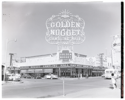
Film transparency of the Golden Nugget Gambling Hall, Las Vegas, Nevada, July, 1949
Date
1949-05
Archival Collection
Description
A view of the front of the Golden Nugget Gambling Hall. A banner advertising "Cooled by refrigeration always pleasant" is visible on the right-hand side of the building. The Nugget Saloon and a Shell gas station sign is visible in the background. The Golden Nugget opened in 1946, and is the first structure designed from the ground up to be a casino. Steve Wynn became the majority shareholder in 1973, and built the first tower in 1977. In 1984, the neon was removed from the building and the spa tower was built, along with the showroom. The third tower was opened in 1989. The hotel now has 2,419 rooms and suites. The casino's large hotel sign at its entrance off Fremont and Casino Center was removed in 1984 when the casino underwent renovations. The old sign presently sits at the YESCO (Young Electric Sign Company) sign yard.
Image
"Yankee Baseball Greats 1938" photograph, 1938
Level of Description
File
Archival Collection
Nat Hart Professional Papers
To request this item in person:
Collection Number: MS-00419
Collection Name: Nat Hart Professional Papers
Box/Folder: Box 16 (Restrictions apply)
Collection Name: Nat Hart Professional Papers
Box/Folder: Box 16 (Restrictions apply)
Archival Component
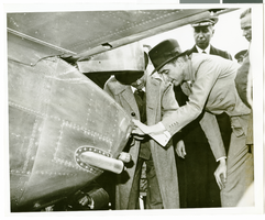
Photograph of Howard Hughes behind his plane at Le Bourget Airfield, France, July 1938
Date
1938-07
Archival Collection
Description
Description printed on accompanying strip of paper: "Howard Hughes inspects his machine on arrival at Le Bourget, France, on his round-the-world flight."
Image

Photograph of Howard Hughes and others at Hughes Tool Company, Houston, Texas, July 30, 1938
Date
1938-07-30
Archival Collection
Description
Howard Hughes, N.E. Boehm, and an unidentified man examining machinery in the Hughes Tool Company plant.
Image

Photograph of Howard Hughes and men at Hughes Tool Company, Houston, Texas, July 30, 1938
Date
1938-07-30
Archival Collection
Description
Howard Hughes (2nd from right) with group of men inside the Hughes Tool Company shop in Houston.
Image