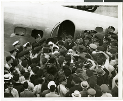
Search Results
Photograph of crowds at Floyd Bennett Airfield, New York, July 1938
Date
1938-07-14
Archival Collection
Description
The black and white view of Howard Hughes and his crew after completing the Around the World flight at Floyd Bennett Airport, New York. Description printed on photograph's accompanying sheet of paper: "A scene at Floyd Bennett Field as Howard Hughes and his crew landed after completing a round the world flight. 7-14-38 (Press Association)"
Image
Weaver, Randy, New York Life, 1986 July 08
Level of Description
File
Archival Collection
Frank Mitrani Photographs
Archival Component

Map of California, Nevada, Utah, Colorado, Arizona & New Mexico, circa 1867
Date
1865 to 1869
Description
39 x 62 cm. Relief shown by hachures and spot heights. Prime meridian: Greenwich and Washington. Hand colored. Shows natural features, populated places, routes of mail steamships, routes of explorers, locations of Indian tribes, railroad routes, and proposed railroad routes. In top margin: No. 80-81. On verso: New Mexico, Arizona, Colorado, Idaho, Dakota (statistics and other information) and The state of California (statistics and other information). Original publisher: G.W. and C.B. Colton.
Image
Photograph of crowds at Floyd Bennett Airfield, New York, July 1938
Date
1938-07-14
Archival Collection
Description
The black and white view of Howard Hughes' Lockheed 14 aircraft after performing its final landing on the Round the World flight at Floyd Bennett Airport, New York. Description printed on back of photograph: "Howard Hughes leaving his plane after flight around the world in three days, 19 hours and 17 minutes 7/14/38"
Image

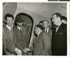
Photograph of crowds at Floyd Bennett Airfield, New York, July 1938
Date
1938-07-14
Archival Collection
Description
The black and white view of Howard Hughes exiting his Lockheed 14 aircraft after performing the final landing on the Round the World flight at Floyd Bennett Airport, New York. Description printed on photograph's accompanying sheet of paper: "World fliers greeted on arrival. Floyd Bennett Airport--- Minutes after he and his companions set their plane down here, completing a dramatic dash around the world, Howard Hughes, wearing the same battered hat, his face covered by a heavy stubble, stepped from the plane, to be greeted by Mayor La Guardia, in the photo are, left to right: Ed Lund, flight mechanic, Howard Hughes, Thomas Thurlow, navigator; Harry P. M. Connor, navigator, and Mayor La Guardia. Credit Line (ACME) 7/14/38"
Image
Audience reception to screening at WKO Proctor's Theater in New Rochelle, New York, 1951 July 17
Level of Description
File
Archival Collection
Howard Hughes Film Production Records
Archival Component

Map of California, and territories of Utah, Nevada, Colorado, New Mexico and Arizona, 1864
Date
1864
Description
'Johnson's California, also Utah, Nevada, Colorado, New Mexico, and Arizona, published by A.J. Johnson, New York.' 'Entered according to act of Congress in the year 1864, by A.J. Johnson in the Clerks Office of the District Court of the United States for the southern district of New York.' Atlas page numbers in upper margin: 67-68. Relief shown by hachures. Prime meridian: Greenwich and Washington. Shows natural features, locations of Indian tribes, proposed railroad routes, routes of explorers, trails, county boundaries and populated places. Hand colored. On verso: 'Historical and statistical view of the West India Islands or Columbian Archipelago' (p. 80) and 'Historical and statistical view of Mexico and Central America' (p. 79). Scale [ca. 1:3,484,800]. 1 in. to ca. 55 miles (W 124°--W 102°/N 42°--N 32°).
Text
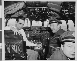
Photograph of Howard Hughes in cockpit, New York, February 15, 1946
Date
1946-02-15
Archival Collection
Description
Description given with photo: "After Non-Stop Coast to Coast Flight -- Pilot Howard Hughes (left) millionaire flier and movie producer, co-pilot Joseph Bartles, and navigator Robert Stevens, relax at the controls of their Lock-heed Constellation after landing at LaGuardia Field in new York City, Feb. 15 on Pre-Inaugural non-stop coast to coast flight from Burbank, Calif. the Constellation, named "Start of California" and carrying 34 passengers, including movie stars and a crew of seven, landed at LaGuardia Field eight hours and 38 minutes after leaving Burbank. 22/15/46."
Image
Holiday Inn Hotel and Casino, Marina Associates:, 1979 November 15; 1980 July 15
Level of Description
Series
Archival Collection
Martin Stern Architectural Records
Archival Component
Independence Day address, Las Vegas Convention Hall, 1976 July 04
Level of Description
File
Archival Collection
Howard Cannon Papers
Archival Component