Search Results
Photograph of Howard Hughes at Floyd Bennett Airfield, New York, July 14, 1938
Date
1938-07-14
Archival Collection
Description
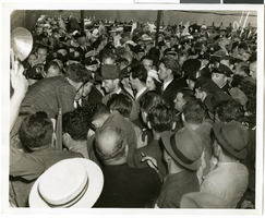
The black and white view of Howard Hughes, surrounded by crowds, after arriving completing his Around the World tour at Floyd Bennett Airfield in New York.
Image
Photograph of Howard Hughes at Floyd Bennett Airfield, New York, July 14, 1938
Date
1938-07-14
Archival Collection
Description
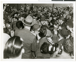
The black and white view of Howard Hughes, surrounded by crowds, after arriving completing his Around the World tour at Floyd Bennett Airfield in New York.
Image
Photograph of Howard Hughes at Floyd Bennett Airfield, New York, July 14, 1938
Date
1938-07-14
Archival Collection
Description
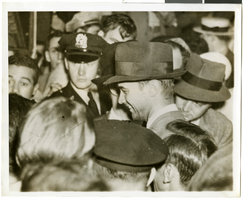
The black and white view of Howard Hughes, surrounded by crowds, after landing his Lockheed 14 aircraft for the Around the World flight at Floyd Bennett Airfield in New York. Description printed on photograph's accompanying sheet of paper: "Howard Hughes at Floyd Bennett Field after completing a round the world flight. 7-14-38 (Press Association)."
Image
#66818: Images for College of Business Banners Inside Beam Hall, 2009 January 15
Level of Description
File
Archival Collection
University of Nevada, Las Vegas Creative Services Records (2000s)
To request this item in person:
Collection Number: PH-00388-04
Collection Name: University of Nevada, Las Vegas Creative Services Records (2000s)
Box/Folder: N/A
Collection Name: University of Nevada, Las Vegas Creative Services Records (2000s)
Box/Folder: N/A
Archival Component
New Frontier Hotel Venus Room: menu, 1956 July 16
Level of Description
Item
Archival Collection
Bob Stoldal Collection of Nevada Menus
To request this item in person:
Collection Number: MS-01093
Collection Name: Bob Stoldal Collection of Nevada Menus
Box/Folder: Oversized Box 03
Collection Name: Bob Stoldal Collection of Nevada Menus
Box/Folder: Oversized Box 03
Archival Component
The Cotton Club, 1974 July 15 to 1974 July 25
Level of Description
File
Archival Collection
Russ Freeman Television Music Manuscripts
To request this item in person:
Collection Number: MS-00976
Collection Name: Russ Freeman Television Music Manuscripts
Box/Folder: Box 01
Collection Name: Russ Freeman Television Music Manuscripts
Box/Folder: Box 01
Archival Component

Photograph of Howard Hughes and Grover Whalen, New York, July 14, 1938
Date
1938-07-14
Archival Collection
Description
A view of Howard Hughes and Grover Whalen inside of a car in New York. Description printed on photograph's accompanying sheet of paper: "Howard Hughes (left) and Grover Whalen on way to a hotel after Hughes completed a round the world flight. 7-14-38. (Press Association)"
Image
Photograph of Howard Hughes at Floyd Bennett Airfield, New York, July 14, 1938
Date
1938-07-14
Archival Collection
Description
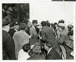
The black and white view of Howard Hughes, surrounded by crowds, as he stands before a microphone after landing his Lockheed 14 aircraft for the Around the World flight at Floyd Bennett Airfield in New York. Description on photograph's accompanying sheet of paper: "Howard Hughes (with hat) as he arrived in New York after completing a round the world flight. 7/14/38 (Press Association)"
Image

Map of California, Utah, Nevada, Colorado, New Mexico and Arizona, circa 1867
Date
1865 to 1869
Description
39 x 56 cm. Relief shown by hachures. "Entered according to act of Congress in the year 1864, by A.J. Johnson in the Clerks Office of the United States for the Southern District of New York." Atlas page numbers in upper margin: 67-68. Primer meridians: Greenwich and Washington, D.C. On verso: History and statistical view of the West India islands or Columbian Archipelago and Historical and statistical view of Mexico and Central America. Shows proposed railroads, locations of Indian tribes, natural features, counties, mines, mail routes, trails and routes of exploring expeditions. Has decorative border. Southern part of Nevada was added to the state in 1867 and is part of Nevada on this map, but Lincoln County was established in 1867 and is not on this map. This map was still probably published in 1867 in spite of someone's having written "1864" in pencil in the lower right corner of the Library's copy. Original publisher: A.J. Johnson.
Image