Search Results
Golden Nugget Gambling Hall and Eldorado Club night scene, Las Vegas, Nevada, 1949 July
Level of Description
File
Archival Collection
Anita Freeman Photograph Collection on Southern Nevada
Archival Component
Photograph of Howard Hughes at Floyd Bennett Airfield, New York, July 14, 1938
Date
1938-07-14
Archival Collection
Description
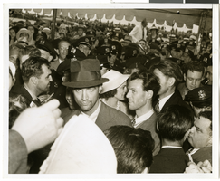
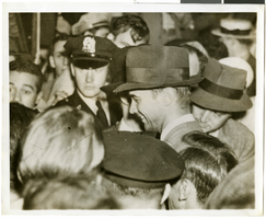
The black and white view of Howard Hughes, surrounded by crowds, after landing his Lockheed 14 aircraft for the Around the World flight at Floyd Bennett Airfield in New York. Description printed on photograph's accompanying sheet of paper: "Howard Hughes at Floyd Bennett Field after his round the world flight, 7-14-38. (Press Association)"
Image
Photograph of Howard Hughes at Floyd Bennett Airfield, New York, July 14, 1938
Date
1938-07-14
Archival Collection
Description
The black and white view of Howard Hughes, surrounded by crowds, after landing his Lockheed 14 aircraft for the Around the World flight at Floyd Bennett Airfield in New York. Description printed on photograph's accompanying sheet of paper: "Howard Hughes at Floyd Bennett Field after completing a round the world flight. 7-14-38 (Press Association)."
Image
[New Hampshire Senatorial Election]. Contains correspondence, resolutions and memos, 1975 July
Level of Description
File
Archival Collection
Howard Cannon Papers
Archival Component
Photograph of people surrounding the Lockheed 14 aircraft, New York, July 9, 1938
Date
1938-07-09
Archival Collection
Description
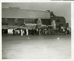
The black and white view of unidentified people surrounding the Lockheed 14 aircraft. Typed on a piece of paper attached to the image: "Rolling Howard Hughes' plane out of hangar at Floyd Bennett Field, with Lt. Thomas Thurlow, one of the navigators, calibrating the compass. 7/9/38."
Image
Colburn's New Monthly Magazine and Humorist, no. 304. London: Chapman and Hall, 1846 April 01
Level of Description
Item
Archival Collection
Mavis Eggle "Books as They Were Bought" Collection
Archival Component
Immigration, Congratulations to New Citizens. Contains correspondence, 1961 July to 1961 October
Level of Description
File
Archival Collection
Howard Cannon Papers
Archival Component

Map of California, territories of New Mexico, Arizona, Colorado, Nevada and Utah, circa 1863
Date
1861 to 1865
Description
40 x 62 cm. Relief shown by hachures and spot heights. Prime meridians: Greenwich and Washington. "Historical and statistical view of the United States, 1860"--Verso. Atlas page numbers at top: 58-59. Arizona became a territory in 1863, and Nevada became a state on October 31, 1864, so this map was either published in 1863 or in 1864 before the end of October. Original publisher: Johnson and Ward.
Image
#72831: UNLV Family Network - New Student Orientation, 2019 July 19
Level of Description
Item
Archival Collection
University of Nevada, Las Vegas Creative Services Records (2010s)
Archival Component
Howard Hughes in a crowd of people after his around-the-world flight, New York City, New York, 1938 July 13
Level of Description
File
Archival Collection
Howard Hughes Professional and Aeronautical Photographs
Archival Component