Search Results
Steel Pier marquee, Atlantic City, New Jersey: photograph, 1939
Level of Description
Item
Archival Collection
Larry Fotine Music collection
To request this item in person:
Collection Number: MS-01179
Collection Name: Larry Fotine Music collection
Box/Folder: Digital File 00
Collection Name: Larry Fotine Music collection
Box/Folder: Digital File 00
Archival Component
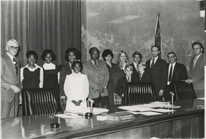
Photograph of the City of North Las Vegas Oath of Office Ceremony, January 15, 1973
Date
1973-01-15
Archival Collection
Description
Black and white photograph of the City of North Las Vegas Oath of Office Ceremony, January 15, 1973, showing Mayor C. R. Cleland (left), Councilman Theron H. Goynes (center), and Councilman James K. Seastrand (third from right).
Image
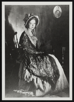
Clara Bow after winning the National Fame and Fortune Contest in New York City, New York: photographic print
Date
1921
Description
From the Nan Doughty Photograph Collection (PH-00240). Clara at age 16.
Image
#69724: College of Education Tier 1 task force symposium and reception in Greenspun Hall on May 15, 2014, 2014 May 15
Level of Description
File
Archival Collection
University of Nevada, Las Vegas Creative Services Records (2010s)
To request this item in person:
Collection Number: PH-00388-05
Collection Name: University of Nevada, Las Vegas Creative Services Records (2010s)
Box/Folder: Digital File 00
Collection Name: University of Nevada, Las Vegas Creative Services Records (2010s)
Box/Folder: Digital File 00
Archival Component
Mayor Fiorello La Guardia on the steps of City Hall receiving Howard Hughes and his crew: Ed Lund, Richard Stoddart, Thomas Thurlow, and Harry Connor, 1938 July 15
Level of Description
File
Archival Collection
Howard Hughes Public Relations Photograph Collection
To request this item in person:
Collection Number: PH-00373
Collection Name: Howard Hughes Public Relations Photograph Collection
Box/Folder: Folder 12
Collection Name: Howard Hughes Public Relations Photograph Collection
Box/Folder: Folder 12
Archival Component