Search Results
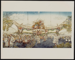
Conceptual drawings of the interior of Showboat Casino, Atlantic City, New Jersey
Date
1986
Archival Collection
Description
From the Showboat Atlantic City Photograph Collection (PH-00329).
Image
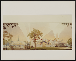
Conceptual drawings of the exterior of Showboat Casino, Atlantic City, New Jersey
Date
1986
Archival Collection
Description
From the Showboat Atlantic City Photograph Collection (PH-00329).
Image

Map of California, Utah, Nevada, Colorado, New Mexico and Arizona, 1864
Date
1864
Description
'Johnson's California, with Utah, Nevada, Colorado, New Mexico, and Arizona, published by Johnson and Ward.' 'Entered according to Act of Congress in the Year 1864 by A.J. Johnson in the Clerks Office of the District Court of the United States for the southern district of New York.' Atlas page numbers in upper margin: 66-67. This is probably plate 67 from Johnson's New Illustrated Family Atlas, published in New York by Johnson & Ward in 1864. Shows natural features, locations of Indian tribes, proposed railroad routes, routes of explorers, trails, county boundaries and populated places ; "." ; Relief shown by hachures ; Prime meridians: Greenwich and Washington ; In top margin: 66-67 ; Hand colored ; On verso: Historical and statistical view of Mexico and central America (p. 79) and Historical and statistical view of the United States, 1860 (p. 78) Scale [ca. 1:3,484,800]. 1 in. to ca. 55 miles (W 124°--W 102°/N 42°--N 32°)
Text
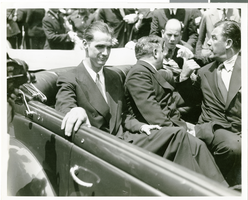
Photograph of Howard Hughes at his parade for Round the World flight, New York City, July 15, 1938
Date
1938-07-15
Archival Collection
Description
The black and white view of Howard Hughes, Mayor La Guerdia, and Grover Whalen leaving City Hall through a parade dedicated to the completion of Hughes' Round the World flight in New York City, New York.
Image
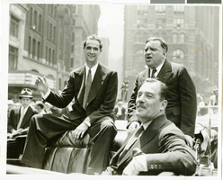
Photograph of Howard Hughes at his parade for Round the World flight, New York City, July 15, 1938
Date
1938-07-15
Archival Collection
Description
Typed onto a piece of paper attached to the image: "Leaving City Hall - 7/15/38. (Daily News)."
Image

Map of the territories of New Mexico, Arizona, Colorado, Nevada, and Utah, 1855
Date
1855
Description
29 x 36 cm. Relief shown by hachures. Prime meridians: Greenwich and Washington. "Entered according to act of Congress in the year 1855 by J.H. Colton & Co. in the Clerk's Office of the Dist. Office of the U.S. for the Southern. Dist. of New York." Hand colored. Decorative border. Atlas p. number in lower-right margin: 67. Shows routes of explorers, proposed railroad routes, wagon route, mail route, Indian reserves and mines. On verso: History and statistical view of Mexico. Original publisher: J.H. Colton.
Image

Unidentified individuals at a City Hall hearing in Las Vegas, Nevada: photographic slide
Date
1979-05
Archival Collection
Description
From the Sister Klaryta Antoszewska Photograph Collection (PH-00352).
Image

Unidentified individuals at a City Hall hearing in Las Vegas, Nevada: photographic slide
Date
1979-05
Archival Collection
Description
From the Sister Klaryta Antoszewska Photograph Collection (PH-00352).
Image

Unidentified individuals at a City Hall hearing in Las Vegas, Nevada: photographic slide
Date
1979-05
Archival Collection
Description
From the Sister Klaryta Antoszewska Photograph Collection (PH-00352).
Image

Unidentified individuals at a City Hall hearing in Las Vegas, Nevada: photographic slide
Date
1979-05
Archival Collection
Description
From the Sister Klaryta Antoszewska Photograph Collection (PH-00352).
Image