Search Results
Music Hall New Years Eve Gala Dinner 1969-1970, menu, 1969
Level of Description
File
Archival Collection
UNLV University Libraries Menu Collection
To request this item in person:
Collection Number: MS-00436
Collection Name: UNLV University Libraries Menu Collection
Box/Folder: Box 13
Collection Name: UNLV University Libraries Menu Collection
Box/Folder: Box 13
Archival Component

Photograph of Howard Hughes and crew posing for photographs outside of City Hall, New York City, July 15, 1938
Date
1938-07-15
Archival Collection
Description
Typed onto a piece of paper attached to the image: "City Hall steps - 7/15/38. (Daily News)."
Image

Map of California, with territories of Utah, Nevada, Colorado, New Mexico, and Arizona, 1864
Date
1864
Description
40 x 62 cm. Relief shown by hachures. Prime meridians: Greenwich and Washington. Page numbers at top: 58-59. "Entered according to act of Congress in the year 1864 by A. J. Johnson in the Clerk's Office of the District Court of the United States for the Southern District of New York." Original publisher: Johnson and Ward.
Image
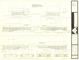
Architectural drawing of concert hall and drama theater, University of Nevada, Las Vegas, exterior elevations, November 5, 1969
Date
1969-11-05
Archival Collection
Description
Exterior elevations for the concert hall and drama theater on the University of Nevada, Las Vegas campus, including a connecting courtyard. These buildings would become the Artemus W. Ham Concert Hall and the Judy Bayley Theatre. Sheet 6 of 35. "Drawn by G.T. Checked by K.D. Job number 6828. Scale 1/16" = 1'-0". Date Nov. 5, 1969"
Site Name: University of Nevada, Las Vegas
Address: 4505 S. Maryland Parkway
Image

Map of California, Utah, Nevada, Colorado, New Mexico and Arizona, 1864
Date
1864
Description
'Johnson's California, with Utah, Nevada, Colorado, New Mexico, and Arizona, published by Johnson and Ward.' 'Entered according to Act of Congress in the Year 1864 by A.J. Johnson in the Clerks Office of the District Court of the United States for the southern district of New York.' Atlas page numbers in upper margin: 66-67. This is probably plate 67 from Johnson's New Illustrated Family Atlas, published in New York by Johnson & Ward in 1864. Shows natural features, locations of Indian tribes, proposed railroad routes, routes of explorers, trails, county boundaries and populated places ; "." ; Relief shown by hachures ; Prime meridians: Greenwich and Washington ; In top margin: 66-67 ; Hand colored ; On verso: Historical and statistical view of Mexico and central America (p. 79) and Historical and statistical view of the United States, 1860 (p. 78) Scale [ca. 1:3,484,800]. 1 in. to ca. 55 miles (W 124°--W 102°/N 42°--N 32°)
Text
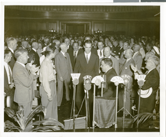
Photograph of Howard Hughes in City Hall, New York City, July 15, 1938
Date
1938-07-15
Archival Collection
Description
Typed onto a piece of paper attached to the image: "Mayor Fiorello Laguardia welcoming Howard Hughes and his four-man crew after flight Around the World. 7/15/38."
Image

Map of the territories of New Mexico, Arizona, Colorado, Nevada, and Utah, 1855
Date
1855
Description
29 x 36 cm. Relief shown by hachures. Prime meridians: Greenwich and Washington. "Entered according to act of Congress in the year 1855 by J.H. Colton & Co. in the Clerk's Office of the Dist. Office of the U.S. for the Southern. Dist. of New York." Hand colored. Decorative border. Atlas p. number in lower-right margin: 67. Shows routes of explorers, proposed railroad routes, wagon route, mail route, Indian reserves and mines. On verso: History and statistical view of Mexico. Original publisher: J.H. Colton.
Image
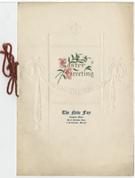
The New Fay Easter dinner menu, Sunday, April 7, 1912
Date
1912-04-07
Archival Collection
Description
Restaurant: The New Fay (Virginia, Minn.) Location: Virginia, Minnesota, United States
Text

Map of California, Utah, Nevada, Colorado, New Mexico and Arizona, 1864
Date
1864
Description
'Johnson's California, also Utah, Nevada, Colorado, New Mexico, and Arizona, published by A.J. Johnson, New York.' 'Entered according to Act of Congress in the Year 1864, by A.J. Johnson in the Clerks Office of the District Court of the United States for the Southern District of New York.' Atlas page numbers in upper margin: 66-67. Relief shown by hachures. Prime meridians: Greenwich and Washington, D.C. Shows proposed railroads, locations of Indian tribes, natural features, counties, mines, mail routes, trails and routes of exploring expeditions. On verso: History and statistics of Mexico and Central America and statistics of national finances and the Post Office of the United States, 1860. Scale [ca. 1:3,484,800. 1 in. to ca. 55 miles] (W 123°--W 103°/N 42°--N 32°)
Text
Howard Hughes standing on the outside steps of City Hall as he poses for pictures in New York City, New York, 1938 July 15
Level of Description
File
Archival Collection
Howard Hughes Public Relations Photograph Collection
To request this item in person:
Collection Number: PH-00373
Collection Name: Howard Hughes Public Relations Photograph Collection
Box/Folder: Folder 12
Collection Name: Howard Hughes Public Relations Photograph Collection
Box/Folder: Folder 12
Archival Component