Search Results
Turner, Wallace. Nevada gambling faces new test, New York Times, 1964 April 12
Level of Description
File
Archival Collection
UNLV Libraries Collection of Articles on Gaming and Las Vegas, Nevada Topics
To request this item in person:
Collection Number: MS-00626
Collection Name: UNLV Libraries Collection of Articles on Gaming and Las Vegas, Nevada Topics
Box/Folder: Box 16
Collection Name: UNLV Libraries Collection of Articles on Gaming and Las Vegas, Nevada Topics
Box/Folder: Box 16
Archival Component
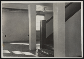
Photograph of basement stairway, Boulder City (Nev.), January 10, 1938
Date
1938-01-10
Archival Collection
Description
Foot of stairway in basement room of Boulder City Museum. Camera is facing east (approximation).
Image
T-Shirt Color: Navy Blue; Front: In Memory Of FDNY New York's Finest 9-11; Back: Impressionistic Art Piece Of New York City With Two Towers Burning And American Flag For The Sky; Handwritten Text: F-22 Donna Rimmer Knoxville, Tn., approximately 2001-2012
Level of Description
File
Archival Collection
New York-New York Hotel and Casino 9-11 Heroes Tribute Collection
To request this item in person:
Collection Number: MS-00459
Collection Name: New York-New York Hotel and Casino 9-11 Heroes Tribute Collection
Box/Folder: Box 30
Collection Name: New York-New York Hotel and Casino 9-11 Heroes Tribute Collection
Box/Folder: Box 30
Archival Component
T-Shirt Color: Navy Blue; Front: New York City; Back: Never Forget FDNY 343 WTC 9-11-2001, approximately 2001-2012
Level of Description
File
Archival Collection
New York-New York Hotel and Casino 9-11 Heroes Tribute Collection
To request this item in person:
Collection Number: MS-00459
Collection Name: New York-New York Hotel and Casino 9-11 Heroes Tribute Collection
Box/Folder: Box 85
Collection Name: New York-New York Hotel and Casino 9-11 Heroes Tribute Collection
Box/Folder: Box 85
Archival Component
New York University Graduate School of Business Administration, "A Study of the Economic Impact of the Change in the Pari-mutuel Tax on the Pari-mutuel Industry of New York State", 1980
Level of Description
File
Archival Collection
Eugene Martin Christiansen Papers
To request this item in person:
Collection Number: MS-00561
Collection Name: Eugene Martin Christiansen Papers
Box/Folder: Box 085
Collection Name: Eugene Martin Christiansen Papers
Box/Folder: Box 085
Archival Component
Howard Hughes in New York beside the Northrop Gamma Racer at the Floyd Bennett Airport after breaking the record from Miami to New York speed record, 1936
Level of Description
File
Archival Collection
Howard Hughes Public Relations Photograph Collection
To request this item in person:
Collection Number: PH-00373
Collection Name: Howard Hughes Public Relations Photograph Collection
Box/Folder: Folder 01
Collection Name: Howard Hughes Public Relations Photograph Collection
Box/Folder: Folder 01
Archival Component
Ford W. Harris and Metro-Goldwyn-Mayer Pictures New York, New York regarding similarities in parrot logo trademark, 1931 November 05 to 1931 December 03
Level of Description
File
Archival Collection
Howard Hughes Film Production Records
To request this item in person:
Collection Number: MS-01036
Collection Name: Howard Hughes Film Production Records
Box/Folder: Box 488 (Restrictions apply)
Collection Name: Howard Hughes Film Production Records
Box/Folder: Box 488 (Restrictions apply)
Archival Component
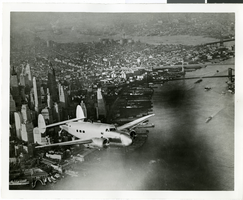
Photograph of the Lockheed 14 aircraft, July 1938
Date
1938-07
Archival Collection
Description
The black and white, skyline view of New York City with Lockheed 14 aircraft flying in the foreground. Typed onto script included with the image: "Howard Hughes plane Lockheed 14 in flight over lower New York City. To right in the background can be seen New York City's three bridges of the lower East River from front to rear: the Brooklyn Bridge, Manhattan Bridge, and the Williamsburg Bridge."
Image

Map of California, Utah, Nevada, Colorado, New Mexico and Arizona, 1864
Date
1864
Description
'Johnson's California, with Utah, Nevada, Colorado, New Mexico, and Arizona, published by Johnson and Ward.' 'Entered according to Act of Congress in the Year 1864 by A.J. Johnson in the Clerks Office of the District Court of the United States for the southern district of New York.' Atlas page numbers in upper margin: 66-67. This is probably plate 67 from Johnson's New Illustrated Family Atlas, published in New York by Johnson & Ward in 1864. Shows natural features, locations of Indian tribes, proposed railroad routes, routes of explorers, trails, county boundaries and populated places ; "." ; Relief shown by hachures ; Prime meridians: Greenwich and Washington ; In top margin: 66-67 ; Hand colored ; On verso: Historical and statistical view of Mexico and central America (p. 79) and Historical and statistical view of the United States, 1860 (p. 78) Scale [ca. 1:3,484,800]. 1 in. to ca. 55 miles (W 124°--W 102°/N 42°--N 32°)
Text
New York: Padavan, Frank, "The Dice are Rolling: Gambling with New York State's Future" report; Lynch, Gerald W., "Final Report of the Casino Gambling Study Panel New York State" report; Economic Research Service of the New York State Legislative Institute, "Casino Gambling Study" report; and Task Force on Legalized Gambling, "Easy Money" report, approximately 1974-1997
Level of Description
File
Archival Collection
Katherine A. Spilde Papers on Native American Gaming
To request this item in person:
Collection Number: MS-00092
Collection Name: Katherine A. Spilde Papers on Native American Gaming
Box/Folder: Box 15
Collection Name: Katherine A. Spilde Papers on Native American Gaming
Box/Folder: Box 15
Archival Component