Search Results
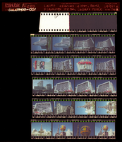
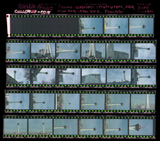
Casino exteriors: Hilton, Paris, Flamingo Hilton, Caesars Palace, Stratosphere, MGM Grand, New York-New York, Frontier Hotel, Culinary Union, Las Vegas (Nev.), 1990s (folder 1 of 1), image 1
Date
1990 to 1999
Description
Arrangement note: Series III. Internal: Work
Image
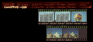
Casino exteriors: Hilton, Paris, Flamingo Hilton, Caesars Palace, Stratosphere, MGM Grand, New York-New York, Frontier Hotel, Culinary Union, Las Vegas (Nev.), 1990s (folder 1 of 1), image 2
Date
1990 to 1999
Description
Arrangement note: Series III. Internal: Work
Image
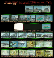
Casino exteriors: Hilton, Paris, Flamingo Hilton, Caesars Palace, Stratosphere, MGM Grand, New York-New York, Frontier Hotel, Culinary Union, Las Vegas (Nev.), 1990s (folder 1 of 1), image 3
Date
1990 to 1999
Description
Arrangement note: Series III. Internal: Work
Image
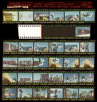
Casino exteriors: Hilton, Paris, Flamingo Hilton, Caesars Palace, Stratosphere, MGM Grand, New York-New York, Frontier Hotel, Culinary Union, Las Vegas (Nev.), 1990s (folder 1 of 1), image 4
Date
1990 to 1999
Description
Arrangement note: Series III. Internal: Work
Image
Casino exteriors: Hilton, Paris, Flamingo Hilton, Caesars Palace, Stratosphere, MGM Grand, New York-New York, Frontier Hotel, Culinary Union, Las Vegas (Nev.), 1990s (folder 1 of 1), image 5
Date
1990 to 1999
Description
Arrangement note: Series III. Internal: Work
Image

Map of California, Utah, Nevada, Colorado, New Mexico and Arizona, circa 1867
Date
1865 to 1869
Description
39 x 56 cm. Relief shown by hachures. "Entered according to act of Congress in the year 1864, by A.J. Johnson in the Clerks Office of the United States for the Southern District of New York." Atlas page numbers in upper margin: 67-68. Primer meridians: Greenwich and Washington, D.C. On verso: History and statistical view of the West India islands or Columbian Archipelago and Historical and statistical view of Mexico and Central America. Shows proposed railroads, locations of Indian tribes, natural features, counties, mines, mail routes, trails and routes of exploring expeditions. Has decorative border. Southern part of Nevada was added to the state in 1867 and is part of Nevada on this map, but Lincoln County was established in 1867 and is not on this map. This map was still probably published in 1867 in spite of someone's having written "1864" in pencil in the lower right corner of the Library's copy. Original publisher: A.J. Johnson.
Image
T-Shirt Color: White; Front: Fire Department City Of New York You Will Not Be Forgotten September 11, 2001, City Of New York Fire Emblem; Back: IAFF Rockford Firefighters Salute America's Heroes, WTC Flag Raising; Handwritten Text: God Bless The Fallen Heroes Of 9/11& Their Families From The Firefighters Of Rockford Il IAFF Local #413 Engine # 7, approximately 2001-2012
Level of Description
File
Archival Collection
New York-New York Hotel and Casino 9-11 Heroes Tribute Collection
To request this item in person:
Collection Number: MS-00459
Collection Name: New York-New York Hotel and Casino 9-11 Heroes Tribute Collection
Box/Folder: Box 411
Collection Name: New York-New York Hotel and Casino 9-11 Heroes Tribute Collection
Box/Folder: Box 411
Archival Component
Wilford, John Noble. Lure of the White Water, New York Times, 1979 July 22
Level of Description
File
Archival Collection
UNLV Libraries Collection of Articles on Gaming and Las Vegas, Nevada Topics
To request this item in person:
Collection Number: MS-00626
Collection Name: UNLV Libraries Collection of Articles on Gaming and Las Vegas, Nevada Topics
Box/Folder: Box 15
Collection Name: UNLV Libraries Collection of Articles on Gaming and Las Vegas, Nevada Topics
Box/Folder: Box 15
Archival Component
Sweepstakes and Jai Alia tickets; sweepstakes tickets from Cambridgeshire, England, New York, New York; and Dublin, Ireland; Jai Alia tickets and program from Fronton, Mexico, approximately 1964 to 1975
Level of Description
File
Archival Collection
UNLV Libraries Collection of Gaming Artifacts and Ephemera
To request this item in person:
Collection Number: MS-00110
Collection Name: UNLV Libraries Collection of Gaming Artifacts and Ephemera
Box/Folder: Box 13
Collection Name: UNLV Libraries Collection of Gaming Artifacts and Ephemera
Box/Folder: Box 13
Archival Component
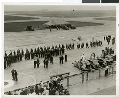
Photograph Howard Hughes arrival at Floyd Bennett Airport, New York, July 14, 2013
Date
1938-07-14
Archival Collection
Description
The black and white view of a crowd of people awaiting the arrival of Howard Hughes at Floyd Bennett Airport in New York. Typed onto a piece of paper attached to the image: "Just before world fliers landed, Floyd Bennett Airport, N.Y. -- A small army of policemen pictured on the runway here shortly before Howard Hughes and his four companions landed, ending their Round-The-World flight. Note newsreel photographers on the right. In the background is the tent from which Hughes and his fellow fliers spoke to a vast radio audience. Credit line (ACME) 7(3/4)/14/38."
Image