Search Results

Map of California, and territories of Utah, Nevada, Colorado, New Mexico and Arizona, 1864
Date
1864
Description
'Johnson's California, also Utah, Nevada, Colorado, New Mexico, and Arizona, published by A.J. Johnson, New York.' 'Entered according to act of Congress in the year 1864, by A.J. Johnson in the Clerks Office of the District Court of the United States for the southern district of New York.' Atlas page numbers in upper margin: 67-68. Relief shown by hachures. Prime meridian: Greenwich and Washington. Shows natural features, locations of Indian tribes, proposed railroad routes, routes of explorers, trails, county boundaries and populated places. Hand colored. On verso: 'Historical and statistical view of the West India Islands or Columbian Archipelago' (p. 80) and 'Historical and statistical view of Mexico and Central America' (p. 79). Scale [ca. 1:3,484,800]. 1 in. to ca. 55 miles (W 124°--W 102°/N 42°--N 32°).
Text
A Matter of Minutes: Gunfire, Chaos and Death - The New York Times: archived website, 2017
Level of Description
Other Level
Archival Collection
Web Archive on the October 1, 2017 Shooting in Las Vegas, Nevada
To request this item in person:
Collection Number: MS-00866
Collection Name: Web Archive on the October 1, 2017 Shooting in Las Vegas, Nevada
Box/Folder: N/A
Collection Name: Web Archive on the October 1, 2017 Shooting in Las Vegas, Nevada
Box/Folder: N/A
Archival Component
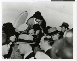
Photograph of Howard Hughes exiting the Lockheed-14 at the Floyd Bennett Airport, New York, July 14, 1938
Date
1938-07-14
Archival Collection
Description
Howard Hughes getting out of cabin door of Lockheed-14 at the Floyd Bennett Airport in New York in 1938.
Image
T-Shirt Color: Navy Blue; Front: In Memory Of Our Fallen Brother PO Stephen Driscoll, City Of New York Police 17482, Police Officer Badge; Back: The Other Twin Towers Of New York, Fire Fighter And Police Officer Standing In Place Of Twin Towers, NYC Burning, approximately 2001-2012
Level of Description
File
Archival Collection
New York-New York Hotel and Casino 9-11 Heroes Tribute Collection
To request this item in person:
Collection Number: MS-00459
Collection Name: New York-New York Hotel and Casino 9-11 Heroes Tribute Collection
Box/Folder: Box 331
Collection Name: New York-New York Hotel and Casino 9-11 Heroes Tribute Collection
Box/Folder: Box 331
Archival Component
T-Shirt Color: Gray; Front: Fire Department City Of New York 09/11/01 We Will Not Forget, Fire Dept. Emblem And Dalmatian Dog, approximately 2001-2012
Level of Description
File
Archival Collection
New York-New York Hotel and Casino 9-11 Heroes Tribute Collection
To request this item in person:
Collection Number: MS-00459
Collection Name: New York-New York Hotel and Casino 9-11 Heroes Tribute Collection
Box/Folder: Box 111
Collection Name: New York-New York Hotel and Casino 9-11 Heroes Tribute Collection
Box/Folder: Box 111
Archival Component
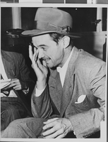
Photograph of Howard Hughes after hearing, Culver City, California, August 15, 1947
Date
1947-08-15
Archival Collection
Description
Description given with photo: "Tired Hughes Returns Home, Culver City, Cal. : Rubbing his tired eyes, Howard Hughes talks with reporters at an informal press conference at his plant in Culver City after his return flight from Washington. He said the hearings in which he participated were fair, and said the press and public made it "Impossible for Brewster to continue his Gestapo methods". Credit (ACME) 8/15/47."
Image
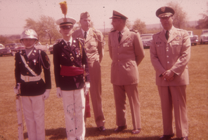
Photo of Mr. Ormsby, officers and cadets in Fort Niagara, New York: photographic slide
Date
1961-06
Archival Collection
Description
From the Sister Klaryta Antoszewska Photograph Collection (PH-00352)
Image
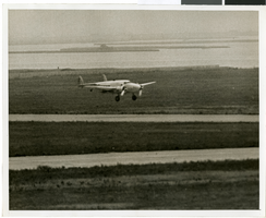
Photograph of the landing of Howard Hughes' Lockheed 14 aircraft, New York, July 14, 1938
Date
1938-07-14
Archival Collection
Description
The black and white, aerial view of Howard Hughes' Lockheed 14 aircraft performing its final landing on the Round the World flight in Floyd Bennett Airport, New York. Typed onto a piece of paper attached to the image: "Flight's End: Floyd Bennett Airport - Howard Hughes' silver monoplane, "World's Fair, 1939," as the skimmed the runway just before landing at 2:37 1/2 p.m., to end a dramatic dash around the world. A minutes later, Hughes and his companions were mobbed by officials. Credit (ACME). 7/14/38."
Image
Rainbow Plaza Resort Hotel Development: Niagara Falls, New York, 1979 September 1
Level of Description
Series
Archival Collection
Martin Stern Architectural Records
To request this item in person:
Collection Number: MS-00382
Collection Name: Martin Stern Architectural Records
Box/Folder: N/A
Collection Name: Martin Stern Architectural Records
Box/Folder: N/A
Archival Component
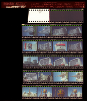
Casino exteriors: Hilton, Paris, Flamingo Hilton, Caesars Palace, Stratosphere, MGM Grand, New York-New York, Frontier Hotel, Culinary Union, Las Vegas (Nev.), 1990s (folder 1 of 1), image 1
Date
1990 to 1999
Description
Arrangement note: Series III. Internal: Work
Image