Search Results
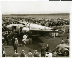
Photograph of the Lockheed 14 aircraft, Fairbanks, Alaska, July 15, 1938
Date
1938-07-15
Archival Collection
Description
The black and white view of Howard Hughes' Lockheed 14 aircraft being refueled in Fairbanks, Alaska. Typed on a piece of paper attached to the image: "C.850170 Howard Hughes' plane being re-fueled at Fairbanks, Alaska on the last lap of its round the world flight. 7/15/38."
Image
Resorts International Hotel: Atlantic City, New Jersey, 1982-07-22
Level of Description
Series
Archival Collection
Martin Stern Architectural Records
To request this item in person:
Collection Number: MS-00382
Collection Name: Martin Stern Architectural Records
Box/Folder: N/A
Collection Name: Martin Stern Architectural Records
Box/Folder: N/A
Archival Component
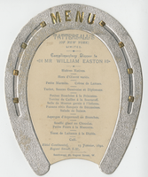
Tattersall's complementary dinner to William Easton, menu, January 15, 1892, Hotel Continental
Date
1892-01-15
Archival Collection
Description
Note: Horse shoe shaped menu Restaurant: Hotel Continental (London, England) Location: Regent Street, S. W., London, England
Text


Photograph of people surrounding the Lockheed 14 aircraft, New York, July 9, 1938
Date
1938-07-09
Archival Collection
Description
The black and white view of unidentified people surrounding the Lockheed 14 aircraft. Typed on a piece of paper attached to the image: "Rolling Howard Hughes' plane out of hangar at Floyd Bennett Field, with Lt. Thomas Thurlow, one of the navigators, calibrating the compass. 7/9/38."
Image

Map of the city of Las Vegas, Nevada, June 1, 1946
Date
1946-06-01
Description
Scale [ca. 1:9,600. 1 in. to approx. 800 ft.]. Cadastral map. 'Compiled by Pioneer Title Insurance &Trust Company.' 'By Jack Asher, State Nev. Reg. Engr. No. 305.' 'Issue 5, 6/1/46.' Includes indexes. Pioneer Title Insurance &
Trust Company
Trust Company
Image
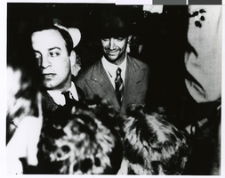
Photograph of Howard Hughes after arriving from his flight around the world, New York, July 13, 1938
Date
1938-07-13
Archival Collection
Description
Howard Hughes (center) in a New York City crowd of people after his around the world flight.
Image
Immigration, Congratulations to New Citizens. Contains correspondence, 1961 July to 1961 October
Level of Description
File
Archival Collection
Howard Cannon Papers
To request this item in person:
Collection Number: MS-00002
Collection Name: Howard Cannon Papers
Box/Folder: Box 11 (87th Session)
Collection Name: Howard Cannon Papers
Box/Folder: Box 11 (87th Session)
Archival Component

Map of California, territories of New Mexico, Arizona, Colorado, Nevada and Utah, circa 1863
Date
1861 to 1865
Description
40 x 62 cm. Relief shown by hachures and spot heights. Prime meridians: Greenwich and Washington. "Historical and statistical view of the United States, 1860"--Verso. Atlas page numbers at top: 58-59. Arizona became a territory in 1863, and Nevada became a state on October 31, 1864, so this map was either published in 1863 or in 1864 before the end of October. Original publisher: Johnson and Ward.
Image