Search Results
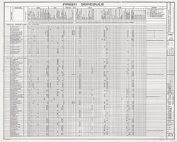
Showboat Hotel and Casino (Atlantic City), finish schedule, second floor and third floor, July 22, 1985
Date
1985-07-22
Archival Collection
Description
Plans for the construction of the Showboat Hotel Casino in Atlantic City from 1985. John A. Martin, structural engineer; Albert A. Hellman, mechanical engineer; Norman A. Cohen, electrical engineer.
Site Name: Showboat Hotel and Casino (Atlantic City)
Address: 801 Boardwalk, Atlantic City, NJ
Text

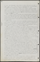

Letter from J. Ross Clark (Los Angeles) to W. H. Bancroft (Salt Lake City), July 21, 1909
Date
1909-07-21
Archival Collection
Description
Clark recommends replacing the sheet metal pipeline with concrete to fix a massive leaking problem.
Text
Ryann Juden (City of North Las Vegas, City Manager) oral history interview conducted by Kelliann Beavers, 2022 July 14
Level of Description
Item
Archival Collection
Lincy Institute "Perspectives from the COVID-19 Pandemic" Oral History Project
To request this item in person:
Collection Number: MS-01178
Collection Name: Lincy Institute "Perspectives from the COVID-19 Pandemic" Oral History Project
Box/Folder: Digital File 00
Collection Name: Lincy Institute "Perspectives from the COVID-19 Pandemic" Oral History Project
Box/Folder: Digital File 00
Archival Component
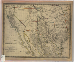
Map of Utah, New Mexico, Texas, California, Indian territory, and the northern states of Mexico, 1852
Date
1852-01-01
Description
At head of title: 'North America, sheet XV.' 'Published under the superintendence of the Society for Diffusion of Useful Knowledge.' At bottom center of map:'London, Charles Knight, Jany. 1st, 1852.' At bottom right of map: ' J. & C. Walker Sculpt.' Scale [1:7,500,000] 1 degree to 68.89 English miles (W 125°--W 92°/N 43°30?--N 22°30?). Relief shown by hachures. Atlas page number in lower margin: 144. Boundaries hand colored. Includes notes, locations of Indian tribes, population statistics. Charles Knight.
Image

Geologic map of the northeast quarter of the Bullfrog 15-minute quadrangle, Nye County, Nevada, 1990
Date
1990
Description
58 x 46 cm., on sheet 87 x 102 cm., folded in envelope 30 x 24 cm. Relief shown by contours and spot heights. "Contour interval 40 feet." "Base from U.S. Geological Survey 1:62,500. 1954." "Geology mapped in 1985 and 1988." Includes text, bibliography, 4 col. cross sections, and location and index maps. "Prepared in cooperation with the U. S. Atomic Commission." Original publisher: U. S. Geological Survey, Series: Miscellaneous investigations series, map I, Scale: 1:24 000.
Image