Search Results
Photograph of the Lockheed 14 aircraft, July 1938
Date
1938-07
Archival Collection
Description
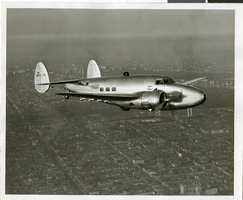
The black and white, skyline view of New York City with Lockheed 14 flying in the foreground. Typed onto script included with the image: "Howard Hughes plane in flight over New York City. July 1938."
Image

Photograph of the Lockheed 14 aircraft, July 1938
Date
1938-07
Archival Collection
Description
The black and white, skyline view of New York City with Lockheed 14 flying in the foreground. Typed onto script included with the image: "Howard Hughes plane in flight over New York City. July 1938."
Image
Showboat Hotel Casino: Atlantic City, New Jersey, 1984 October 23; 1987 January 23
Level of Description
Series
Archival Collection
Martin Stern Architectural Records
To request this item in person:
Collection Number: MS-00382
Collection Name: Martin Stern Architectural Records
Box/Folder: N/A
Collection Name: Martin Stern Architectural Records
Box/Folder: N/A
Archival Component

Photograph of charter officers for the new North Las Vegas Exchange Club, North Las Vegas, Nevada, July 31, 1972
Date
1972-07-31
Archival Collection
Description
Charter officers of new North Las Vegas Exchange Club, North Las Vegas, Nevada, July 31, 1972. Pictured L-R: Noel Thompson, President; Richard Cross, Vice-President; Bill Cyphers, Board Member; Warren Wilson, Secretary; Roland Bobier, Board Member; Gary Gray, Board Member.
Image