Search the Special Collections and Archives Portal
Search Results
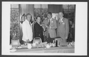
Photograph of Wendell Tobler receiving gavel as new president of the North Las Vegas Chamber of Commerce, North Las Vegas, Nevada, July, 1973
Date
1973-07
Archival Collection
Description
Wendell Tobler receives gavel as new President of North Las Vegas Chamber of Commerce from Joe Cunningham, outgoing President, July, 1973. Pictured L-R: Robert Goodman, Wendell Tobler, Joe Cunningham, Charles Enson.
Image
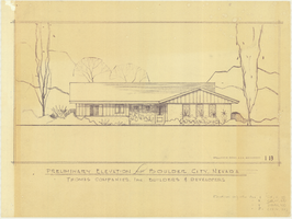
Architectural drawing of residential home in Boulder City, Nevada, preliminary elevation, 1962
Date
1962
Archival Collection
Description
Preliminary drawing of front exterior elevation of ra anch-style residential home in Boulder City, Nevada. Handwritten near lower right: "Elevations only for Plan 1 (1B, 1C, 1D), Plan 2 (2B, 2C, 2D), Plan 4 (4B, 4C, 4D), Plan 5 (5B, 5C, 5D)."
Architecture Period: Mid-Century ModernistImage

Pagination
Refine my results
Content Type
Creator or Contributor
Subject
Archival Collection
Digital Project
Resource Type
Year
Material Type
Place
Language
Records Classification


